Volume 22, Issue 5, May 2026 |
|
|||||||||||||||||||||||||||||||||||||
|
|||||||||||||||||||||||||||||||||||||
Volume 22, Issue 4, April 2026 |
|
|||||||||||||||||||||

This paper reviews how technology could play a crucial role in a global pandemic for timely dissemination of information and operational decision-making
Rishiraj Dutta
Asian Disaster Preparedness Center Bangkok, Thailand
With the COVID-19 pandemic spreading rapidly across the world, one of the important aspects that came to the forefront is the role of information and communications technology. While …
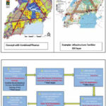
The geospatial information in digital format generated under the projects were inputs to other land administration processes which significantly improved the delivery of services, access and transparency while contributing to a more reliable, efficient and effective land administration and management system
Richard Oput
Land Administration/ Geomatics Consultant, Uganda
Abstract
Uganda got a new Constitution in 1995 which had fundamental …

This paper highlights humorous research related to typical problems encountered in the workplace office environment, which are investigated using spatial tools, physics and artificial intelligence
Volker Janssen
Publications Officer, Association of Public Authority Surveyors (APAS), New South Wales, Australia
This is the second in a series of papers celebrating some of the weird and wonderful research findings hidden …

The paper analyzes the implementation process, provides an overview of the preexisting problems and discusses the means on how the Pilot Project has addressed the shortcomings
Elene Grigolia
Blockchain Consultant LMD Component Manager World Bank Funded Project “ILMD” National Agency of Public Registry, Georgia
Teimuraz Gabriadze
Senior Legal Consultant Irrigation and Land Market Development Project National Agency of Public …
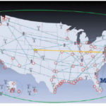
Timing is essential to our economic and national security. It is needed to synchronize networks, for digital broadcast, to efficiently use spectrum, for properly ordering a wide variety of transactions…


 |
Introduction To Geodesy... |
 |
This comprehensive book charts the course of NSDI journey in India, which is still continuing... |
 |
“The problem of GNSS disruptions will never be solved, but it can be much better managed”
Dana A. Goward |


 (5.00 out of 5) (5.00 out of 5) (5.00 out of 5) (5.00 out of 5)
