| Applications | |
Modernization of land administration services in Uganda
The geospatial information in digital format generated under the projects were inputs to other land administration processes which significantly improved the delivery of services, access and transparency while contributing to a more reliable, efficient and effective land administration and management system |
|
Abstract
Uganda got a new Constitution in 1995 which had fundamental provisions for Land Administration and Management which were aimed at creating a favorable working policy, legal and regulatory environment. A long term Land Sector Strategic Plan was developed to guide implementation of the various Land Sector reforms. The Strategy had major provisions for modernization of Land Administration services which were driven by reforms promoted by Projects which aimed at modernizing delivery of land services through implementation of various activities with major components which involved digitization of geospatial information and the associated processes.
The geospatial information in digital format generated under the projects were inputs to other land administration processes which significantly improved the delivery of services, access and transparency while contributing to a more reliable, efficient and effective land administration and management system.
Finally the paper discusses the achievements realized and challenges experienced in modernization of land administration services.
Background
Uganda got a new Constitution in 1995 which had fundamental provisions for land administration and management which were aimed at creating a favorable working policy, legal and regulatory environment. It was also hoped that improvement in efficiency and effectiveness of delivery of land services would naturally follow. Furthermore, there was a provision to put in place the Land Act within two years of coming into force of the new Constitution. However, after enactment of the Land Act in 1998, there were quite a number of challenges which were faced during implementation of the new Act. One of the major bottlenecks identified during implementation was the large unfordable implementation structure, the spirit of which was to take services closer to the people, which were also meant to be much cheaper and therefore more affordable for the majority of the people. A Land Act Implementation Study (LAIS) which was carried out in 1999, that is one year after enactment of the Land Act, identified the challenges which were faced during implementation of the Act and made a number of recommendations which included among other things, streamlining the implementation structure for the Land Act. After reviewing the recommendations which were made in the Land Act Implementation Study, Cabinet directed the Ministry of Lands to develop a Strategic Action Plan for implementation of Land Sector reforms including implementation of the Land Act. Following the Cabinet directive, the Ministry developed the 10 year Land Sector Strategic Plan (LSSP I), which was approved by Cabinet in 2002. The LSSP I was designed to provide the operational, institutional and financial framework for the implementation of sector wide reforms and land management including the implementation of the Land Act. The LSSP I had major provisions for modernization of land administration services which were driven by reforms introduced during implementation of the Land Tenure Reform Project (LTRP), followed by the Second Private Sector Competitiveness Project (PSCP II) and later by the Competitiveness and Enterprise Development Project (CEDP), which last two projects were funded by the World Bank. These Projects aimed at modernizing delivery of land services through implementation of various activities with major components which involved digitization of geospatial information and the associated processes, resulted in improvement of delivery of land services which were much faster and cheaper and proved to be more efficient and effective, as well. The LSSP II (2013 – 2023) has strategies aimed at scaling up the programs initiated under the LSSP I, refocuses and strengthens the efforts aimed at modernizing delivery of land services with the major objective of provision of much more efficient and effective land services buttressed by digitization of geospatial and other land related information and automation of previously manually based processes.
Introduction
Implementation of the LSSP started in earnest in mid-2005 when a World Bankfunded project was initiated, which enabled Government to start addressing the inefficient administration and poor security of the country’s land registration system, while also updating and strengthening the policy and regulatory framework for land administration and management. The Land Component of the Second Private Sector Competitiveness Project (PSCP II) supported the rehabilitation/ construction of 13 zonal land offices (including the provision of equipment); the re-engineering and computerizing of the land registration system and records in six zonal land offices covering about 70 percent of the formal land market transactions; and rehabilitating the Institute of Surveying and Land Management, and training and equipping staff to run the systems and institutions. The Project achieved significant progress in the areas of decentralizing and computerizing the land registration system. In particular, the intervention resulted in a reduction in the number of days to transfer property from 227 in 2006 to 52 in 2012. In addition, the initiative also rehabilitated the geodetic reference network and produced multi-purpose base maps for the areas covered by the six zonal land offices.
The PSCP II together with Government support under the LTRP, also supported the preparation and adoption of the overarching policy framework for land administration and management, which was essential for addressing the first three objectives of LSSP I, which dealt with equitable and secure access to land and its productive use and pilot activities. Notable achievements were the support for the National Land Policy, which was approved by the Cabinet in February 2013; the National Land Use Policy, which was adopted in 2007, followed by enactment of the Physical Planning Act 2010; the Mortgage Act 2009; and the Land (Amendment) Act 2010 to reduce illegal evictions. In addition, support was given to the preparation and drafting of nine bills, including the Registration of Titles Bill, the Survey Bill, the Surveyors Registration (Amendment) Bill, the Real Estate Agents Bill, the Condominium Property (Amendment) Bill, the Land Acquisition Bill, the Government Land Bill and the Uganda Land Information Systems Bill.
The piloting supported by the PSCP II together with Government support under the LTRP included systematic titling of high-value rural land in Ntungamo, Iganga, and Mbale districts using best practice, low-cost, and transparent approaches. The data capture was carried out using affordable GPS equipment and the associated data processing was mainly carried out in digital format.
It should be noted that additional interventions were needed to support implementation of the LSSP’s strategic objectives, which had been grossly underfunded and this was made possible under the CEDP.
The CEDP addresses those issues which were highlighted as priority areas for action in the second LSSP (2013-2022) and required a major boost, but had remained unfunded due to financing constraints. Such key areas include: registration/certification of communal lands in the North and East; registration of individual land parcels all over the country; piloting and scaling up improved land use planning models in strategic areas; and strengthening land dispute resolution.
Enhancement of delivery of land services buttressed by digitization of geospatial information
Modernization of land administration and management services supported by digitization of geospatial information and automation of some associated processes was carried out mainly under 5 Sub-Projects under the Land Component of the Competiveness and Enterprise Development Project (CEDP). These included Development of the National Physical Development Plan; Modernization of the National Geodetic Network and Establishment of Continuously Operating Reference Stations (CORS); Production of Basemaps for Land Administration; Systematic Adjudication, Demarcation and Certification/Registration of Individual and Communally Owned Land; and Development and Implementation of the National Land Information System.
Development of the National Physical Development Plan (NPDP)
Uganda’s long-awaited first National Physical Development Plan (NPDP), comes from a background of its modern Physical Planning systems, which originated in the construction of trading and administrative centers during the preindependence period, but which work was based on paper based manual operations.
A central objective of the NPDP is to give the physical aspect of planning development a more central role within Government policy-making. It will help to coordinate and align national projects in urbanization, infrastructure, transportation, and wealth creating sectors.
The National Physical Development Plan provides the analytical parameters for the planned allocation, use and management of the country’s land and other physical resources, as well as the most efficient location of infrastructure, towns and cities, and how they link to the surrounding rural areas. It is intended to serve as a framework through which the spatial location of investments, as well as planning and management of resources are guided at the national level.
The Physical Planning system, as defined in the Physical Planning Act 2010, works at different levels from the national down to the detailed local level, and covers the whole country. By being integrated with Economic Development Planning, it will assist with the dissemination of the NDPs down to Local Government levels. The NPDP therefore also contains an overall plan and program for capacitating the Physical Planning System to be effective across the whole country, as it develops.
Much more efficient Physical Planning processes have been made possible with the arrival of (digital) Geographical Information Systems (GIS). The process of updating and sharing data will be greatly facilitated by the Uganda Spatial Development Framework (UGSDF), which will ensure that core data sets are freely available and that a common frame of reference for GIS data is used.
Digital spatial data systems will play a key role in implementing the NPDP as pillars/sub pillars have GIS layers which are the same as the NSDI core layers, besides the NSDI will enable some ongoing self-coordination by its users. Using the PPUMIS, the DPPUD will be able to check if individual MDA project proposals conform to NPDP – 5,10,15,20 year strategies, guidelines and principles.
Physical Planning and Urban Management Information System (PPUMIS)
The overall aim of the Physical Planning and Urban Management Information System (PPUMIS) was to set up Geographical Information and related systems in the Ministry of Lands and in 14 Municipalities in order to store, validate and coordinate spatial data, prepare and implement Physical Development Plans and manage Urban Development faster, more effectively and efficiently.
The PPUMIS will enhance planning, preparation, implementation and monitoring of the urban processes. The system will include a database to facilitate data collection, storage, display and spatial analysis and it is based on a comprehensive Geographical Information System with the abilities to synchronize data between the Ministry and the 14 municipalities; import, enhance and display Physical Development Plans for intelligible use; provide analysis and update capabilities for urban data, in particular, Street Naming and Building Numbering Process and Monitoring of Urban Indicators. With regard to implementation of the NDP, PPUMIS is linked with the LIS and Local Governments and Plans can be transmitted and incorporated thereby in Plans at lower levels, furthermore LIS Physical Planning checks at MZOs as part of land management and administration system, will also then assist with NDP implementation.
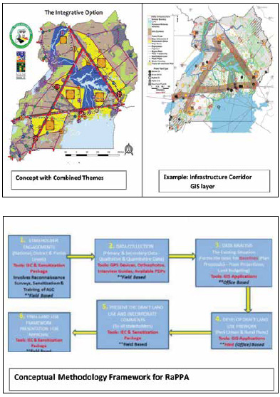
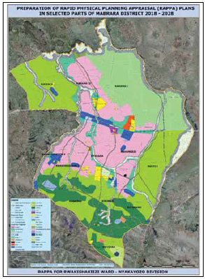
Rapid Physical Planning Appraisal (RaPPA)
RaPPA is a guide to the development direction of a given area in a systematic procedure based on the analysis and triangulation of data acquired through a consultative and qualitative manner. The Physical Planning Act 2010 declares the whole country a planning area, this implies that as part of procedures for registration of land titles, there will be a requirement for Physical Planning approvals to be given as part of the process for titling. Therefore the system of “Rapid Physical Planning Assessment” was devised in order to do the necessary planning for the SLAAC process.
The Ministry adopted RaPPA to precede the SLAAC process and developed internal capacity and is able to develop RaPPA plans for the Physical Development Frameworks for the Districts, Sub Counties and Parishes. At the Parish level, planning is done in detail to map out the public facilities, access roads, environmental sensitive areas, cultural and tourism sites for preservation. At this level, the development path for a Division/ Ward/Parish is determined and planning instructions issued to guide SLAAC.
The activities involved in RaPPA include Processing/Preparation of Base Maps, Conducting Reconnaissance Surveys, Training of Land Management Institutions (LMIs), Sensitization of Local Communities, Developing of RaPPA Framework Plan, and Presenting Draft RaPPA Framework to Stakeholders. Outputs of RaPPAs which are mainly in digital format are direct inputs to the Systematic Land Adjudication and Certification (SLAAC) Project and together with all the processes handled in a digital environment, have significantly contributed to improvement in the efficiency and effectiveness of implementation of the land administration and management processes.
It should be noted that the volume of work involved requires that highly effective database management and automated systems based on digital geospatial data, will be needed to achieve the outputs in time.
Updating and implementing of the National Geodetic Reference Framework for land administration
The objective of the Uganda Geodetic Reference Framework (UGRF) Project, initiated by the Government of Uganda with the assistance of the World Bank, was to establish a modern, reliable and accurate geodetic reference frame for the entire country to support land administration, physical planning, land development, construction industry, environment protection and other spatial data activities in different sectors of economy. The UGRF consists of a three level architecture network including a Zero Order sub network of active CORS, a First Order sub network and a Second Order sub network of passive geodetic points.
The CEDP funded modernization of land administration by establishment of a geodetic reference framework and Continuously Operating Reference Stations. This has contributed to the enhancement of land administration services, improvement of their reliability and will increase public confidence in the land administration sector.
Uganda Geodetic Reference Network (UGRN)
The UGRN is composed of two types of geodetic control networks. These are the Active Control Network (Continuously Operating Reference stations) and the Passive Control Network (Terrestrial Reference Stations); Transformation Parameters – The Surveys and Mapping Department (SMD) had been working to determine transformation parameters between the old datum “New Arc 1960” and the ITRF05. The UGRN has also generated better parameters CORS – These are also referred to as the Active Control Network, there are currently composed of 12 CORS with a plan to increase them to 28 CORS exclusive of the private sector which will be included to improve on the robustness of the network. The CORS are installed in mainly Ministry premises and other Government facilities and these transmit data to the National Computing Centre (NCC) at the National Land Information Centre (NLIC).
Passive Control Network (Terrestrial Reference Stations) – These are made up of 14 Zero Order points known as Uganda Geodetic Network (UGN), 129 1st Order points and 297 2nd Order Points, making a total of 440 Passive points.
Major changes have been brought about by the use of Internet:
• Products have changed – They are Internet based (data, real time corrections) – Online processing – Online transformation and geoid software; the paper description card is no longer a product
• Products update – It is easy to update coordinates and description cards – Improvements and maintenance can be handled easily
• Information sharing – People want up-to-date information – Users can easily give feedback (social networks but also and more interestingly feedbacks on existence of points)
It has been made possible to practice Modern Geodesy:
• CORS network website (rinex files, data QC, etc) http://ugrf.go.ug/SBC
• On line post processing http:// ugrf.go.ug/SBC/User/Xpos/
• Description cards (no need for login) http://ugrf.go.ug/carto
• Transformation parameters and interim geoid software (to be downloaded for free, no need for login): http://ugrf.go.ug/download
It is now possible for users to follow online data availability, data quality and to process their own data online using the website which has been put in place.
Real Time data is now available on NTRIP Caster for any user who simply needs to register online and RTK corrections and processed coordinates are provided in the official UGRN reference framework.
This project has made it much faster, cheaper and more efficient to carry out a typical survey exercise as a result of data capture and processing of geospatial information in digital format

Production of basemaps for land administration
The main objective of this Project is to establish high resolution and accurate Digital Ortho-rectified Imagery (DOI) for the whole country to support the National Land Information System Infrastructure, land registration and cadastral procedures, land valuation, physical planning as well as decision making for land management and protection of the environment.
The Project also aimed at contributing to the enhancement of land administration services in the country, improvement of their reliability and increasing public confidence in the land administration sector and enhancement of social economic development in the country.
The outputs include Aerial Photography, Digital Elevation Models, Digital Orthorectified Images (15 cm resolution for urban areas and 40 cm resolution for the whole country), all produced in digital format. The Digital Orthorectified Images and associated data are used directly in the UgNLIS, SLAAC, Physical Planning and as a base for revision of the Topographic Maps, at all scales and engineering works involving planning way leaves, power lines; water lines.
Because of the relative ease of handling and storage in digital format, the DOI have been shared with many institutions requiring use of this data – which has been made easier compared to previous cases when most map data was paper based.
Systematic Land Adjudication And Certification (SLAAC)
This involves demarcation and registration of individual lands in rural and periurban areas (including issuance of titles to said individuals) ensuring application of fit-for-purpose approaches that are cost effective and that will ensure fast expansion of coverage of registered land; establishing Communal Land Associations (CLAs) in priority areas; demarcation and registration of communal lands in the priority areas and issuance of certificates or titles to said CLAs.
The systematic demarcation activities initiated and piloted during LSSP I (2001-2011) were rolled out under the CEDP. These activities included:
• Systematic registration of individual and communally owned land through establishing Communal Land Associations (CLAs) in priority areas including the Northern and Eastern Regions;
• Demarcation and registration of communal lands in priority areas and issuance of titles to Communal Land Associations; and
• Demarcation and registration of individual lands in rural and peri-urban areas including issuance of titles
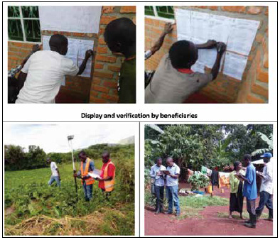
The use of the Systematic Land Adjudication and Certification (SLAAC) application supports issuance of Certificates of Customary Ownership, Communal Land Associations and Freehold Titles. It is a collection of tools, procedures and infrastructure which assist the Ministry of Lands, Housing and Urban Development in the data collection, mapping, and processing of spatial and other land related data, which is carried out in digital format.
The objective of the use of the SLAAC application is to increase the rate of land registration and certification, secure land rights for vulnerable groups, increase productivity and use of the documented rights to contribute to improvement of social economic development in the Country.
The application is based on mobile tablets installed with Windows operating system and now being upgraded to Android operating system and is based on open source software running on a Postgres/ PostGIS database, Alfresco and QGIS software for mapping. Digital Orthorectified Imagery or orthophotos are used as a base while carrying out the demarcation of boundaries and other data capture procedures. The application is also used in the data processing and the associated quality control processes in the Data Processing Centre (DPC) including monitoring and evaluation, production of reports and final outputs including maps and information required in the titling process.
Currently, the SLAAC tool is being used in Mbarara, Oyam, Ibanda and Kiruhura Districts and the titling process is ongoing.
Overall, the procedures followed supported by availability of data in digital form are much more reliable, efficient and promotes transparency compared the paper based manual processes which are cumbersome, inefficient and prone to mistakes and interference in the processes.
Development and Implementation of the National Land Information System (NLIS)
Development and implementation of the NLIS incorporates cadastral, registration, valuation and physical development planning functions in all zonal land offices (including conversion of associated land records) and moreover there will be significant improvement of monitoring of performance of various aspects involved in land transactions; Furthermore the land information system will be linked to the tax authority, courts, land use, financial institutions, national identification registration authority, company registry and administrator general to ensure reliable and authentic land transactions.
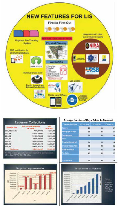
The following improvements in the new NLIS have been supported by the availability of geospatial and other land related data in digital form: The new system is based on Open Source components; Web architecture; Improved data model (LADM compliant, simplified); A unified data model used for registry and cadaster in order to assure database consistency; Handling of land transactions submitted – Queuing based on First Come, First Served; Integration with other Government systems; Customer Call Centre for the Public; Staff, Public and Corporate Web Portals; Physical File Tracking System; Administrative dashboard for Managers; SMS Notification for all land transactions; Improved operations and modules to reflect user experience in the pilot phase – Simplified transactions and workflows.
The National Land Information System has been installed and is operational in 22 Ministry Zonal Offices of Wakiso- (Busiro and Kyadondo), Mukono, Masaka, Kampala (KCCA), Masindi, Kibaale, Kabarole, Mbarara, Arua, Gulu, Lira, Mbale and Jinja. Others are Mpigi, Luwero, Mityana, Kabale, Rukungiri, Tororo, Moroto and Soroti respectively.
The objective of establishing Ministry Zonal Offices (MZOs) and development of the National Land Information System is:
a. To bring the Ministry’s services closer to people who had to bear all inconveniences and indirect costs of moving frequently to the Capital City (Kampala) to access Ministry’s services.
b. To digitally store and archive land Information for easy and timely access of information by both the service provider and the public for quick decision making.
c. To detect and eliminate any possibilities of fraudulent practices in the land transaction process such as double titling, overlapping surveys among others.
d. To improve the internal efficiency of Land Administration operations, provision of prompt, efficient, reliable and wide range of land services to clients.
e. To efficiently and effectively disseminate land information to the public.
f. To capture all the land tenure systems in the Land Information System.
g. To increase revenue generation by the Lands Sector.
h. To provide more time for land administrators and managers to offer specialized consultation, sensitization and technical guidance both to clients and Land Management Institutions.
The benefits, some of which have so far been realised from establishing Ministry Zonal Offices and implementation of the National Land Information System include:
a. Reduced cost of doing business as a result of quick retrieval of information and speedy land transactions;
b. Reduced turnaround time for producing land title from 52 days to 10 days;
c. Increased revenue generation;
d. Reduced land transaction malpractices such as forgery and fraud;
e. Elimination of unprocessed land registration transactions, since the NLIS is premised on the principle of first in first out;
f. Safe storage of records and space saving, which has led to better security of records by reducing possibilities of manipulation;
g. Elimination of manual system and problems associated to it, thus leading to efficiency and effectiveness in land transactions which is essential for economic competiveness;
h. Improved surveys and mapping as issues of overlapping surveys and double plotting have been dealt with;
i. Reduced land litigation cases as a result of improved security of land ownership;
j. Availability and quick retrieval of various land related statistical data and reports on the types of land, area and ownership as and when required; k. Restoration of trust and confidence in the land registration system;
l. Established two portals: one public portal for the general public and the other is a corporate portal for financial institutions, professionals i.e. lawyers and surveyors among others. These portals will be operational by end of April 2020 and both the public and professionals will be able to access land related information online.
It should be noted that approximately US$ 193 million has been generated from land related transactions since its launch in February 2013 to June 2019. This is revenue generated from land related activities and includes both the Taxable revenue and Non-taxable revenue.
The cumulative generation of US$ 192 million in revenue near completion of the project represents an enormous of over 166% percent return on the US$72 million investment provided as a World Bank loan that includes the construction of buildings.
Summary of project contributions to modernization of land administration services
All the projects mentioned above promoted use of land related geospatial and other land information in digital format. The digitized geospatial information generated under the projects were inputs to other land administration processes which significantly improved the delivery of services and at the same time improved access and transparency while contributing to a more reliable, efficient and effective land administration and management system. System security is a key concern that ensures issues regarding data protection are well addressed while data ownership will be handled under the spatial data infrastructure.
Overall the projects mentioned contributed to modernization of land administration services through the use of modern applications and tools including adoption of practices that promoted digitization of geospatial information and associated processes.
Project achievements in modernization of land administration services
The major achievements realized in modernization of land administration services supported by digitization of geospatial information and associated processes in Uganda, included the following:
• Improvement in delivery of land administration services
• Improvement of the quality of records and their management
• Effective decentralization of cadastral and registration services (22 zonal offices)
• Securing of land related records and maps
• Establishment of audit trail
• Security of land transactions has been enhanced
• Instant retrieval of information
• Improvement of decisionmaking intelligence
• Enhancement of quality control, monitoring and evaluation
Challenges in the projects involve in modernization of land administration services
The major challenges experienced in modernization of land administration services supported by digitization of geospatial information and associated processes in Uganda, included the following:
• Poor state and quality of the records (maps) – mismatch between the final scanned maps and what exists on the ground
• Maintenance challenges : basic infrastructure, power and connectivity
• Slow adaptation of the Ministry structure to the new working environment requiring new or differently skilled personnel, staff structure
• Reluctance to adopt new business processes
• Sensitization: The public is not well informed about the new changes in land administration and management across the country.
• Limited continuous capacity building for the MZO and Ministry staff
• Legal and regulatory framework was not fully consistent with flexible development framework driven by modernization of land administration services
References
1. Government of Uganda and Private Sector Foundation Uganda (PSFU) (2016) About the Competitiveness and Enterprise Development Project: Enhancing Uganda’s Competitiveness, Competitiveness and Enterprise Development Project (CEDP), March [https://www.cedp.go.ug/ wp-content/uploads/publications/ CEDP-Brulletin-March-2016. pdf] accessed 20 January 2018.
2. Migereko, Daudi (2013) “The national land policy will strengthen existing land laws,” The Monitor, 13 February.
3. Migereko, Daudi (2016) How Uganda is addressing land issues in the country, Speech presented at the World Bank Round Table Conference on Land Policy Process in Africa on the topic, Good Land Governance: Lessons from Uganda New Vision, 24th March, [https://www.newvision. co.ug/new_vision/news/1420403/ uganda-addressing-land-issuescountry] accessed 18 January 2018.
4. Oput Richard; Aurélie Milledrogues; Patrick Stimpson; Sergiy Lizenko; Carol Roffer and Christopher Burke (2017) “Scaling Up a Pilot Land Management Initiative in Uganda to a National Land Information System (NLIS)” Republic of Uganda Ministry of Lands, Housing and Urban Development (MLHUD), and French National Institute of Geographical and Forestry Information-France International, Paper presented at the Annual World Bank Conference on Land and Poverty, World Bank Headquarters, Washington DC, 20-24 March 2017.
5. Oput Richard; Aurélie Milledrogues and Christopher Burke (2018) “Implementation of the National Land Information System (NLIS) in Uganda: Strengthening Land Governance” Republic of Uganda Ministry of Lands, Housing and Urban Development (MLHUD), and French National Institute of Geographical and Forestry Information-France International, Paper presented at the Annual World Bank Conference on Land and Poverty, World Bank Headquarters, Washington DC, 19-23 March 2018.
6. Republic of Uganda (1995) Constitution 1995, Chapter 15, Article 237, Section 3 (a, b, c, d).
7. Republic of Uganda (2013a) Land Sector Strategy Plan 2013 – 2023 Ministry of Lands, Housing and Urban Development Republic of Uganda, 20 December 2013.
8. Republic of Uganda (2013b) Uganda National Land Policy, Ministry of Lands, Housing and Urban Development (MLHUD), February.
9. Republic of Uganda (2019) National Physical Development Plan, Ministry of Lands, Housing and Urban Development (MLHUD), September.
10. Republic of Uganda (2019) Reports on Physical Planning, Surveys and Mapping, UgNLIS, Ministry of Lands, Housing and Urban Development (MLHUD), December.
11. The World Bank Group (2017) Doing Business 2018, Reforming to Create Jobs, Economy Profile: Uganda, The World Bank Group: Washington, D.C..
The paper prepared for presentation at the “2020 World Bank Conference on Land and Poverty” The World Bank – Washington DC, March 16-20, 2020. Copyright 2020 by author(s).


 (1 votes, average: 1.00 out of 5)


Leave your response!