Articles in the UAV Category

SPH Engineering Launches UgCS 6.0
SPH Engineering has released UgCS 6.0, a major update designed to resolve critical operational bottlenecks in large-scale drone surveying. The software’s new “Large Projects” feature allows operators to import massive polygons and easily split them into smaller sub-areas while guaranteeing perfect grid alignment across the entire site. To further ensure …

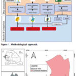
The system is designed to intervene in scenarios, where an autonomous AI agent – the ‘‘new driver’’ – encounters conditions too complex or unorthodox for autonomy alone to handle. We present here the first part of the paper. The concluding part will be publsihed in July issue
Kaya Kuru
School of Engineering and Computing, University of Central …
Restrictions for drones near critical infrastructure sites
The U.S. Federal Aviation Administration (FAA) has issued a proposed rule that would allow specific categories of critical infrastructure sites to apply for restrictions on drone operations around their facilities. Sixteen sectors would be eligible for restrictions including energy production, transportation systems, chemical facilities, water treatment plants, and defense …
The result from the GNSS processing method achieved the best performance in terms of absolute error evaluation
Mouhamadou Moustapha Mbacké Ndour
UFR-SI, University of Iba Der Thiam, Thiès, Senegal
Papa Matar Sylla
Holding Gueye, Dakar, Senegal
Alphousseyni Ndonky
UFR-SI, University of Iba Der Thiam, Thiès, Senegal
Babacar Faye
Simon & Christiansen Afrique (S.C.A), Dakar, Senegal
Abstract
The spatial representation of the Earth’s surface, as well …
White-label CAD solution in Japan
Pythagoras BV and Terra Drone have formed a strategic partnership to introduce a customized white-label software solution for the Japanese market. It combines Terra Drone’s SLAM and UAV technologies with Pythagoras’ CAD and point cloud processing software, creating an integrated platform tailored …

A holistic summary of important criteria needed for safe and successful flights
Tito Jun T. Tidula
A former UAV operator/ controller who operated both fixed wing and multirotor drones and is currently a faculty member in the Department of Agricultural and Biosystems Engineering, College of Engineering and Information Technology, University of Southern Mindanao, Kabacan, Cotabato, Philippines
Rezin G. …
SpaceX launches next-generation Italian COSMO-SkyMed satellite
The third satellite part of the COSMOSkyMed Second Generation (CSG) constellation, owned by the Italian Space Agency and the Italian Ministry of Defense, built by Thales Alenia Space, a joint venture between Thales (67%) and Leonardo (33%) and operated in orbit by Telespazio, a joint venture between Leonardo (67%) …
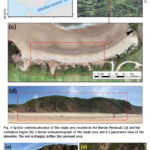
A case study on a beach and rocky cliff
Álvaro Gómez‑Gutiérrez
Instituto Universitario de Investigación Para el Desarrollo Territorial Sostenible, Universidad de Extremadura, Avda. de la Universidad S/N, 10003 Cáceres, Spain
Manuel Sánchez‑Fernández
Instituto Universitario de Investigación Para el Desarrollo Territorial Sostenible, Universidad de Extremadura, Avda. de la Universidad S/N, 10003 Cáceres, Spain
José Juan de Sanjosé‑Blasco
Instituto Universitario de Investigación …
UAVs assist forest officials
ideaForge Technology Limited deployed its Q6V2 UAV to support forest officials in preventing a potential human-elephant conflict in the Silli region of Jharkhand, India. The incident occurred when a herd of elephants strayed from the forest into nearby villages, creating panic among residents. Q6V2 UAV was launhced, …
New remote-sensing system maps Antarctic vegetation
Queensland University of Technology (QUT) researchers have developed an advanced remote sensing method for accurately detecting and mapping Antarctica’s delicate moss and lichen growth, the mainstays of the continent’s fragile ecosystems.
The research team also developed a way to survey Antarctica’s vegetation that is non invasive and will enable accurate surveys …


 (5.00 out of 5)