Articles in the GNSS Category
Moldova’s positioning system now uses Galileo
The MOLDPOS National Positioning System in Moldova has been integrated into the European Position Determination System (EUPOS), a pan-European GNSS augmentation service. The MOLDPOS navigational system uses both GPS and GLONASS, and now Galileo has been added. Creation of MOLDPOS was gradual. First, sites for placement of MOLDPOS stations …

The analysis performed in this report is solely his work and own opinion. State Program: U.S.A (G); EU (E); China (C) “Only MEO- SECM satellites”; Russia (R); Japan (J); India (I)
Narayan Dhital
Actively involved to support international collaboration in GNSS related activities. He has regularly supported and contributed to different workshops of the International Committee on …
RIN updates navigation system guide for small craft
The Royal Institute of Navigation Small Craft Group has released Version 2 of a free navigation guide for small and leisure craft. “Electronic Navigation Systems: Guidance for safe use on leisure vessels” is offered as a free digital download and as …

The analysis performed in this report is solely his work and own opinion. State Program: U.S.A (G); EU (E); China (C) “Only MEO- SECM satellites”; Russia (R); Japan (J); India (I)
Narayan Dhital
Actively involved to support international collaboration in GNSS related activities. He has regularly supported and contributed to different workshops of the International Committee on …

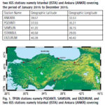
The study investigates ionospheric TEC variation over the Turkish region using 5 GNSS stations. The results showed that the overall TEC values display the trend of normal diurnal and annual TEC variations.
Kutubuddin Ansari
Faculty of Geodesy and Cartography, Warsaw University of Technology, Warsaw, Poland
Janusz Walo
Faculty of Geodesy and Cartography, Warsaw University of Technology, Warsaw, Poland
Selcuk Sagir
Department …

The analysis performed in this report is solely his work and own opinion. State Program: U.S.A (G); EU (E); China (C) “Only MEO- SECM satellites”; Russia (R); Japan (J); India (I)
Narayan Dhital
Actively involved to support international collaboration in GNSS related activities. He has regularly supported and contributed to different workshops of the International Committee on …

This paper has presented an investigation into the effects that solar radio bursts had on the GPS receivers of the International GNSS Service Network during Solar Cycle 24.
Manuel Flores-Soriano
Universidad de Alcalá, Space Weather Research Group, Department of Physics and Mathematics, Ctra. Madrid-Barcelona, Km. 33,600, Alcalá de Henares, 28805, Madrid, Spain
Abstract
Solar radio bursts (SRB) are a …

The analysis performed in this report is solely his work and own opinion. State Program: U.S.A (G); EU (E); China (C) “Only MEO- SECM satellites”; Russia (R); Japan (J); India (I)
Narayan Dhital
This article continues the monthly performance analysis of the GNSS constellation. Readers are encouraged to refer to previous issues for foundational discussions and earlier …


 (5.00 out of 5)