| Mapping | |
Maps-Connecting the Past, Present and Future
This paper is an extract from the author’s book Mapping: Past, Present and Future |
 |
|
The concept of mapping is shifting from its focus on land, slums, housing, transport, and infrastructure services to environment, ecology, climate change, disasters, health, jobs and heritage. The digital ecosystem and drones have drastically altered the concepts of mapping. The maps are not just the linear depiction of the past and present of but also its future.
Maps, also known as cartography, morphology and pictography, are a tactile form of spatial perception. They connect the past, present and future. They are the language of the surveyors, planners, architects, geographers, etc. Specialized maps include military, transport, railways, shopping, tourist, biodiversity, ecology, hydrology, and various other forms.
The maps can be the basis of discovery of space, co-sharing, cosensing, presencing, crystallising and generative dialogues in understanding the cross-cultural experiences, and exploring the environment- air, water, landscape and rocks.
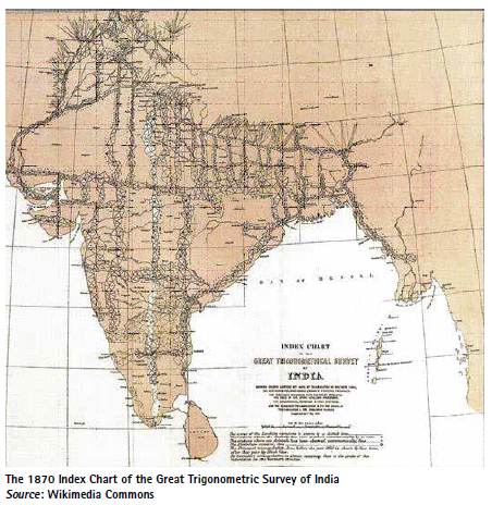
A map manifests space and time. Expressed in the form of a drawing, it is multivalent. It can be in the form of a sketch or can be drawn as a plan or a rendering, expressing the geographical features, physical environment, buildings, movement pattern, services and aesthetic qualities. It can be a vehicle for exploration or an instrument of planning and execution. A map provides an indispensable record of landform, terrain, land and contours, political and administrative boundaries and property ownership. India had been a pioneer and early proponent of surveys and mapping. The Survey of India established in 1767, developed a unique, scientific approach for surveying the entire subcontinent. In appreciation of its efforts, the Himalayas Peak XV in 1865 was named as Mount Everest after the eminent Surveyor General of India George Everest. The Great Trigonometrical Survey of India (1870) established a network of triangulation of the entire subcontinent as the basis for meridional and longitudinal chains of triangles and baselines with the help of Colby apparatus, spirit levels, astronomical pendulum and tidal stations for secondary triangulation of surveys (Fig. 1).
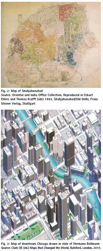
The map of Delhi and its environs drawn by Edward Weller (1857, Oriental and India Office Collection) has been meticulously redrawn by Eckart Ehlers and Thomas Krafft in 1993 (Fig.2). This is one of the most beautiful and detailed maps which has been my guide for unending walks in Shahjahanabad. This map helps to look at the city as the people-their emotions, customs, culture and relationships, much beyond the land use, buildings and legalities. One develops a humane perspective of the city where the ecology, economy, heritage and change co-exist.
The maps of Delhi narrate its rich history and evolution. These include ancient, colonial and Imperial Delhi, Post-Independence Delhi, Rehabilitation Colonies, Master Plans, Zonal Plans, Residential Schemes, Unauthorised Colonies, Resettlement Colonies, Villages, Work Centres, landscape and heritage.
In modern times satellite mapping systems are based on digitization, Geographic Information System (GIS) and Geographic Positioning System (GPS) which also help in tracking the weather, cyclones, floods, rivers, water bodies, geology and biodiversity. Three-dimensional maps have simplified the maps for general users. Hermann Bollmann style of maps are available for many cities all over the world for guidance of the tourists and others (Fig.3).
Geo-referencing and digitization of cadastral maps is being done under the Digital India Land Record Modernisation Programme (DILRMP). As per the Government of India, out of 6,56,793 villages, cadastral maps of 2,31,026 villages have been geo-referenced, and 1,17,38,272 maps have been digitized. In Delhi, land records of 207 villages have been digitized by the GNCTD. The Land and Development Office of the MOHUA have digitized 58,000 properties out of its 65,000 properties (TOI, 12th January 2023)
The Idea of Space and Place
According to Yu-Fu Tuan (Space and People, 1977), space is an abstract term for a complex set of ideas. People of different cultures differ in how they divide up their world, assign values to its parts, and measure them. Man organizes space so that it caters to his biological and social needs. The map is a combination of space and place which is differentiable into vertical -horizontal, top-bottom, front-back and right-left. The meaning of space often overlaps with that of place. Space is more abstract than place. It is location specific with spatial and visual qualities. These qualities include security, stability, openness, freedom, and coordinative character and a sense of place. Culture is a most significant factor which influences the organization of space and place. Sensory organ-kinesthesia sight, touch, smell greatly enrich our comprehension of the space. By movement a person acquires a sense of direction- forward-backwards, sideways, up and down. The visual space is dependent on flow of activity and other senses, which enrich spatial awareness. Three types of spaces exist- the mythical, pragmatic and abstract. The mythical space is usually based on faith, belief, and tradition, while pragmatic space is defined by economic activities. The human mind creates abstract spaces which embody their feelings, images and thoughts. The result is sculptural and architectural space composed of places and objects which give it a personality. In India, the cultures and religions have a gigantic influence in mythical mapping of the translucent cosmic world and the pragmatic, astronomical and geographical world. The earliest maps interpreted the Samsara, the cosmos, in the form of sun. moon and the countless rings of seas and continents, with Jambudwipa, Mount Meru at the centre (Fig. 4). To the South of this is the land of Bharatvarsha (India) bounded by the Himalayas and criss-crossed by great rivers. The metaphorical understanding of ancient Indian cosmological tradition is embedded in the concept of coexistence. The depiction of Bharatvarsha as Jambudvipa in Puranic cosmography manifests the harmonious coexistence i.e. ‘Vasudhaiva Kutumbakam – One Earth, One Family’. The seven-constituent elements of the state represent seven organs (saptanga)– (i) king (swami), (ii) council of minister (amatya), (iii) countryside (Janapada), (iv) Fort (durga), (v) Treasury (kosha), (vi) army (danda), and (vii) ally (mitra). These join together to bring material well-being (artha) and sensual pleasures (kama).

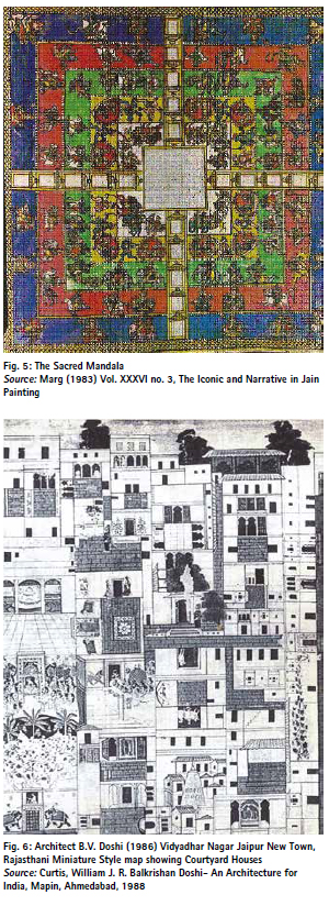
The traditional manuscripts are illustrated with the mandala as metaphors of space and place adorned by the sacred gods, goddesses, flora and fauna, seers, pupils, devi-devatas, kings, common people, festivals-games, music-arts, palaces-hutments, etc. (Fig 5). A place achieves a concrete reality through all the senses with an active and reflective mind. It gives a characteristic and symbol making to a place by its setting, topography, skyline, odors and noise.
Some modern architects and planners have experimented with new forms of mapping and drawings, which like antique pictorial maps, display the 3-dimensional spaces on 2 D maps. B.V. Doshi developed this kind of map in his Vidyadhar Nagar Jaipur New Town, which connotes Rajasthani miniature style art (Fig. 6). Morphology and morphogenesis are the terms which are commonly adopted by the surveyors, architects and planners. These terms are rooted in morpho- biology, the study of structure, forms and topography. The geographic approach of mapping divides terrains with territories indicating domains and political controls. However, birds, animals and fish don’t know about these lines. The indigenous cultures also challenge such geographic imaginings and view the spaces differently. A classic example is Harry Beck’s 1931 map of the London Tube. He ignored the layout of the city, its landmarks, roads, the River Thames and even the cardinal points. Nothing was to scale, stations were spread apart, regardless of the distances between them. The transit lines were colour coded with straight lines that turned only at 45 and 900 angles. The stops give a sense of minutes rather than the miles. It was a clear, simple and easy to understand map for everyone. Beck’s diagram has become a prototype of metro map around the World, including Delhi, Mumbai, Kolkata and other cities.
The perception of space- whether it is physical, digital, topological, quantum or hyper-requires interactive and cognitive processes by which the onlooker becomes aware of the relative positions of the things around them. The human mind makes sense of space and their relationship with neuroscience, technology and machine learning. These narratives comprise multiple layers of history and visualization. This may lead to a new phase of data poetics that describes the lyrical traces of human memories, such as photographs, maps, documents and sound. The digital age is changing the way we understand and create visual stories in urban space. GPS, Smart Phone Apps, long distance communication and internet have changed the concept of mapping and have vanished the boundaries of geography. Cyber space and new channels of communications have shrunk the world, distances and relationships.
Maps of Delhi
Delhi is an archetypical paradigm which does not adhere to a single tradition. It has been an active laboratory of hybrid cultures. According to Pilar Maria Guerrierie ‘Delhi has played an active role in the complex process of hybridisation in both the pre and post-independence periods, developing its own character as oppose to nearly accepting what was brought from abroad. Both periods have been characterised by a resilience and continuing compromise between indigenous and foreign elements’.
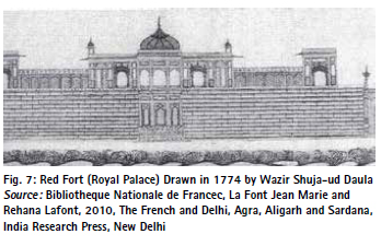
A prolific legacy of maps, drawings, lithographs and pictures of Delhi are available from different sources. One of the earliest of them is the Gentil Album (after Jean Baptiste Gentil, 1726-1799) of Palais Indiens (1774) at the Bibliotheque Nationale, Paris. (Fig. 7).
Daniel’s aquatints of Delhi (1795) have been extensively published. The works of Delhi artists during 1830- 55 who worked for Thomas Theophilus Metcalfe, James Skinner and William Fraser provide interesting glimpses of Delhi. 1836-1846 had been a golden period during which Mazhar Khan painted most detailed views of Delhi, which are with the British Library, London.
In 1846-47 East India Company in collaboration with the Survey of India produced maps of Shahjahanabad. Syed Ahmed Khan’s Asar al Sanadid (1852) provides a detailed record of Delhi’s monuments. During 1865 to 1875 French artist Louis Rousselet produced the Inde des Rajahs which had beautiful views of Chandni Chowk, Tughlakabad, Kotwali in Chandni Chowk, Qutab Minar, etc. The privileged relationship between the French and the Mughals started during the reign of Jahangir (1606-28) with Augustinede Bourdeux and Thomas Roe. It was followed by Bernier, Tavernier, Law de Lauriston, Madec, Jacquemont and Rousselet. They were great collectors of paintings, maps and drawings revealing the culture, geography, and morphology of their times.
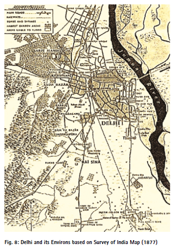
During 1873, 1877 and 1913, the Survey of India published up to date maps of Delhi (Fig.8). In 1858 Felice Beato photographed Delhi, which recorded its unique charm. 1911 onwards the Wilson Survey of Old Delhi recorded its detailed morphology. During 1916-19 Zafar Hasan sketched the significant historical buildings and monuments of Delhi. During 1912-31 thousand of drawings surveys and designs for Imperial Delhi were prepared by Edwin Lutyens, Herbert Baker, T R Russel, Shoosmith and various other architects, most of which are preserved by the Central PWD, New Delhi. The records of Delhi Improvement Trust (1937- 57) were held by its successor Delhi Development Authority, some of which were transferred to the Municipal Corporation of Delhi. Town and Country Planning Organisation is another repository of drawings, such as Wilson Survay and many other survey maps of Delhi for preparation of Delhi Master Plan.
Besides government organisations-National Archives, SOI, ASI, TCPO, CPWD, L&B Department of GNCTD, Land and Development Office (MHOUA), DDA, NDMC and MCD, a rich tranche of maps, drawings and visuals of Delhi are available with the Alkazi Collection, Getty Images, INTACH, Eicher (Maps of Delhi), private surveyors and photographers, individuals and publishers. Notable among these are the Maps of Delhi (Guerrieri, 2017, Niyogi), Maps of India (Lahri, 2012, Niyogi). All these maps are valuable resources which need to be preserved, digitized and published for posterity.
Apart from field surveying, maps are now available through internet, satellite, geographic information system and aerial photography. New technologies are emerging which also map hidden/ underground information (like service lines, minerals, geology, sub-soil water, temperature, etc.). These have greatly enhanced understanding of the physical realities of the world and help in making the proposals for planning and development.
Diagrams of Historical Geography
Stephen Legg in his book Spaces of Colonialism, (Blackwell, Oxford, 2007) provides a detailed analysis of the historical geography of colonial Delhi. He combined empirical analysis and mapping with the diagrams of the biopolitical Delhi. He refers to Faucault (1978) term ‘governmentality’, which is an intersection of power, analytics and govermentalisation that seeks to regulate the population, development and urban form.
According to Stephen Legg, New Delhi marked the emergence of the two complimentary but different forms of hierarchy: Spatial and Social. The physical grid also defined the norms of bungalow size, plot size, street amenities, design/elevation and maintenance. While the focus was on the new city, the Old City was not ignored. Viceroy Harding in his address to the Delhi Municipal Committee (DMC) on 23rd December 1912 stated ‘you must become a Capital city, not in name, but in fact; you must make your town a model of municipal administration, your institutions, your public buildings, your sanitation must be an example to the rest of India. To attain these results will demand on your part much sustained efforts, and the cultivation of a high sense of public duty. I can promise that the Government of India will be prepared to sustain you in those efforts by every means in its power. We shall not forget when building a New Delhi outside your walls, that there exists an Old Delhi besides us which claims our interest and our assistance.’
Geoffrey de Montmorency, who was responsible for the capital transfer program, addressed the question of Delhi’s expansion in 1912.The Deputy Commissioner Lt. Colonel Montagu William Douglas in 1913 also wrote to the Chief Commissioner about increasing pressure on Delhi. He pleaded that an Improvement Trust must be created in Delhi. He prepared a report for acquisition of land for Imperial Delhi where he also proposed acquisition of land for New Cantonment, Western Extension, South Extension and North Extension. These lands were utilized for various decongestion schemes of Old City even before the creation of the Delhi Improvement Trust (1937) and for refugees’ townships and many other schemes undertaken after Independence in 1947.
Mandala- The Morphology of Indian City
The traditional maps were based on the vedic knowledge as contained in the canons of Vastushashtra and Mansara, the treatise on town planning and architecture. As a basic principle, a city manifests a micro-cosm within the broad cosmic cycle, like the planets in the astrological chart. A system of ashtha (8), Navgrah (9 planets), 24 matrika pithas, etc. was devised as a numerical symbolism and for orientation and linkages of the settlement system.
The five elements of nature were also signified by the settlement system. It was perhaps this that the five cities namely, Indraprastha, Bagpat, Panipat, Sonipat and Tilpat signified the 5 elements of nature, viz. air, earth/vegetation, water, fire and space. The form of a city was derived on the principle of Vãstupurush Mandal. It established an interrelationship of physical form of a settlement with the spiritual, cosmic behavioural system. It determines the basic form, its location and orientation of various functions in a settlement. As in music, the basic principles can create an infinite range of compositions, likewise the principles of Mansara can be applied to innumerable forms of a settlement. There is nothing such as an ideal city or an ideal music composition.
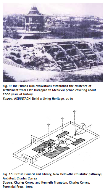
The settlements usually had a coherent and balanced set of forces, whether its location, zoning and functional classification. It is thus not a surprise that the mandala form of the Indraprastha, and Shahjahanabad coincide with the Vedic principles. The excavations of the Purana Qila have yielded painted grey earthenware which dates to 1000 BC (Fig. 9). The village of Indrapat, which is derived from Indraprastha can be identified in the Survey of India Maps of Delhi, which was cleared along with other villages during the building of New Delhi (1912-20).
It is quite amazing that the Imperial Delhi planned by Edwin Lutyens was located on the western bank of the River Yamuna, like Indraprastha and Shahjahanabad. The Viceroy house (Palace Complex) had been sited on top of the Raisina hill, overlooking the river Yamuna. It is facing the east, so as to get cool breeze and morning glory of rising sun. Two major roads, namely Kingsway (Rajpath) and Queensway (Janpath), provide major linkages to various functions. At the crossing of these two roads, socio-cultural institutions were located, which is the Brahmasthan in the Vãstupurush Mandal. Lutyens’ New Delhi is perhaps an unintended revival of the IndoRoman heritage of city design. The principles of Mandala have again reappeared in some landmark projects, such as the British Council Library Building in New Delhi (Fig. 10).
Urban Mapping for Planning
A map can be defined as representation of earth’s pattern as a whole or part on a plane surface with conventional signs, drawn to a scale and projections so that it corresponds to the actual terrestrial position. The survey maps (Survey of India, NRSA, Satellites, Google Earth, Total Station Surveys, Theodolite Plane Table, Drone, etc.) form the basis of planning. The urban maps not only reflect the existing surveys, but also indicate land use, status of ownership, roads and services, status of encroachments and administrative domain. These have a legal status which provides evidence of land ownership, land use, unauthorised construction, etc. This is particularly crucial in view of the court cases against the encroachments, unauthorised construction and non-conforming land use or their regularisation policies.
The urban maps are superimposed with ground surveys, administrative/ revenue maps, land ownership, satellite imageries and other surveys, such as environmental, groundwater, etc. These maps are enlarged or reduced to enable superimposing variety of land information on the same scale (preferably 1:4000, which corresponds to revenue maps 1″ = 330 feet). These provide the base maps and spatial information required for planning of the land , zoning, land use, parks/open spaces, transportation networks, infrastructure services, housing, slum rehabilitation, etc. The scale of map depends upon the size of the planning area and the coverage and extent of the information to be shown.
The scale of maps for different types of planning exercise at various levels can be selected as per the details required for planning. For planning purpose, a map will have the following characteristics:
• Geometry, positioning and height: The geometry of a map is achieved through a set of ground control points, called stations and levelling Benchmarks (BMs). These stations may have the utmost accuracy of a geodetic station. BMs are, presently, being provided by the Survey of India (SOI). The position of these stations is given in the form of coordinates expressed in terms of latitude and longitude. In most of the cases, accurate information about the stations and the BM’s is restricted.
• Contents of a map: The earlier technology of the ground-based methods (plane tabling, etc) has been replaced by the aerial photography(photogrammetry) and satellite imagery. The resolution of the modern-day satellites has reached a level of one metre. This enables the map to be high-resolution with better details.
• Updating the map: The satellite imagery is of great help in updating the maps as the satellite visits the same spot at regular intervals.
• Scale: The scale of a map can be chosen according to its purpose, which may vary from 1:50,000 (regional/district/urban plans) to 1:100 (architectural drawings).
• Size of the Map The size of the map is largely influenced by statutory requirements of the plan. However, availability of infrastructure for mapping also influences the decision of map size. To standardise the size of the maps, Bureau of Indian Standards (BIS) has issued the guidelines.
Future of Mapping
The power of maps is depicted by spatial manifestation that transcends architectural form, materiality and urban order or disorder, overlaying the terra nullius. The mapping is undergoing a radical transition with new forms of technological, geographical, social, economic and ecological associations.\
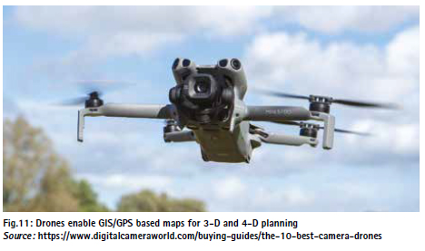
Recently, we have witnessed the wars in Middle East, Iran and Israel, Ukraine and Russia as the drones have emerged the most fatal ammunition, where making the aircrafts redundant. Likewise, drones have revolutionised surveying and mapping, which are rapid, economical and easier to use (Fig. 11). These are replacing conventional mapping and allow dynamic, real-time interactions among the users.
Artificial Intelligence (AI) powered maps and toolbox help to compute and analyse the data in real-time for planning, implementation and coordination. This is leading to a new phase of mapping that celebrates the human memories, photographs, documents and information in creating the future urban space.
References
Blake, Stephen P., Shahjahanabad; The Sovereign City in Mughal India. Foundation Books, New Delhi, 1993
Clark, John O.E., Maps that Changed the World, Batsford, London, 2015
Collette Calliat and Ravi Kumar, , The Jain Cosmology, Ravi Kumar Publication, Basel, Paris, 1981
Correa, Charles and Framton, Kenneth, Charles Correa, Perrinial Press, 1996
Curtis, William, JR, Balkrishan Doshi, An Architecture for India, Mapin, Ahmedabad, 1988
Delhi Development Authority, Master Plans for Delhi, DDA, New Delhi, 1962, 2001, 2021
Delhi Improvement Trust (1937-57). Administrative Reports of Delhi Improvement Trust for 1938-39 to 1956-57, DIT, Delhi
Doshi, Balkrishan, Architecture for the people, Vitra Design Museums, Reine and Vastushilp Foundation, Ahmedabad, 2019
Eicher Delhi City Map, Eicher Goodearth, New Delhi, 2001
Ehlers, Eckart and Thomas Kraft., Shahjahanabad: Old Delhi: Tradition and Colonial Change. Manohar, New Delhi, 2003
Frykenberg, R. E (ed.) Delhi Through the Ages: Essays in Urban History, Culture and Society, OUP, Delhi, 1986
Guerrieri, Pilar, Maria, Neglecting Cultures, Delhi Architecture and Planning from 1912 to 1962, Oxford University Press, New Delhi, 2018
Guerrieri Pilar, Maria, Maps of Delhi, Niyogi Books, New Delhi, 2017
INTACH, Delhi A Living Heritage, INTACH New Delhi, 2010
Jain, A.K., Mapping Delhi: Past, Present and Future, Synergy Books, New Delhi, 2026.
Lahri, Manosi, Mapping India, Niyogi Books, New Delhi, 2012
Lafont, Jean Marie & Rehana Lafont, The French and Delhi, Agra, Aligarh and Sardana, India Research Press, New Delhi, 2010
Legg, Stephan, Spaces of Colonialism, Blackwell Publisher, Oxford, 2017
Losty, J P. 3600 Mazhar Ali Khan, View from the Lahore Gate, Roli Books, New Delhi, 2011.
Marg, Vol. XXXVI, No.3, The Temples and Narrative in Jain Paintings, Marg, Mumbai, 1983
Yi-Fu Tuan, Space and People, University of Minnesota Press, 1977


 (1 votes, average: 5.00 out of 5)


Leave your response!