Volume 22, Issue 5, May 2026 |
|
|||||||||||||||||||||||||||||||||||||
|
|||||||||||||||||||||||||||||||||||||
Volume 22, Issue 4, April 2026 |
|
|||||||||||||||||||||
On August 28, 2023, Globalstar, Inc. entered into a Launch Services Agreement by and between the Company and Space Exploration Technologies Corp. and certain related ancillary agreements (the “Launch Services Agreements”), providing for the launch of the first set of the satellites the Company is acquiring pursuant to its previously disclosed Satellite Procurement Agreement. The …
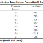
Land tenure security is a critical government service that has repercussions on agricultural productivity, housing development, business investment, and the development of urban areas. The present study presents a cost-benefit analysis of tenure security …

The results conclude that both Indonesia and Malaysia still face land registration issues
Ricco Survival Yubaidi
Faculty of Law, Universiti Kebangsaan Malaysia, Malaysia
Mazliza Mohamad
Faculty of Law, Universiti Kebangsaan Malaysia, Malaysia
Saidatul Nadia Abd Aziz
Faculty of Law, Universiti Kebangsaan Malaysia, Malaysia
Abstract
Every country has its land policy system. Indonesia employs deeds registration which refers to the Basic Agrarian Law (BAL) …

In this article, the results obtained assessing the Galileo HAS performance at high latitudes in a period of intense ionospheric activity during the ongoing 25th solar cycle are presented
Melania Susi
Ph.D. in Engineering Surveying and Space Geodesy from the University of Nottingham, UK, where she was also a Marie Curie fellow. After being a scientific technical …
The Galileo OS has been upgraded with three new features added to its I/NAV message, one of the four message types broadcast by Galileo satellites. Collectively referred to simply as I/NAV improvements, these features are now available to all Galileo Open Service users.
Starting on 12 August 2023, the gradual process of upgrading the operational Galileo FOC constellation satellites has …


 |
Introduction To Geodesy... |
 |
This comprehensive book charts the course of NSDI journey in India, which is still continuing... |
 |
“The problem of GNSS disruptions will never be solved, but it can be much better managed”
Dana A. Goward |


 (5.00 out of 5) (5.00 out of 5) (5.00 out of 5) (5.00 out of 5)
