Volume 22, Issue 6, June 2026 |
|
||||||||||||||||||||||||||||||||||
|
||||||||||||||||||||||||||||||||||
Volume 22, Issue 5, May 2026 |
|
||||||||||||||||||||||||
The Royal Institution of Chartered Surveyors (RICS) has published the first global professional standard for the responsible use of artificial intelligence (AI) in surveying practice – a decisive move to guide the profession through the rapid evolution of AI technologies.
Set to take effect on 9 March 2026, the new standard sets out mandatory requirements and …
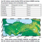
The study investigates ionospheric TEC variation over the Turkish region using 5 GNSS stations. The results showed that the overall TEC values display the trend of normal diurnal and annual TEC variations.
Kutubuddin Ansari
Faculty of Geodesy and Cartography, Warsaw University of Technology, Warsaw, Poland
Janusz Walo
Faculty of Geodesy and Cartography, Warsaw University of Technology, Warsaw, Poland
Selcuk Sagir
Department …

The analysis performed in this report is solely his work and own opinion. State Program: U.S.A (G); EU (E); China (C) “Only MEO- SECM satellites”; Russia (R); Japan (J); India (I)
Narayan Dhital
Actively involved to support international collaboration in GNSS related activities. He has regularly supported and contributed to different workshops of the International Committee on …

The Central and State governments have committed the policy of Jahan Jhuggi-Wahan Makaan, that is In-Situ Slum Resettlement in Delhi, replicating the Dharavi Model of Mumbai. While the policy is already mandated in the Delhi Master Plan, its implementation involves putting in place people centric, evolutionary and support-based tools that are more longitudinal and avoid …
NextNav and Oscilloquartz, a division of Adtran, have partnered to demonstrate how 5G-powered terrestrial positioning, navigation, and timing (PNT) technology combined with Oscilloquartz’s established synchronization systems can serve as a scalable complement and backup to GPS. The initiative aims to maintain the operation of critical infrastructure, such as data centers, utilities, and emergency services, during GPS …


 |
Introduction To Geodesy... |
 |
This comprehensive book charts the course of NSDI journey in India, which is still continuing... |
 |
“The problem of GNSS disruptions will never be solved, but it can be much better managed”
Dana A. Goward |


 (5.00 out of 5) (5.00 out of 5) (5.00 out of 5) (5.00 out of 5)
