
Volume 22, Issue 2, February 2026 |
|
||||||||||||||||||||||||||||||||||
|
||||||||||||||||||||||||||||||||||
Volume 22, Issue 1, January 2026 |
|
|||||||||||||||||||||
State-of-art regional geodesy centre on the cards at MNNIT
A state-of-the-art Regional Geodesy Centre (RGC) would soon be set up at Motilal Nehru National Institute of Technology (MNNIT), Prayagraj. Working in close coordination with the countryʼs first National Geodesy Centre (NGC) functioning in Indian Institute of Technology (IIT)-Kanpur, the regional centre would undertake studies in …
Hitachi launches Lumada Inspection Insights
Hitachi, Ltd. has launched Lumada Inspection Insights, its end-to-end portfolio of digital solutions for the inspection, monitoring, and optimization of critical assets. It enables customers to automate asset inspection, support sustainability goals, improve physical security, and reduce risks and impacts related to storms or fires by using powerful artificial intelligence …
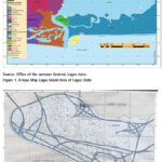
The aim of this research is to produce a new and updated map Lagos Island Local Government Area, Nigeria and document changes that have occurred over time
Leonard Michael Onyinyechi Aminigbo
Department of Geography and Environmental Management, Rivers State University, Portharcourt, Nigeria
Abstract
The scope of the research work comprised the planning and preliminary data requirement analyses, acquisition of …

The results of the study conducted in Perth, Australia show distinct advantages of using spatial statistics at the site investigation scale, and for measuring multiple elements not just potential contaminants
Andrew W. Rate
School of Agriculture and Environment, The University of Western Australia, Australia
Abstract
Public recreation areas in cities may be constructed on land which has been contaminated …

The expected results will be a contribution to the assessment of natural risk and seismic hazard in the study area and will have a positive impact for the sustainable development of the region
Nikolay Dimitrov
Assoc Professor, Head of Department Geodesy, National Institute of Geophysics, Geodesy and Geography, Bulgarian Academy of Science, Bulgaria
Introduction
The study of recent crustal …

 |
Introduction To Geodesy... |
 |
This comprehensive book charts the course of NSDI journey in India, which is still continuing... |

 |
“A world of multi-GNSS brings faster and more innovations“
Sherman Lo |


 (5.00 out of 5) (5.00 out of 5) (5.00 out of 5) (5.00 out of 5)
