Volume 22, Issue 5, May 2026 |
|
|||||||||||||||||||||||||||||||||||||
|
|||||||||||||||||||||||||||||||||||||
Volume 22, Issue 4, April 2026 |
|
|||||||||||||||||||||
Orbital Insight, specialising in Geospatial intelligence, and Carahsoft Technology Corp., announced a partnership. Under the agreement, Carahsoft will serve as Orbital Insight’s Master Government Aggregator.
This makes the company’s AI-powered geospatial data analytics available to the Public Sector through Carahsoft’s reseller partners, and Information Technology Enterprise Solutions – Software 2 (ITES-SW2), NASA Solutions for Enterprise-Wide Procurement …
RoboSense, a world-leading provider of Smart LiDAR Sensor Systems, has announced the launch of its first automotive-grade solid-state LiDAR perception solution for L4 autonomous driving, the RS-Fusion-P6 (P6). With advanced software and hardware support from RoboSense, the P6 provides precise and intelligent environmental perception capabilities, enabling autonomous vehicles to navigate through complex driving scenarios with …
The McMillon Innovation Studio has partnered with DroneUp, LLC, a leading autonomous drone delivery platform and drone services provider, to evaluate opportunities to expand DroneUp’s operations, including on college campuses.
The McMillon Innovation Studio, part of the U of A’s Office of Entrepreneurship and Innovation, offers an opportunity for student design and product teams to develop human-centered …
Optelos, the supplier of visual data management and analysis software for cell tower inspection applications, and Pathwave, the provider of safety and job closeout software for telecom crews, announced the technology partnership.
The partnership will allow carriers, asset owners and contractors to combine the latest drone data captures and digital twins with safety compliance and closeout …
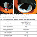
The present paper shows the prototype results of the antenna designed in the scope of the MAGICA project providing a multi-constellation and multi-band (L1/E1, L5/E5 and E6) solution for the automotive industry
Marco Antonio Vélez
IDNEO Technologies, S.A.U, Carrer Rec de Dalt, 3, 08100 Mollet del Vallès (Barcelona), Spain
Jose Javier Vicente
IDNEO Technologies, S.A.U, Carrer Rec de Dalt, …


 |
Introduction To Geodesy... |
 |
This comprehensive book charts the course of NSDI journey in India, which is still continuing... |
 |
“The problem of GNSS disruptions will never be solved, but it can be much better managed”
Dana A. Goward |


 (5.00 out of 5) (5.00 out of 5) (5.00 out of 5) (5.00 out of 5)
