
Volume 22, Issue 2, February 2026 |
|
||||||||||||||||||||||||||||||||||
|
||||||||||||||||||||||||||||||||||
Volume 22, Issue 1, January 2026 |
|
|||||||||||||||||||||
Hesai Technology has announced a partnership with Webasto, the leading global automotive supplier of roof systems. Hesai will provide automotive lidar sensors to Webasto for its Roof Sensor Module for passenger cars with ADAS.
Hesai’s AT128 long range lidar has been integrated in Webasto’s current Roof Sensor Module, which features several cameras and lidars. Webasto system …
Getech, a world-leading locator of subsurface resources, has announced an agreement with Planet, a leading provider of daily global satellite imagery and geospatial solutions, to join its “Orbit” partner programme.
Becoming a Planet partner enables Getech to access Planet’s wealth of earth observation data for use in data-led geoenergy exploration projects across sectors as diverse as mineral …
On August 28, 2023, Globalstar, Inc. entered into a Launch Services Agreement by and between the Company and Space Exploration Technologies Corp. and certain related ancillary agreements (the “Launch Services Agreements”), providing for the launch of the first set of the satellites the Company is acquiring pursuant to its previously disclosed Satellite Procurement Agreement. The …
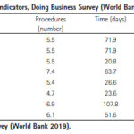
Land tenure security is a critical government service that has repercussions on agricultural productivity, housing development, business investment, and the development of urban areas. The present study presents a cost-benefit analysis of tenure security …

The results conclude that both Indonesia and Malaysia still face land registration issues
Ricco Survival Yubaidi
Faculty of Law, Universiti Kebangsaan Malaysia, Malaysia
Mazliza Mohamad
Faculty of Law, Universiti Kebangsaan Malaysia, Malaysia
Saidatul Nadia Abd Aziz
Faculty of Law, Universiti Kebangsaan Malaysia, Malaysia
Abstract
Every country has its land policy system. Indonesia employs deeds registration which refers to the Basic Agrarian Law (BAL) …

 |
Introduction To Geodesy... |
 |
This comprehensive book charts the course of NSDI journey in India, which is still continuing... |

 |
“A world of multi-GNSS brings faster and more innovations“
Sherman Lo |


 (5.00 out of 5) (5.00 out of 5) (5.00 out of 5)
 (4.94 out of 5)
