Volume 21, Issue 4, April 2025 |
|
|||||||||||||||||||||||||||||||
|
|||||||||||||||||||||||||||||||
Volume 21, Issue 3, March 2025 |
|
|||||||||||||||||||||
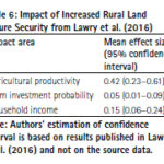
Land tenure security is a critical government service that has repercussions on agricultural productivity, housing development, business investment, and the development of urban areas. The present study presents a cost-benefit analysis of tenure security in Sub-Saharan Africa. Readers may recall that we published the first part of the study in September 2023 issue of Coordinates. …
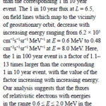
In this study, an extreme value analysis is condcuted of the daily average relativistic electron flux in GPS orbit as a function of position and energy using data from the US NS41 satellite from 10 December 2000 to 25 July 2020
Nigel P. Meredith
British Antarctic Survey, Natural Environment Research Council, Cambridge, United Kingdom
Thomas E. Cayton
Santa Fe, …
According to Rokubun — a Spanish company that designs accurate and scalable navigation solutions based on GNSS — released a library solution for decoding and processing Galileo Open Service Navigation Message Authentication (OSNMA) for embedded platforms.
The solution is part of the Horizon Europe BANSHEE project, for which Rokubun served as the coordinating, is EU-funded, and is supported by …
The European Union Aviation Safety Agency (EASA) has certified Madrid-based European Satellite Services Provider (EESP) as a pan-European communication services provider for Iris data link services.
Iris, a project supported by the European Space Agency (ESA) and various European partners, aims to develop a satellite-based air-ground communication system to enhance air traffic management. By 2028, Iris …
The Australian and New Zealand governments, with support from FrontierSI, are conducting a survey with original equipment manufacturers (OEMs) to identify the opportunities and barriers for integrating Southern Positioning Augmentation Network ( SouthPAN) signal support in GNSS chips, devices and equipment.
SouthPAN is a Satellite-Based Augmentation System (SBAS) in the Southern Hemisphere and provides improved positioning and navigation services …

 |
This comprehensive book charts the course of NSDI journey in India, which is still continuing... |
 |
Introduction To Geodesy... |

 |
“In Japan, navigation technology is now mainly based on satellite positioning technology”
Kiyokazu Minami |
 |
Takeyasu Sakai Member, Leader of GPS/GNSS research group, Japan Institute of Navigation |


 (5.00 out of 5) (5.00 out of 5) (5.00 out of 5) (5.00 out of 5)
