Volume 21, Issue 3, March 2025 |
|
|||||||||||||||||||||||||||||||
|
|||||||||||||||||||||||||||||||
Volume 21, Issue 2, February 2025 |
|
|||||||||||||||||||||
Hesai Technology announced an ADAS lidar design win with Neta Auto’s new series production vehicle. Hesai will supply ultra-high resolution long-range lidar AT128 for Neta Auto’s upcoming vehicle model which is expected to launch in the first half of 2025.
Neta Auto is a leader in the smart EV industry. The company is committed to making …
Phase One, a company in medium- and large-format digital cameras and imaging systems, introduces PAS Pana. The PAS Pana is useful for country-wide area mapping providing unmatched performance and precision.
PAS Pana is a seven-camera wide-field system that redefines the landscape of aerial mapping precision and effectiveness. With a strategic configuration comprising five RGB cameras equipped with 150 mm lenses, and two NIR cameras with 70 mm lenses, PAS Pana reaches a total swath …
The United States Space Force’s Space Systems Command (SSC) has a specialized branch responsible for certifying GPS accuracy called the GPS Certification Branch. It is a specialized team within SSC that is responsible for certifying the hardware, software, and firmware used in GPS-based systems.
The certification process conducted by SSC’s GPS Certification Branch involves the evaluation of …
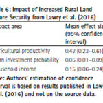
Land tenure security is a critical government service that has repercussions on agricultural productivity, housing development, business investment, and the development of urban areas. The present study presents a cost-benefit analysis of tenure security in Sub-Saharan Africa. Readers may recall that we published the first part of the study in September 2023 issue of Coordinates. …
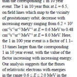
In this study, an extreme value analysis is condcuted of the daily average relativistic electron flux in GPS orbit as a function of position and energy using data from the US NS41 satellite from 10 December 2000 to 25 July 2020
Nigel P. Meredith
British Antarctic Survey, Natural Environment Research Council, Cambridge, United Kingdom
Thomas E. Cayton
Santa Fe, …

 |
This comprehensive book charts the course of NSDI journey in India, which is still continuing... |
 |
Introduction To Geodesy... |

 |
“In Japan, navigation technology is now mainly based on satellite positioning technology”
Kiyokazu Minami |
 |
Takeyasu Sakai Member, Leader of GPS/GNSS research group, Japan Institute of Navigation |


 (5.00 out of 5) (5.00 out of 5) (5.00 out of 5) (5.00 out of 5)
