
Volume 22, Issue 2, February 2026 |
|
||||||||||||||||||||||||||||||||||
|
||||||||||||||||||||||||||||||||||
Volume 22, Issue 1, January 2026 |
|
|||||||||||||||||||||
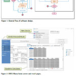
“GNSS Ghana” Software (GGS), a GNSS standalone Windows-based application with a modern user-friendly interface was developed for geodetic applications
Gameti Charles
Department of Geomatic Engineering, Kwame Nkrumah University of Science and Technology (KNUST), Kumasi, Ghana
Acheampong Akwasi Afrifa
Department of Geomatic Engineering, Kwame Nkrumah University of Science and Technology (KNUST), Kumasi, Ghana
John Ayer
Department of Geomatic Engineering, Kwame Nkrumah University …
Nexar announced that it has achieved a dramatic 40x reduction in the cost of real-time mapping by leveraging cutting-edge technologies, edge AI, change detection, and crowdsourcing.
As a result, Nexar’s CityStream Live platform is making real-time mapping data more accessible to the mobility industry than ever before.
Real-time mapping has become increasingly crucial, particularly as an enabler …
Cities and counties now have a powerful new tool at their disposal with the release of the Digital Twin Base Map.
Developed by leading tech firm The Sanborn Map Company (Sanborn), this innovative technology sets a new standard for urban analysis, implementation of Digital Cities, navigation, and planning with a fundamental transformation from a 2D map …
CGI, a global IT and business consulting services firm, in partnership with Ordnance Survey, has developed an initiative designed to remotely detect sewage overspill events from space.
The project will utilise a newly created artificial intelligence (AI) model that can predict with high levels of accuracy the conditions most often associated with pollution events.
This is the …
Innoviz Technologies announced that it is on track to deliver LiDAR technology for CARIAD’s future advanced driver assistance systems (ADAS) and automated driving functions.
Since naming Innoviz as its direct LiDAR supplier, Innoviz and CARIAD have been working closely to understand unique engineering needs and to optimize processes that will support the use of LiDAR-enabled ADAS …

 |
Introduction To Geodesy... |
 |
This comprehensive book charts the course of NSDI journey in India, which is still continuing... |

 |
“A world of multi-GNSS brings faster and more innovations“
Sherman Lo |


 (5.00 out of 5) (5.00 out of 5) (5.00 out of 5) (5.00 out of 5)
