Volume 21, Issue 4, April 2025 |
|
|||||||||||||||||||||||||||||||
|
|||||||||||||||||||||||||||||||
Volume 21, Issue 3, March 2025 |
|
|||||||||||||||||||||
Denmark’s GomSpace has partnered with Portugal’s Neuraspace to add their space traffic management to its hands-off operations platform (HOOP) for satellite operators. The combination of both will provide improved safety and further cost reduction to GomSpace’s customers.
The partnership also showcases that Neuraspace’s AI-based space traffic management, in addition to enabling operators to directly monitor their …
Pix4D and ProStar Holdings have announced a strategic partnership. This collaboration combines Pix4D’s advanced 3D modeling capabilities with ProStar’s PointMan® platform to support the next evolution in augmented reality for critical underground infrastructure.
Pix4D and PointMan represent a significant advancement in the digital transformation of underground infrastructure mapping. This partnership is groundbreaking because it delivers a …
Juvare, the global leader in crisis and emergency management technology, and ICEYE, the industry pioneer in synthetic aperture radar (SAR) satellite data, have announced a strategic partnership designed to deliver unprecedented situational awareness and actionable insights to emergency management agencies, insurers, and government organizations worldwide. Through this collaboration, ICEYE’s high-resolution, all-weather satellite solutions will be …
The General Authority for Survey and Geospatial Information (GEOSA) and the Singapore Land Authority (SLA) officially launched the outcomes of their cooperation project to develop and manage the geospatial system. The partnership is part of GEOSA’s broader effort to establish a robust national geospatial infrastructure, aligning with global best practices to enhance the positive and …
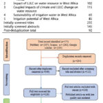
This study aims to review the existing literature on the impacts of climate, and LULC changes on the sustainability of irrigation water in West Africa.
Gemechu Fufa Arfasa
Department of Natural Resource Management, Wolaita Sodo University, Sodo, Ethiopia
Ebenezer Owusu-Sekyere
Faculty of Natural Resources and Environment, Department of Environment and Sustainability Sciences, University for Development Studies, Tamale, Ghana
Dzigbodi Adzo …

 |
This comprehensive book charts the course of NSDI journey in India, which is still continuing... |
 |
Introduction To Geodesy... |

 |
“In Japan, navigation technology is now mainly based on satellite positioning technology”
Kiyokazu Minami |
 |
Takeyasu Sakai Member, Leader of GPS/GNSS research group, Japan Institute of Navigation |


 (5.00 out of 5) (5.00 out of 5) (5.00 out of 5) (5.00 out of 5)
