
Volume 22, Issue 2, February 2026 |
|
||||||||||||||||||||||||||||||||||
|
||||||||||||||||||||||||||||||||||
Volume 22, Issue 1, January 2026 |
|
|||||||||||||||||||||
Optelos, the supplier of visual data management and analysis software for cell tower inspection applications, and Pathwave, the provider of safety and job closeout software for telecom crews, announced the technology partnership.
The partnership will allow carriers, asset owners and contractors to combine the latest drone data captures and digital twins with safety compliance and closeout …
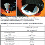
The present paper shows the prototype results of the antenna designed in the scope of the MAGICA project providing a multi-constellation and multi-band (L1/E1, L5/E5 and E6) solution for the automotive industry
Marco Antonio Vélez
IDNEO Technologies, S.A.U, Carrer Rec de Dalt, 3, 08100 Mollet del Vallès (Barcelona), Spain
Jose Javier Vicente
IDNEO Technologies, S.A.U, Carrer Rec de Dalt, …
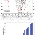
This study provides for the entire continent of Africa the position/ velocity solution precisely expressed with reference frame IGSR3
Saturday E Usifoh
GFZ German Research Centre for Geosciences, Potsdam, Germany Institut für Geodäsie und Geoinformationstechnik Technische Universität, Berlin, Germany Centre for Geodesy and Geodynamics, Toro, Bauchi State, Nigeria
Benjamin Männel
GFZ German Research Centre for Geosciences, Potsdam, Germany
Pierre Sakic
GFZ …

We give an example of a straight forward procedure tailored to understand and question the effects of different error components in both SIS domain and the position domain
Adrià Rovira-Garcia
Research group of Astronomy and Geomatics, Universitat Politècnica de Catalunya, Spain Corresponding author: Universitat Politecnica de Catalunya, Spain, adria.rovira@upc.edu
Deimos Ibáñez-Segura
Research group of Astronomy and Geomatics, Universitat Politècnica …
Omnispace and Ligado Networks announced a Memorandum of Understanding (MOU) to combine their respective licensed mobile satellite services (MSS) spectrum to enable the world’s most capable space-based, direct-to-device (D2D) solutions for global voice, text and data connectivity.
Utilizing large blocks of satellite spectrum in the L- and S-Bands, this agreement sets the stage for the development of multi-band, …

 |
Introduction To Geodesy... |
 |
This comprehensive book charts the course of NSDI journey in India, which is still continuing... |

 |
“A world of multi-GNSS brings faster and more innovations“
Sherman Lo |


 (5.00 out of 5) (5.00 out of 5) (5.00 out of 5) (5.00 out of 5)
