
Volume 22, Issue 2, February 2026 |
|
||||||||||||||||||||||||||||||||||
|
||||||||||||||||||||||||||||||||||
Volume 22, Issue 1, January 2026 |
|
|||||||||||||||||||||
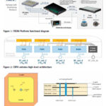
This paper presents the TRENI railway GNSS receiver and antenna development, to be used directly or integrated in a train multi-sensor safe positioning platform, suitable for railway safety-related applications
Marco Puccitelli
Thales Alenia Space Italia., Via E. Mattei 1, 20064 Gorgonzola (Milan), Italy
Chiara Manno
Thales Alenia Space Italia., Via E. Mattei 1, 20064 Gorgonzola (Milan), Italy
Livio Marradi
Thales Alenia …

This paper offers a state-of-the-art review of several proposed methods for interference detection and mitigation with solutions ranging from traditional to machine learning-based approaches.
Arul Elango
Department of Computer Science, University of Helsinki, Finland
Ahmed Al-Tahmeesschi
Department of Computer Science, University of Helsinki, Finland
Mikko Saukkoriipi
Department of Computer Science, University of Helsinki, Finland
Titti Malmivirta
Department of Computer Science, University of Helsinki, …

A clear, methodical and scientific distinction needs to be drawn between land use and land cover, especially in the context of urban planning and development
Dr Mahavir
Former Professor and Dean (Academic), School of Planning and Architecture, New Delhi, India
Dr Prabh Bedi
CEO, Resonance Integrated Solutions Canada Inc., Canada
The geospatial industry got another impetus from Government of India …
STMicroelectronics’ ST87M01 ultra-compact and low-power modules combine highly reliable and robust NB-IoT data communication with accurate and resilient GNSS geo-location capability for IoT devices and assets. The fully programmable, certified LTE Cat NB2 NB-IoT industrial modules cover worldwide cellular frequency bands and integrate advanced security features.
As one of the first IoT cellular products worldwide offered …
SIMCom has launched the optimized LTE Cat.1 bis module the SIM7672X Series, delivering an all-encompassing solution that offers a new generation of fast, powerful, high-performance IoT connectivity with global network coverage, lower costs,smaller form factor, and higher power efficiency.
The SIM7672X Series supports 3GPP R14 standards and there are three regional variants including North American( including the …

 |
Introduction To Geodesy... |
 |
This comprehensive book charts the course of NSDI journey in India, which is still continuing... |

 |
“A world of multi-GNSS brings faster and more innovations“
Sherman Lo |


 (5.00 out of 5) (5.00 out of 5) (5.00 out of 5) (5.00 out of 5)
