Volume 22, Issue 1, January 2026 |
|
||||||||||||||||||||||||||||||||||
|
||||||||||||||||||||||||||||||||||
Volume 21, Issue 12, December 2025 |
|
|||||||||||||||||||||
Taiwan, highly exposed to natural disasters, has transformed its disaster management through the Taiwan National Federated Research Data Repository. Powered by the datacube engine rasdaman, this platform integrates satellite imagery, UAV data, and IoT sensor streams across agencies, overcoming long-standing silos. By enabling real-time AI analytics, 3D flood simulations, and secure inter-agency data sharing, it enhances national …
The Lands Commission unveiled the Continuous Operating Reference System (CORS) Network to enhance data accuracy of fieldwork and survey operations across the country.
The global positioning system (GPS) CORS Network would provide 24/7 nationwide geospatial data access, ensure real-time centimetre-level accuracy for fieldwork and boost revenue stream for the Commission.
The GPS CORS Network is a collaboration …
The new USGS map, called The Cooperative National Geologic Map, was created using more than 100 preexisting geologic maps from various sources and is the first nationwide map to provide users with access to multiple layers of geologic data for one location. This feature allows users to access the multiple data sources included in the map …
The Royal Institution of Chartered Surveyors (RICS) has published the first global professional standard for the responsible use of artificial intelligence (AI) in surveying practice – a decisive move to guide the profession through the rapid evolution of AI technologies.
Set to take effect on 9 March 2026, the new standard sets out mandatory requirements and …

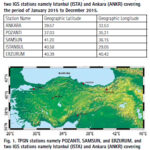
The study investigates ionospheric TEC variation over the Turkish region using 5 GNSS stations. The results showed that the overall TEC values display the trend of normal diurnal and annual TEC variations.
Kutubuddin Ansari
Faculty of Geodesy and Cartography, Warsaw University of Technology, Warsaw, Poland
Janusz Walo
Faculty of Geodesy and Cartography, Warsaw University of Technology, Warsaw, Poland
Selcuk Sagir
Department …


 (5.00 out of 5)


 (5.00 out of 5)


 (5.00 out of 5)


 (4.99 out of 5)