
Articles in the Articles Category


Continuously Operating Reference Stations (CORS) networks have been utilized for the last two decades in most developed and some developing countries by surveyors, geomatics and earth scientists and engineers. They handle Global Navigation Satellite System (GNSS) data which support three dimensional positioning not only

For space faring nations or group of nations, maintaining their autonomy in the engineering of technologies allowing the success of exploration missions is mandatory. This article focuses on one of these technologies…

The solar activity generates Electromagnetic radiations and Energetic Charged Particles in addition to the Galactic Cosmic Radiation that directly impact the earth magnetosphere and then the ionosphere.
February 2014
International LiDAR Mapping Forum
17 – 19 February 2014
Denver, Colorado, USA
www.lidarmap.org/international
March 2014
Munich Satellite Navigation Summit 2014
25 – 27 March
Munich, Germany
www.munich-satellitenavigation-summit.org
ASPRS 2014 Annual Conference
23 – 28 March 2014
Louisville, Kentucky USA
April 2014
ENC-GNSS 2014
14 – 17 April
Rotterdam, The Netherlands
www.enc-gnss2014.com
SPAR International
14-17 April 2014
Colorado Springs, CO, USA
http://www.sparpointgroup.com/international/
Interexpo GEO-Siberia 2014
16 – 18 April
Novosibirsk, Russia
http://expo-geo.ru/event/27
…

The U.S. Department of Transportation’s Federal Aviation Administration (FAA) released on November 7, 2013 its first annual Roadmap outlining efforts needed to safely integrate unmanned aircraft systems (UAS) into the nation’s airspace. The Roadmap addresses current and future policies

Bhuvan (www.bhuvan.nrsc.gov.in), a unique geoportal of NRSC that provide diversified geospatial services, is gaining popularity day by day and is much appreciated for its dynamic services. Initiated in 2009, Bhuvan has grown up rapidly and has made its impact on Indian user community. Expanding it’s state-ofart facilities and a datacentre at Hyderabad, Bhuvan is now extending geographically with its distributed architecture.
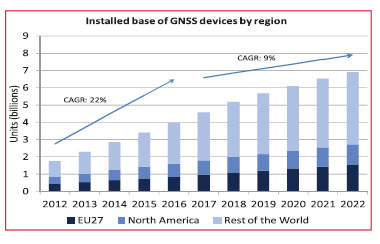
On the 15th of October 2013 the European GNSS Agency (GSA) released the latest version of its GNSS Market Report. The Market Report brings an updated and enhanced view of the GNSS global market “as it is experimenting rapid developments”. It encompasses a larger scope than before

China has invested enormous effort in manned space engineering. The Tiangong-1 and Shenzhou-8 have been launched, twice rendezvouses have been accomplished successfully. In order to meet the requirements of the manned space engineering on the TT&C network, and prepare for our country’s space station construction

Potential conflicts between customary and / or informal systems of land tenure with the state supported formal systems of land registration are an issue in many developing regions. Africa presents a significant challenge because the traditional authorities (chiefs, clans, families etc.)

“We were impressed with thesoftware’s capability and processingtimes. The results achieved were notonly produced quickly, but with a highdegree of accuracy”- Mr. Mohamad El Kadi, Managing Director of Space Imaging Middle East


 (5.00 out of 5)