Articles in the Articles Category


What is your vision with regard to Trimble expansion plan in India?
Our vision is to determine the challenges that our Indian customers are trying to solve in the Utilities, Construction, Infrastructure, Mobile Resource Management, GIS and Mapping, Public Safety and Surveying industries to develop localized software and hardware solutions that meet their needs for increased productivity and reduced rework. We offer solutions that have been proven worldwide and now we must determine if these solutions meet the needs of the Indian customer. Where the solutions do not meet their needs or requirements we must adapt them so they can provide our customers maximum productivity advantages. We can accomplish this by adding resources in our Delhi and Chennai offices in marketing, R&D and sales. Where we find it necessary to create or integrate new solutions to address the unique needs of the Indian market,

It had a gloomy start. With uncertainties and apprehensions. Disappointments and cynicism.Many whom we banked on went bankrupt.It was also the time.To change thinking, strategies and approach.

Ownership and long term leasehold are the most important rights in land. The actual content of these rights may vary between countries and jurisdictions, but in general the content is well understood. Rights to land also include the rights of use. This right may be limited through public land use regulations and restrictions, sectoral land use provisions, and also various kind of private land use regulations such as easements, covenants, etc…
January 2010
Asia Oceania Region Workshop on GNSS
25-26 January 2010
Bangkok, Thailand
www.multignss.asia/workshop.html
March 2010
Munish Satelite Navigation Summit
9-11 March
Munish, Germany
www.munish-satelite-navigation-summit.org
GEOFORM+’2010
30 March -2 April
Moscow, Russia
www.geoexpo.ru
Digital Preservation of Archaeological Heritage
10-12 March, 2010.
IIT Kanpur, Kanpur, India
arch3d@iitk.ac.in
www.iitk.ac.in/arch3d
CARIS 2010
22-25 March
Miami, Florida, USA
www.caris.com/caris2010
April 2010
XXIV FIG International Congress 2010
11 …
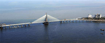
Introduction The Bandra-Worli Sea Link (BWSL) is a civil engineering marvel spanning an arc of the Mumbai coastline. With its cable-stayed towers soaring gracefully skywards, the sea link is a reflection of the modern infrastructure that Mumbai is adding in its progress towards becoming a world-class city…

Many of the world’s volcanoes that erupt, experience significant preeruption surface deformation. Internal magma pressure makes the surface bulge upwards and outwards. Thus, precise monitoring of surface deformation has the potential to contribute significantly to the realisation of a predictive capability of volcanic eruption. In particular, eruption source depth and evolution time can be estimated from surface deformation…

ll countries have to deal with the management of land. They have to deal with the four functions of land tenure, land value, land use, and land development in some way or another.
National capacity may be advanced and combine the activities in one conceptual framework supported by sophisticated ICT models. More likely, capacity will involve very fragmented and basically analogue approaches…

Landslide is a common hazard in the hilly regions which causes heavy losses to life and properties every year. Since 1980 various researches and analyses have been carried out in the GIS environment to identify factors responsible for causing landslides. The important conditioning factors identified by the researchers are slope, geological, geomorphologic structures and land use coupled with triggering factors like rainfall and a few of the anthropogenic activities…
November 2009
INCA 2009
25-27 November
Kolkata, India
http://www.incaindia.org
ISPRS (Geospatial Data Cyber Infrastructure)
25-27 November
Hyderabad, India
http://www.incois.gov.in/isprs
Delays, litigations, cost overruns.
Technical and engineering challenges.
Social and environmental concerns.
And more importantly, non-willingness at many levels.
All the ingredients of a mega infrastructure project in India.
Yet, the Bandra-Worli Sea Link has happened


 (5.00 out of 5)