Articles in the Articles Category

April 2006
Geo-Siberia 2006
26-28 April in Novosibirsk, Russia
http://www.sibfair.ru/en/exhibition.php?id=533
May 2006
European …
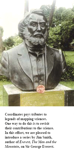
Beginning with this issue, JR Smith traces the life and work of Sir George Everest
My interest in Everest came about in two ways. Firstly in the early 1980s I had the idea of compiling a history of land surveying. It was soon obvious that it was a far too wide a topic to do justice …

says Dr Vanessa Lawrence, Director General and Chief …

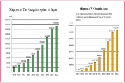
The GPS technology is being used extensively all over the world to generate useful data for different purposes. The Department of Science
and Technology, Government of India has evolved a programme on GPS to study crustal deformation processes with the following objectives…
GAGAN is an Indian Space Based Augmentation System (SBAS). Airports Authority of India (AAI) and Indian Space Research Organization (ISRO) to provide the seamless navigation service for all the phases of fl ight over Indian airspace jointly undertake this project. The AAI’s efforts towards implementation of operational SBAS can be viewed as the first step towards introduction of modern CNS/ATM system over Indian airspace…
Own, control, use and misuse.
That’s the story about information.
When search engines like Google, Yahoo and Micorsoft open new vistas …
April 2006
National Workshop on Role of Geodesy in Surveying Practices
10 – 11 April, 2006, Geodetic & Research
Branch, Survey of India, Dehradun
gandrb@vsnl.net
IEEE/ION PLANS 2006
25- 27 April, San Diego, …
says Dr Hiroshi Nishiguchi, Secretary General, Japan …

JAESat is an Australian joint micro-satellite project between Queensland University of Technology, Australian Space Research Institute and other national and international partners, i.e. Australian Cooperative Research Centre for Satellite Systems, Kayser-Threde GmbH, Aerospace Concepts, Auspace to name some of them


 (5.00 out of 5)