Articles in the Articles Category

July 2026
XXV ISPRS Congress
4 – 11 July 2026
Toronto, Canada
www.isprs2026toronto.com/
Esri User Conference 2026
13 – 17, July
San Diego USA
www.esri.com
August 2026
13th IGRSM Conference 2026
05 – 06 August
Kuala Lumpur, Malaysia
https://conferences.igrsm.org/
September 2026
Esri India User Conference
2 – 3 September 2026
…
The images from the Venezuela earthquake are heartbreaking.
Collapsed homes, frantic searches through rubble, grieving families, and lives transformed in moments.
Every calamity reminds us how fragile human existence truly is.
Nature neither negotiates nor discriminates.
Its forces remain beyond human control.
Each time the Earth trembles,
We watch helplessly as lives are upended and …

The analysis performed in this report is solely the author’s work and his opinion.
Narayan Dhital
Actively involved to support international collaboration in GNSS related activities. He has regularly supported and contributed to different workshops of the International Committee on GNSS (ICG), and the United Nations Office for Outer Space Affairs (UNOOSA). As a professional employee, the …

The findings of this research will provide valuable recommendations for the FCTA to implement a people- friendly land administration policy.
Okpeke, Philip Ochene
Corresponding Author, University of America, California, USA
Aransiola, Yusuf Abdullatif
University of America, California, USA
Professor Prince Michael Ikupolati
Corresponding Author, University of America, California, USA
Abstract
This study explores the critical role of development communication in promoting sustainable land …
An expanding Ebola outbreak in parts of Africa,
And recent hantavirus cases linked to global travel,
Underline how rapidly health risks can cross borders.
Different viruses, different transmission patterns, but a common warning.
Public health systems remain reactive while outbreaks grow increasingly interconnected.
Ebola continues to test surveillance and fragile healthcare systems.
The hantavirus incident, …
June 2026
ICCGIS 2026
14 – 19 June 2026
Nessebar, Bulgaria
https://iccgis.cartography-gis.com/
4th Geospatial & Space Technology MENA Forum
24 – 25 June 2026
Dubai, United Arab Emirates
https://menageospatialforum.com/
July 2026
XXV ISPRS Congress
4 – 11 July 2026
…
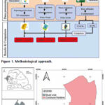
The result from the GNSS processing method achieved the best performance in terms of absolute error evaluation
Mouhamadou Moustapha Mbacké Ndour
UFR-SI, University of Iba Der Thiam, Thiès, Senegal
Papa Matar Sylla
Holding Gueye, Dakar, Senegal
Alphousseyni Ndonky
UFR-SI, University of Iba Der Thiam, Thiès, Senegal
Babacar Faye
Simon & Christiansen Afrique (S.C.A), Dakar, Senegal
Abstract
The spatial representation of the Earth’s surface, as well …

The analysis performed in this report is solely the author’s work and his opinion.
Narayan Dhital
Actively involved to support international collaboration in GNSS related activities. He has regularly supported and contributed to different workshops of the International Committee on GNSS (ICG), and the United Nations Office for Outer Space Affairs (UNOOSA). As a professional employee, the …

As we architect the next generation of Research Projects and National Health Data Stacks, our conclusion must be rooted in a “Phy-gital” reality where technology does not replace the Physician or experience, but empowers them with planetary-scale health insight intelligence.
Dr. Mukund Kadursrinivas Rao
Is an internationally recognized leader in space and geospatial technologies, with deep multidisciplinary …

A courtroom in the United States,
Is now confronting a long-standing question.
Did social media merely host behaviour or actively shape it?
As Mark Zuckerberg defends Meta,
The issue extends beyond one company.
It is about the architecture of attention.
Past goals to maximise user engagement now face legal scrutiny.
Design choices that may amplify …


 (5.00 out of 5)