Articles in the Articles Category

April 2010
Geo-siberia 2010
27 – 29 April
Novosibirsk, Russia
www.geosiberia.sibfair.ru
ASPRS 2010
26-30 April
San Diego, CA, USA
http:/www.asprs.org/Sandiego2010
May 2010
INTERGEO East
19-21 May 2010
Istanbul, Turkey
www.intergeo-east.com
TIDES 2010
20 – 21 May
Taipei, Taiwan, R.O.C.
derc@mail.pccu.edu.tw
International Conference on Integrated Navigation Systems
31 May – 02 June 2010
Saint Petersburg, Russia
http:/www.elektropribor.spb.ru
June 2010
Toulouse Space Show 2010
8 -11 June
Toulouse, France
Contact@toulousespaceshow.eu
www.toulousespaceshow.eu
IMTA Asia Pacific Conf. & Trade Show
18 -19 June
Melbourne, Australia
www.maptrade.org/events
GEA’2010
22 -24th June
Cracow, Poland
jacek@gea.com.pl
http://gea.com.pl/targieng.php
July 2010
ISPRS …

Do you know…
That I know…
The process.
To determine positions.
Accurate positions.
Of ‘what’ and ‘where’.
On and around this Earth.
I prepare the foundation.
The basics of ‘knowledge’.
On which much can be built.
I play a role.
A very important role.
Who am I?
I know that you know.
Still, I reiterate.
That I am a surveyor.
Bal Krishna, Editor
bal@mycoordinates.org
Tweet

Over the past 100 years the world’s total population has quadrupled – from 1.6 billion to 6.6 billion. (Footnote: Population Bulletin, “World Population Highlights: Key Findings From PRB’s 2007 World Population Data Sheet” http:// www.prb.org/Articles/2007/623WorldPop. aspx.) In many parts of the world we see growing poverty. We now face increasingly worrisome resource constraints and environmental difficulties,

A GAGAN (GPS Aided Geo Augmented Navigation) is an Indian SBAS (Satellite Based Augmentation System) intended to provide accurate and reliable navigation information for all phases of flight over the Indian FIR (Flight Information Region) and in the adjoining areas applicable for safety-of-life operations meeting the performance requirements of ICAO. The implementation of the GAGAN program is being realized through the following two phases…

There are some countries trying to develop their own GNSS system. Is there any race? If yes, how appropriate and where would it lead to? Here are some views
“Well first of all there is the issue of robustness and putting all your eggs in one basket – that is one aspect and a major legitimate concern. The other, is a matter of national pride. In Europe there is a feeling that GPS dominates things…

It is not a GNSS race.
It is about space.
Capturing the space.
It is not about the ‘rules’ of the race.
It is about ‘who will rule’.
It is not about ‘roles’.
It is about ‘controls’.
It is not about wrongs and ‘rights’.
It is about ‘the rights’.
.. It is about might, only, the might.
Bal Krishna, Editor
bal@mycoordinates.org
Tweet
April 2010
XXIV FIG International Congress 2010
11-16 April 2010
Sydney, Australia
www.fig2010.com
Geo-Serbia 2010
27-29 April
Novosibirsk
www.geosiberia.sibfair.ru
ASPRS 2010
26-30 April
San Diego,CA,USA
www.asprs.com/San Diego2010
May 2010
TIDES 2010
20 – 21 May
Taipei, Taiwan, R.O.C.
derc@mail.pccu.edu.tw
International Conference on Integrated Navigation Systems
31 May – 02 June 2010
Saint Petersburg, Russia
http:/www.elektropribor.spb.ru
June 2010
Toulouse Space Show 2010
8 -11 June
Toulouse, France
Contact@toulousespaceshow.eu
www.toulousespaceshow.eu
IMTA Asia Pacific Conf. & Trade Show
18 -19 June
Melbourne, Australia
www.maptrade.org/events
GEA’2010
22 -24th June
Cracow, Poland
jacek@gea.com.pl
http://gea.com.pl/targieng.php
July 2010
ISPRS Centenary …

Donald G DeGryse
says Donald G DeGryse, Vice President, Navigation Systems for Space Systems Company, Lockheed Martin
The Navigation Systems business unit was established in 2001 and has had an eventful journey so far. What in your opinion are three ‘landmarks’ achieved by the unit since 2001?
Navigation Systems was established to combine Lockheed Martin’s world-class system engineering …
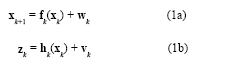
The Global Positioning System(GPS) (Brown and Hwang 1997; Farrell and Barth 1999; Gelb 1974) and inertial navigation system (INS) have complementary operational characteristics and the synergy of both systems has been widely explored. An integrated GPS/INS system is typically carried out through the extended Kalman filter (EKF). The EKF is the approximate nonlinear filters which linearizes the system…

Earthquakes, landslides, avalanches, collapsed buildings… There are many situations in which people could suddenly become trapped and unable to free themselves without the assistance of search and rescue professionals…


 (5.00 out of 5)