| Her Coordinates | |
Making Sense in the Sky
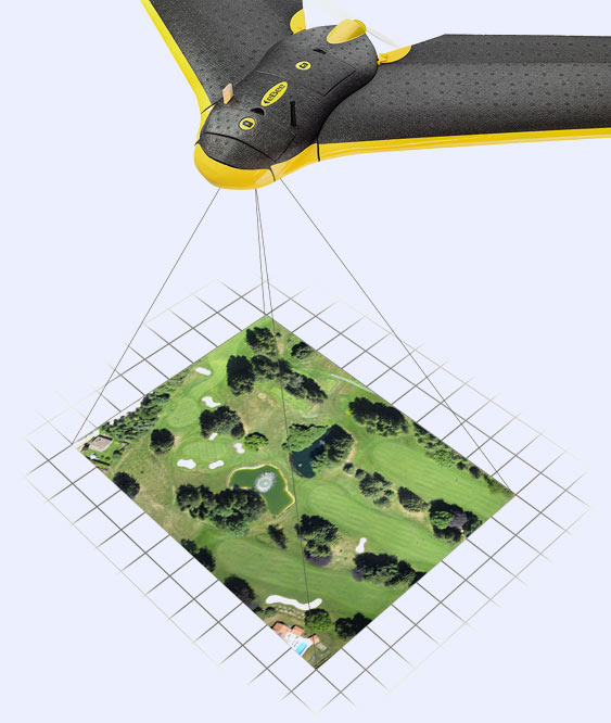
What are the key features of senseFly drones?senseFly drones were developed to offer end users a comprehensive mapping system that is both easy to use and portable without the need to be an experienced pilot. With our systems being the lightest in the industry at less than 700 grams and compact enough to fit into a single hand luggage case transportation is not a problem even to remote launch sites. Our hand launched systems are fully automated from mission planning to flight and landing making them simple to use, while also off ering live monitoring via a tablet or laptop where users can track the entire mission and make adjustments to the flight plan, when and if required. How different is the eBee from the Swinglet CAM?The eBee is not only an improvement on the swinglet CAM but a whole new system. Designed as a modulated system with removable wings the eBee’s camera and sensors are all fully enclosed within the body of the unit. The eBee can fly in much stronger winds then it predecessor (45km/h compared to 25km/h). Another advantage of the eBee is it utilizes reverse thrust technology, which enables the drone to slow down on descent enabling it to land in a softer, more controlled manner in either linear or circular modes. It also boasts a new ground proximity sensor, which senses the ground on landing for increased accuracy as well as in-flight safety to avoid collision with the ground.
At what altitudes can the Swinglet CAM and the eBee operate?Although senseFly drones can easily operate up to 1000m above ground, most projects are completed between 90 & 150m, due to both resolution accuracies and flight regulations. Being constantly in search of a new challenge our team has tested absolute altitude at up to 3000m in the Swiss Alps. In case of high wind speed or drop in battery charge, how will the users manage to operate it back to safety?A lot of emphasis has been placed on safety within senseFly and our systems have been designed with this in mind. We want to make sure our end users feel comfortable and safe using our products and as a result we have automated to a large degree our fail safe procedures. When wind conditions become too strong, low GPS or low battery is experienced for example, the user will automatically be notified and the unit will return home without any user input being required. Other safety protocols such as a buff er zone and loss of radio link add additional protection as well. Can both the drones be repaired in case of damage?At senseFly we realize the importance of keeping the client working whenever possible and so our technical service team are on hand to assist end users in completing minor repairs in the field where possible. In association with our ever expanding distributor network we have developed fully authorized service centers in a number of countries which have the ability to carry out required service repairs in addition to our own repair center in Lausanne, Switzerland. The eBee system has been designed for longevity, as we understand the importance of return on investment for the end user. To achieve this the eBee has been designed for optimum protection of its critical parts, in addition to this minor repairs and replacement of the most exposed parts such as the wings and underbody are easy to carry out. Could you describe the role of eMotion2 and Postflight Terra software?eMotion 2 is our quick to learn and easy to use, intuitive ground station software allowing you to plan, simulate, monitor and control the trajectory of the eBee both before and during flight. Postflight Terra 3D-EB is a professional photogrammetry software that runs on your desktop computer or laptop and processes aerial imagery into 2D maps and 3D models with centimeter accuracy with just a couple of clicks. What kind of authorization is required for using the drones? Are there special permission required in certain countries?Authorization requirements are dependent on the country of use with most countries now adopting some form of UAV or UAS specific regulations. Some countries for example required operators to complete an authorized training course, which our distributors advise and guide our customers through. In others, for example, Switzerland, the only regulation is to keep it in the line of sight while flying. At senseFly, we believe it would make sense to differentiate the regulations depending on the weight and structure of drones. Drones, which are very light and small, like ours, do not present the same danger as larger, heavier systems do. You have supported several humanitarian projects with your excellent technology. Could you please mention some of them for benefit our readers.We recently supported Drone Adventures (Drone Adventures is a young nonprofit organization based in Lausanne, Switzerland. Their goal is to promote the great potential of drones in civilian applications, focusing on conservation, humanitarian, cultural and search and rescue domains.) who completed a mission in Haiti in collaboration with the International Organization for Migration (IOM) and the Humanitarian Open Street Map Team (HOT). They used three eBee drones to map ten different sites for a total coverage of approximately 45km2, all done in just 1 week. The resulting data allowed 3D terrain models to be created, which enabled them to perform waterflow simulations. This will be used in the planning of infrastructures whilst mitigating against flooding and to protect dense urban encampments near dangerous riverbeds. Several shantytowns were also mapped allowing them to count the tent locations and to help organize the population census as well as distribute aid. On top of this, 2D and 3D maps of the University of Limonade situated in the north of the country were also accomplished. These maps will help to promote this brand new university, which should play a significant role in the economic and social development of the country.
|


 (21 votes, average: 1.86 out of 5)


Leave your response!