Articles in the Articles Category


Urban Population in India increased from 62 million (19%) in 1951 to 377 million (31%) in 2011, and is expected to increase up to around 37% by 2021.

The problems in sharing of geospatial data among public sector organizations is a well established fact (Onsrud et. al., 1995; McLaughlin, 2003; Williamson et. al., 2004; Nebert, 2004; Masser, 2005; Georgiadou, 2006; Nama Raj Budhathoki and Zorica Nedovic-Budic

Satellite navigation relies on the visibility of a sufficient number of satellites. As the number of satellites increases, some problems such as shadowing in urban areas are reduced although not completely removed. In other instances, such as in tunnels, positioning by satellites is not possible.

From 1992 to 2011, air traffic grew by approximately 72% in Germany [1] which is equivalent to a yearly increase of about 4%. As air traffic continuously increases, ground infrastructure like airports, number of runways and necessary capacity of air traffic routes need to grow too.
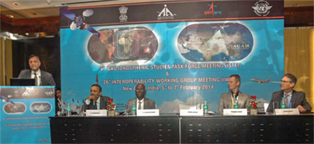
After the recent landmark achievement of certification of Indian SBAS System GAGAN for RNP 0.1 operations, India is hosting two back to back high-level technical meetings i.e. 4th Ionospheric Study Task Force (ISTF/4) under the aegis of ICAO and the 26th Interoperability Working group in New Delhi , providing further impetus to harmonized development of Satellite Based Navigation systems across the world.
March 2014
Munich Satellite Navigation Summit 2014
25 – 27 March
Munich, Germany
www.munich-satellitenavigation-summit.org
ASPRS 2014 Annual Conference
23 – 28 March 2014
Louisville, Kentucky USA
April 2014
ENC-GNSS 2014
14 – 17 April
Rotterdam, The Netherlands
www.enc-gnss2014.com
SPAR International
14-17 April 2014
Colorado Springs, CO, USA
http://www.sparpointgroup.com/international/
Interexpo GEO-Siberia 2014
16 – 18 April
Novosibirsk, Russia
http://expo-geo.ru/event/27
Interexpo-GEO-Siberia-2013
IGRSM 2014
21 – 22 April
Kuala Lumpur, Malaysia
http://www.igrsm.com/igrsm2014/
2014 International Satellite Navigation Forum
23 – 24 April
Moscow, Russia
http://eng.glonass-forum.ru
9th National GIS Symposium …
The European Commission, Directorate- General Environment, is inviting comments on the implementation of the Infrastructure for Spatial Information in the European Community (INSPIRE) Directive (2007/2/EC).

GAGAN certification
Satellite Based Augmentation System gets another boost,
As India joins USA, Japan and Europe to implement the operational SBAS.
GAGAN (GPS Aided GEO Augmented Navigation) achieves
RNP 0.1 certifi cation on December 30, 2013.
Type 2 message will be available in February 2014.
This enables Indian Flight Information Region (FIR) to support satellite based
augmentation services for precision navigation by …

Urban areas garbage is collected either by a government agency or private contractor. Garbage disposal constitutes a basic and expected service or function of urban local body.

Spatio-temporal rainfall changes at tropics had raised concern among scientists. However, comprehensive studies at catchment scale of Southeast Asia where the combined regional and local factor is a tough task to be carried out due to the inherent limitations of rainfall data sources especially in the remote


 (5.00 out of 5)