| GNSS | |
SBASs: Striving towards seamless satellite navigation
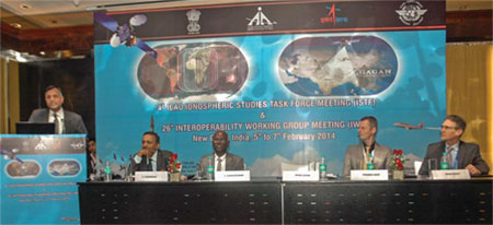
At the International Civil Aviation Organization (ICAO) 4th Ionospheric Study Task Force (ISTF/4) and 26th Interoperability Working group held at New Delhi from 5-7 February 2014, Coordinates interacted with experts on issues and challenges pertaing to different Space Based Augmentation Systems (SBASs) |
After the recent landmark achievement of certification of Indian SBAS System GAGAN for RNP 0.1 operations, India is hosting two back to back high-level technical meetings i.e. 4th Ionospheric Study Task Force (ISTF/4) under the aegis of ICAO and the 26th Interoperability Working group in New Delhi , providing further impetus to harmonized development of Satellite Based Navigation systems across the world.
ICAO ISTF has been tasked with the objective of collecting data, studying and developing Region-specific ionospheric models for implementation of Satellite Based Augmented Systems in Asia Pacific Region. As Asia Pacific Region comprises states that lie in equatorial ionospheric region and are affected by ionospheric scintillations which may result in loss of GNSS signal, developing an appropriate algorithm to mitigate them has become necessary.
The inter-operability Working Group is the forum for SBAS Service Providers, set up with the objective of harmonizing the global SBAS systems and ensuring seamless navigation with inter-operable systems.
Mr V Somasundaram, Board Member of AAI for Air Navigation Services, welcoming the delegates of both the meetings, emphasized the need for a collaborative approach among all the States, ANSPs and SBAS providers for finding a common solution to mitigate the Ionosheric Effects and work towards Harmonizing SBAS Standards and Systems leading to Global Harmonization.
Mr Frederick Lecat ,Regional Officer, ICAO and Mr Dean Bunce, FAA, WAAS Program manager, delivered their technical address. The officials thanked India for supporting the ICAO initiatives on SBAS and congratulated India on becoming the 4th certified SBAS developer in the world.
Mr A S Ganeshan, Outstanding Scientist, ISRO elaborated on GAGAN development leading to the certification for RNP 0.1 operations and the upcoming IRNSS which is set to become operational by 2015. IRNSS is an Independent Regional Navigation Satellite System being developed by India indigenously and in conjunction with GAGAN would provide accurate position information service to users in India.
Mr Ashok Lavasa, Secretary Civil Aviation , delivering the keynote address, appreciated the Indian ANS initiatives leading to safety and efficiency of aircraft operations and remarked that the huge 12th Five Year outlay for Aviation Industry would foster the Aviation Growth in the country. The Secretary also sought the attention of the participating States to the need for close collaboration among the States in finding solution to the complex Ionospheric issues and called for taking up all the required steps in ensuring interoperability of various SBAS systems across the world for seamless navigation.
India’s much-needed initiative in hosting both the meetings at the same venue brings together the prospective SBAS providers and the Asia Pacific States of on a single platform to support, research and develop reliable and interoperable SBAS systems leading to seamless satellite navigation regardless of boundaries.
GAGAN certified for aviation use by DGCA
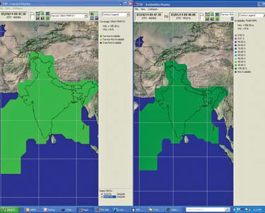
On 14th February 2014, GAGAN signalin- space was made available for providing Operational service to en-route flights within the entire Indian Flight Information Region covering both Bay of Bengal and Arabian Sea Regions.
This will now enable appropriately certified aircraft to derive the benefits of GAGAN. It will also enable AAI to develop and flight validate appropriate procedures using certified SBAS receivers. AAI will develop procedures to use GNSS for approach and landing in the coming months.
The GAGAN is designed to provide the additional accuracy, availability, and integrity necessary to enable users to rely on GPS for all phases of flight, from en route through approach for all qualified airports within the GAGAN service volume. GAGAN will also provide the capability for increased accuracy in position reporting, allowing for more uniform and highquality Air Traffic Management (ATM).
“GAGAN is available for aviation use from 14th February 2014”
 |
|
GAGAN achieves RNP 0.1 certification. Can you explain the significance?
RNP 0.1 service capability provides horizontal accuracy (95% containment) within ± 185 meters of the intended route of operation. RNP 0.1 is capable of supporting:
a) Reduced lateral and longitudinal separation minima and enhanced operational efficiency in oceanic (Bay of Bengal – Arabian sea- Indian Ocean within Indian Flight Information Region) and remote areas where the availability of navigation aids is limited.
b) Flexible ATS routes and airspace structure. Normally associated with continental airspace but may be used as part of some terminal procedures.
c) Arrival, Initial/Intermediate Approach and Departure; also envisaged as supporting the most efficient ATS route operations.
Based on the performance based navigation road map, India has published standard instrument departures (SID), standard arrival routes (STAR) for all major airports, LNAV (2D) / Baro VNAV approaches at Cochin and are in the process of publishing RNAV GNSS approaches at major airports.
All the above processes can be efficiently done by use of SBAS equipped aircraft without the need for additional RAIM (Receiver Autonomous Integrity Monitoring essential for GPS).
How GAGAN can benefit?
GAGAN has provided the capability for continuous real time monitoring and recording of GPS/ GAGAN data and is able to provide the users the advance predictability required for flight planning purposes.
GAGAN is already being utilized for non-aviation users such as:
a. Estimating Indian plate movements velocity
b. GCPL Network ( Ground Control Point Network )
c. Station Coordinate estimation, Update GCPL network
d. Demonstrated rapid GCP collection using GAGAN SBAS signal with an accuracy of better than 1m with observation time of 10min
e. Densification of GCPs through GCPL Ph3 project for future high resolution Cartographic mission
f. Integrating GAGAN SBAS data with GIS for navigational applications
g. Atmospheric studies –Tropo using GAGAN reference station data
h. Studies on scintillation in L-Band during equinox over India
i. Regular Station Coordinates estimation
j. Performance monitoring of GAGAN system
k. SBAS-SIS messages monitoring, comparison with other systems
GAGAN is available for aviation use from 14th February 2014. Initially performance monitoring and predictability tool is provided and the new procedures will be developed and published.
Which are the user segments other than aviation likely to be benefitted by the GAGAN?
Different user segment likely to be benefited by the GAGAN are as follows:
a. Road transport: – a wide range of applications including navigation devices to automatic toll systems, safety applications and pay-per-use insurance.
b. Air transport: – improved accuracy and integrity of navigation systems to optimize flight planning and so lower fuel use, time and emissions.
c. Maritime: – Vessel tracking and tracing inland water transport. Port approaches.
d. Rail transport: – signaling and train location systems. Improved safety of speed control and operating systems.
e. Agriculture: – Optimize crop control, reduce fertilizer and pesticide inputs, and ensure effective use of land and water.
f. Search and rescue: – allowing near real-time reception of distress messages from anywhere on Earth with precise location information between rescue centres and people in distress.
g. Location-based services: – Customers will be able to access specific ‘vicinity’ information through their mobile phone (e.g. the nearest restaurant or cash point machine, the best way to the nearest hospital).
h. Oil and gas: – Exploration and exploitation of oil and gas fields.
Being the first SBAS in equatorial ionospheric region, do you see some operational challenges?
Being the first SBAS in the equatorial ionospheric region, there have been many operational challenges. The need for rewriting the algorithm meeting the EIA region required research work from the Indian Scientific community spear headed by ISRO. India had installed a total of 26 Total electron Content stations for collection of Iono data from all over India since 2004. The data analysis was further augmented from the inputs of eight GAGAN reference stations installed in 2007 under the technology demonstration phase. The algorithm working group formed by ISRO continued its work in coordination with many Indian Universities over the last five years to provide the new algorithm that would work for GAGAN. The results was reviewed by a Technical review Team formed by DGCA to look into certification. The algorithm is undergoing the process of fine tuning. GAGAN is expected to be ready for Approaches with vertical guidance (APV1) by the end of 2014
How important is the issue of interoperability in the context of SBAS?
Only those receivers that can process SBAS messages can be used for receiving GAGAN messages. But all those receivers that can receive WAAS/EGNOS or MSAS can receive GAGAN and GAGAN is interoperable with other SBAS receivers.
Taking Stock of EGNOS
Coordinates spoke with Jean-Marc Pieplu,Head of the EGNOS Exploitation Program andCarmen Aguilera, Market Development Offi cerat the European GNSS Agency, and DidierFlament, Head of EGNOS and SBAS Division atthe European Space Agency about the service,its current success and plans for the future.
 |
|
 |
|
 |
|
What is the status of EGNOS?
Everyday EGNOS delivers the services it has been designed for, with a remarkable level of stability and performance. The Open Service improves the accuracy of GPS horizontally and vertically to meter-level and the Safety-Of-Life service delivers continuous integrity protection in compliance with ICAO Standards, allowing APV-I approaches with an over 99% availability. The EDAS Service provides EGNOS data to professional users for added-value applications and scientific use.
EGNOS Operations continue to manage technological transitions as needed to renew any obsolete infrastructure. For example, migration to a modernized ground communications network technology was successfully deployed in January 2014, migration to the two new geostationary dual-frequency transponders on-board SES-ASTRA satellites is underway (new L1 signals foreseen in 2014 and 2015), and renewal of obsolete ground stations and processing centres is under preparation.
Continued EGNOS operations and service provision has been ensured through a new contract awarded by the GSA to the ESSP last year. This contract is now implemented in the framework of the new GNSS Regulation 1295/2013 adopted by the European Union in 2013. This ensures the multi-year financing of the EGNOS program until 2020, and establishes a new governance structure where the GSA responsible for EGNOS Exploitation under delegation by the European Commission. This includes the development of future system evolution to be implemented through an arrangement with ESA.
In the past, the Service improvements focussed on APV-1 availability and coverage provided thanks to changes implemented in the Ionospheric Processing and the addition of some stations. The APV-1 service, as offered by the release V2.3.2, is now much more robust to ionospheric perturbations than when EGNOS was declared operational. The next improvement will be the delivery of the LPV200 service which is under study and for which a preliminary service area should come with the V241M / V241P. After this, the next major system evolution (v2.4.2) should be operational by 2017 aiming at solving the remaining obsolescence issues. Finally the second generation of EGNOS, ‘EGNOS Dual Frequency Multi-Constellation’ (or EGNOS V3) is under study by ESA in their EGEP Program. EGNOS V3 is planned to offer significantly improved service performance (accuracy, continuity of service, lower vertical alert limit, coverage) thanks to new signals and Galileo satellites. These services are prepared for the second generation EGNOS/GPS/Galileo User Receivers (avionics) planned to equip aircraft before 2025.
Which areas does EGNOS benefit?
EGNOS aims to cover the territories of the 28 EU Member States. Today, EGNOS has almost reached this goal, with several border areas still to be covered. The extension to full EU-28 coverage is a main program objective and a priority for the next system evolution. The system is facing obsolescence of some ground monitoring stations which is limiting the capacity to deploy new monitoring sites in the short term. New developments should be launched to ensure the technology refresh required to deploy and maintain further coverage extension capacities.
What are your plans to ensure interoperability?
The compatibility and interoperability between SBAS, and with neighbouring systems, is necessary to ensure proper service delivery to end users and to enjoy maximum benefits from SBAS technology. It impacts the design of system evolution towards multi-frequency and multiconstellation service provision, but also dayto- day operations. For example, EGNOS is currently addressing with our Russian partners the compatibility between the EGNOS signals transmitted by Inmarsat 3F2 and the new signals transmitted by Luch 5B. SBAS are delivering regional signals and services over coverage areas which are mutually complementary or overlapping. Cooperation between SBAS service providers is thus a key enabler for all SBAS and a clear program objective for EGNOS since it is in the best interest of users.
There are several international technical working groups used to sustain the current and future interoperability between SBAS. These include the sub-groups of the Standardisation bodies (ICAO, RTCA, Eurocae) as well as the Interoperability Working Group IWG. The IWG was created by US FAA and European ESA in early 2000’s and is meeting twice a year. One of the important tasks of this group is the development of the Dual Frequency Multi-Constellation Definition document and associated Interface Control Document. This ICD is the first important step towards the second generation SBAS Standard that will continue to guarantee full interoperability between all SBAS.
What is the progress in developing user standards?
Europe is active in the development of future SBAS standards, which are a cornerstone for the new generation of EGNOS. Two main lines of activities are under way: the development of standards for Galileo signals use and the development of DFMC (Dual-Frequency Multi-Constellation) SBAS standards. Concerning the new SBAS standards, a stable definition of the new L5 messages is expected to be established with our SBAS partners in 2014 in order to be proposed to avionics manufacturers within the year and launch the preparation of associated MOPS for Aviation. A similar effort supporting the Maritime user community has been initiated and will continue.
Any plans to develop multifrequency capacity?
We intend to develop this capacity for EGNOS, which is expected to bring additional service robustness against ionospheric perturbation and ease the service coverage extension with a minimum number of ground monitoring stations. SBAS will then become even more reliable. The mission requirements are currently under consolidation and should be stabilized before year end. We will then benefit from the EGEP Program financed by ESA Member States, the results of which will be re-used in the Exploitation phase. The EGNOS space segment compatible with this multi-frequency capacity will be fully deployed in 2014 with three transponders on-board Inmarsat and SES-ASTRA satellites. The Service Provision capacity, for which development still depends on the joint definition of a new L5 ICD, will require a multi-year ground segment and operations transition that is currently envisaged to be completed between 2021 and 2023.
Two contracts are on-going within ESA for the definition of the G/S Evolution to provide this DFMC capability. In parallel, ESA is also developing system test beds prototyping the DFMC system for experiments and demonstration of the benefits of augmenting new GPS signals as well as Galileo signals. Demonstrations are planned for 2015 using deployed Galileo satellites (IOV + FOC).
Which user segments does EGNOS focus on?
EGNOS is currently mainly driven by Aviation users, for which GNSS SoL services are already part of their operations. However, other transport modes such as Maritime and Rail can also benefit from EGNOS. Finally, as a regional augmentation system, EGNOS has the potential to enter many other markets which cannot be fully addressed by global constellations.
What are your plans for increasing EGNOS market penetration?
GSA Market Development has established a specific action plan responding to the needs of each market segment.
EGNOS safety and economic benefits for airspace users are acknowledged and take up in Europe is expected to increase. More than 100 airports are already benefitting from EGNOS and more than 400 runways plan to use EGNOS-enabled approaches by 2018. Activities in aviation are focused on supporting States to identify the aerodromes which can most benefit from EGNOS, map them in the national PBN plan and assisting LPV operational implementation. On the operator side, GSA helps regional, business, general aviation and helicopters to get EGNOS on-board and approved to perform LPV approaches, while ensuring availability of cost-effective avionics solutions. The tools in place include incentive schemes, specific training, technical and business assistance and research and development.
The opportunities for EGNOS in maritime are promising. While leisure boats are already benefitting from EGNOS, further needs of the maritime community are being assessed together with the European Maritime Radio navigation Forum (EMRF) in view of EGNOS v3. The GSA’s strategic objective for rail is to enable the use of E-GNSS in safety critical railway applications, specifically low density line signalling and evolutions of the European Rail Traffic management system (ERTMS). UNISIG, an industrial consortium created to develop the ERTMS/ETCS technical specifications, is defining requirements for EGNOS corrections in specific rail environment for EGNOS evolutions.
Beyond transport, EGNOS is the preferred choice of European farmers using GNSS, estimated at nearly 200.000 tractors, out of which two-thirds use EGNOS. Looking to the future, falling prices should drive further growth in precision agriculture.
Is industry encouraged to participate in EGNOS?
Concerning downstream activities, the EU’s FP7 R&D program has been replaced by the new H2020 R&D program which will continue to support application development. Industrial associations are fostering EGNOS adoption and drive evolution. Collaboration with the European Business Aviation Association, European Regional Aviation Association, AOPA Europe, etc. helps keep the service in line with user needs. It is essential to bring EGNOS to airspace users and request implementation of LPV approaches to airports within their network. Today, almost all new navigation equipment sold by general aviation manufacturers is SBAS capable and IFR pilots can decide to install a stand-alone SBAS enabled receiver for a relatively low price. In rail, UNIFE (The European Rail Industry) is pursuing the introduction of EGNOS in ERTMS through its UNISIG working group. Looking at agriculture, a partnership with industry has been successful in promoting use in precision farming, as well as coordination with the Council of European Geodetic Surveyors (CLGE) is valuable in mapping.
Concerning upstream activities (infrastructure development and service provision), most activity is externalized by GSA and ESA to the private sector, benefiting industry directly. ESA is running the GNSS Evolution Program with many industrial activities (until 2015) to prepare the new technology and industry for the development of the second generation of EGNOS.
Can you highlight the challenges before EGNOS?
In the next 10 years EGNOS will need to complete the obsolescence management implementation program to secure service continuity, in particular with respect to the 2020 US deadline (removal of guarantee to sustain L2P(Y) signals); continue to improve performance robustness vis-à-vis the ionosphere; and transition to the second generation of EGNOS infrastructure and services in a fully interoperable manner to provide the multi-constellation (GPS & Galileo at least) SBAS signals to a second generation of EGNOS Users.
On the market side, the loss of traffic due to the economy impacts the decision of aerodromes and operators to invest in new technology. Making the right tools and support available to users will accelerate adoption and we aim at surpassing the plan for 400 runways using EGNOSenabled approaches by 2018. One of the main challenges for EGNOS adoption in maritime is to enable transmission of corrections via AIS (Automatic Identification System) as a complement to DGNSS infrastructure. In rail, EGNOS can become the key technology of the train positioning subsystem, if GNSS is included in the European rail command and control standards.
EGNOS is a success, yet it has not reached its full potential. This is due in part to long equipment cycles in Avionics but also to barriers to market adoption which are still very present and mostly due to fragmented regulations at national level and/or absence of unified standards (i.e. Rail sector). As GNSS SoL services are clearly left to SBAS regional systems (this trend being now consolidated by the growth in number of SBAS in operation), the increasing reliance on EGNOS will require enhancing its robustness through the adequate management of obsolescence and the provision of dual-frequency and multiconstellation capacity. The successful future for EGNOS Service Provision will require significant investment for which a clear and stable program plan will be developed in the months to come.
“The current goal is to have a DFMC MOPS available in 2018”
 |
|
Please update with the status of WAAS and its coverage?
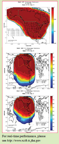
WAAS provides Localizer Performance with Vertical guidance (LPV) capability to 200 feet decision height in the coterminous United States (CONUS) and Alaska. WAAS also provides Required Navigation Performance (RNP) capability throughout North America and for much of South America.
What are your plans for dual frequency operations?
The United States Government (USG) Federal Register Notice states ‘sunset’ for L2 P(Y) signal use in December 2020. WAAS plans to support a dual-frequency service when WAAS transitions from L2-semicodeless to the use of L5. As such, the FAA is currently modifying the WAAS infrastructure to support receipt and processing of the L5 signal. The FAA plans to test and validate dualfrequency algorithms when sufficient L5 signals are available. The dual-frequency service will improve the availability and extend the service area for LPV-200.
Explain the significance of transition from L2 to L5?
The transition from L2 to L5 within the WAAS will need to be completed prior to the sunset of the L2 P(Y) signal and will require that 24 GPS satellites are operationally broadcasting the L5 signal.
How do you look at the issue of interoperability in view of emergence of several SBAS?
The expectation is that emerging SBAS providers will develop and check interoperability as part of their SBAS’ approval process. SBAS that follow the International Civil Aviation Organization (ICAO) Standards and Recommended Practices (SARPS) should be compatible and usable by all airborne equipment. Recent FAA flight testing demonstrated the capability of approved SBAS avionics equipment to transition between WAAS and EGNOS. Presumably, any compliant SBAS whose signal meets the existing standards can be used.
What are your plans in developing the user standards?
User standards are developed jointly with industry through the RTCA Special Committee 159 on GPS and GPS augmentations. The FAA plans to support the committee activities. The FAA is also working with the SBAS Interoperability Working Group (IWG) on a definition document that provides the basis for interface design and Minimum Operational Performance Standards (MOPS) development for L1/L5 and multi-constellation. The current goal is to have a Dual- Frequency Multiple Constellation (DFMC) MOPS available in 2018.
What are the key issues in international collaboration?
The SBAS IWG was established by the SBAS service providers to provide a forum for international collaboration and to address interoperability questions. The IWG is currently working to define key aspects of the Dual-Frequency Multiple Constellation (DFMC) SBAS. The key issue is ensuring that the written requirements are interpreted consistently. Based on the successes of SBAS IWG collaboration in the past, successful collaboration is expected on this issue.
What are key commonalities between WAAS and GAGAN?
Both WAAS and GAGAN have been developed to be ICAO SARPS compliant. As such, key commonality is compliance with the SARPS and broadcast of standard SBAS messages. Operationally, the expectation is that GAGAN will operate and behave in a manner similar to WAAS.
Many of the same organizations that have supported the development of GAGAN have supported the development of WAAS. This includes, but is not limited to, Raytheon, Stanford University, and MITRE.
What has been FAAs’ association with the development of GAGAN?
The FAA’s association with the development of GAGAN has been similar to its involvement with other SBASs. The FAA was not directly involved with GAGAN development, but does share technical knowledge and lessons learned with GAGAN and other SBAS service providers throughout the world. The purpose of this collaboration is to grow global SBAS coverage and ensure interoperability.
How vulnerable is WAAS to the threats of jamming, interference and spoofing etc?
There are multiple studies and reports available on the impact of jamming, interference, and spoofing of GPS receivers. WAAS has experienced episodes of interference at several reference station locations but due to the distributed nature of the WAAS reference stations and the data validation and integrity monitors, WAAS service availability has not been impacted.
Besides aviation, how has WAAS benefitted other segments users?
Even though WAAS was designed for aviation, it is widely used for nonaviation applications. WAAS is used extensively for mapping, surveying, shipping, and boating. For example, municipalities across the U.S. use WAAS survey receivers to map assets such as fire hydrants, road markings, light poles, and other items. WAAS has been used in the Puget Sound, in Washington, to precisely locate derelict fishing gear and crab pots. Additionally, many recreational boaters and shipping companies have transitioned to high-performance GPS L1 receivers, using WAAS optimized for non-aviation users, to help them navigate safely into harbors. As more applications are identified, WAAS use continues to grow within the non-aviation sector.
“The current MSAS provides horizontal navigation only”
 |
|
What is the current status of MSAS?
The MSAS has been operational since September 27, 2007. Japan Civil Aviation Bureau (JCAB) began the MSAS program in 1993 and launched the first and second geostationary satellites for the MSAS in 2005 and 2006.
They also have aeronautical communication and weather observation missions. The MSAS consists of 2 geostationary satellites, MTSAT-1R at 140E and MTSAT-2 at 145E, 2 MCS (Master Control Station) in east and west parts of Japan, 4 GMS (Ground Monitor Station), and 2 RMS (Ranging and Monitor Station) in Hawaii and Australia.
The current MSAS provides horizontal navigation only due to the ionosphere problem. The vertical navigation is not supported by the MSAS because the ionosphere at the low magnetic latitude region including the southwestern islands of Japan is highly active and affects the propagation of radiosignals.
Who uses MSAS?Can you give some idea about your user segment in addition of aviation?
In the aviation sector, the most of MSAS users come from general aviation. Some regional commuter planes and general aviation planes equip SBAScapable navigation sensors. In Japan, SBAS is available as a primary navigation source for approaches and a supplemental navigation for enroute. 40 RNAV and RNP-AR approaches are available in Japan as of May 31, 2013.
In other sectors, many people, including cell phone (and smart phone) users, may implicitly use the MSAS through SBAS-capable GPS chips.
What are concerns and challenges before MSAS?
The ICAO (International Civil Aviation Organization) adopted FANS (Future Air Navigation System) concept in 1991 which clarified the necessity of transition to usage of satellite navigation systems. In this context, GPS-based navigation looked beneficial in terms of coverage and cost because they would be able to reduce conventional ground-based navigation aids. Thus, JCAB decided to introduce satellite-based navigation by implementing the MSAS as an infrastructure of navigation supporting the whole airspace of Japan.
Would you like to explain the concept of dual frequency SBAS?
Dual frequency SBAS is an essential solution against the ionosphere problem which is the major error source limiting the performance of the SBAS.
As you know, in terms of aviation, ‘dual frequency’ means usage of L1 and L5 civil signals both within the ARNS bands. Additionally, considering the sunset of L2 P/Y signal, usage of L1 and L5 for dual frequency operation is a realistic way.
Unfortunately, MTSAT-1R and MTSAT-2 have no transponders for L5 frequency. The plans for supporting L5 have not been decided yet.
How do you look at the issue of interoperability in the context of MSAS?
Flight crews have little knowledge on which SBAS is used in operation because the onboard FMS automatically choose SBAS to be used.
In such a situation, each SBAS must meet required navigation performance at least for enroute at everywhere in its broadcasting coverage regardless its intended service area. In addition, using SBAS operated by another state involves some legal issues.
In particular, MSAS will have many other SBAS whose coverage is overlapping with MSAS in near future; Russian SDCM, Korean SBAS, and Chinese BeiDou are planned to broadcast SBAS signals. They might have some interoparability issues, for example switching SBAS, with a dependency upon avionics.
“The K-SBAS is expected to be declared operational for open service in the year 2018”
 |
|
What is the basic structure and coverage area of proposed SBAS system of Korea?
The objective of the K-SBAS program is to implement a certifiable SBAS system providing APV-I service in Korea for the benefit of civil aviation users in the Korean air space using satellite-based navigation. When commissioned for the target of APV-I SoL service, the K-SBAS will provide a civil aeronautical navigation signal consistent with ICAO’s SARPs for seamless aircraft navigation.
The preliminary configuration of K-SBAS comprises:
– 5+ wide area reference stations which collect measurement data (GPS L1/L2 and GEO L1) and forward to central processing facilities
– 2 Central processing facilities which carry out correction, safety, and SBAS message processing
– 2 Central control facilities in which the tasks include system control and maintenance, system status and performance monitoring, performance analysis, support to users, etc.
– 2 GEO uplink stations which format navigation messages for GPS compatibility and transmit them to the GEO satellites, and also provide ranging capability
– 2 GEO satellites to be leased which will receive a navigation signal in C-band and transmit GPS L1 compatible navigation signal
The coverage area serviced by K-SBAS will be the South Korea region, and the K-SBAS area-of-coverage performance objectives are to provide a primary means of navigation service for all phases of flight, ranging from en-route through precision approach within the area and to expand the benefits of SBAS to non-aviation users including car navigation, LBS, etc.
When it is likely to be operational?
Tentatively, the K-SBAS is expected to be declared operational for open service in the year 2018 and its full operational capability will be likely reached at the year 2019-2020. Subsequently, the K-SBAS delivering a Safety of Life service for aviation is expected to be made from the year 2022.
What are the likely benefits of the proposed SBAS of Korea?
It has been required the propulsive strategy for gearing up the change of the nation’s current air traffic surroundings and handling future demand in Korea due to the fact that:
– Overall air traffic volume in Korea increases annually by a factor of 7.3%
– Expected air traffic volume in Incheon Airport will be from 160,000(FY2005) to 490,000(FY2025)
– Expected air traffic volume in Incheon FIR will be 1,033,000(FY2025)
– It is difficult to install additional conventional air traffic infrastructure due to limited air space available
– It keeps increasing the request of precise position information in nonaviation use (car navigation, LBS, etc)
Thus, K-SBAS will play an important role in Korea airspace modernization and be a key technology for improving the efficiency of Korea airspace operations. We believe that it has the potential to modernize the airspace, reduce flight delays, save fuel and improve safety of flight over such congested Korean Flight Information Region. In addition, it can be expected a huge benefit over existing navigation infrastructure for aviation.
How do you look at the interoperability issues with other operational SBAS?
Although all SBAS are currently defined as regional systems, it is commonly recognized that there is a need to establish adequate cooperation/ coordination between the different systems, so that their implementation becomes more effective and part of a seamless worldwide navigation system. To guarantee seamless and worldwide system provision and clarify/harmonize technical implementation issues which may have an impact on the adequate interoperability of SBAS systems, we plan to attend Interoperability Working Group (IWG) meetings regularly. With that respect, specific requirements could be included in K-SBAS so that interoperability with those systems may be achieved.
Also, during initial and final operational phase, international assistance will be sought for the definition of interoperability for K-SBAS, system validation, testing, and certification.
Since there is an operational SBAS in neighboring region, how the Korean SBAS is going to complement the overall efforts regarding SBAS in the region?
It has not been examined regarding a detailed consideration on harmonization/ cooperation with an operational SBAS in neighboring region and further study on such issue will be carried out after the initiation of the K-SBAS program.
“IWG targets the development of dual frequency multi constellation (DFMC) SBAS”
 |
|
Would you like to highlight the Standards and Recommended Practices (SARPs) of ICAO?
The SBAS SARPs in Annex 10 Volume I are the basis that ensure uniformity and interoperability across different implementation of SBAS and a seamless transition between SBAS service areas. Standardized procedure design criteria for SBAS approach are contained in ICAO Doc 8168 (PANS-OPS). Coordination of technical developments on SBAS is conducted at the international level by the Air Navigation Commission through its Navigation Systems Panel, which involves a large number of States at the global level. Coordination of SBAS implementation at the regional level is conducted by the relevant PIRGs.
What are the objectives of SBAS interoperability group?
SBAS interoperability group is not an ICAO group, but an informal group coordinated by FAA and ESA.
SBAS operators meet regularly in this group (IWG) to conduct informal coordination of operational issues and technical development as required, and GBAS operators meet similarly in the GBAS IWG. These informal groups have proven their relevance by their early work on interoperability issues, which feeds in turn Eurocae/ RTCA publications. They also work in close liaison with the ICAO NSP.
Please highlight the key benefits of SBAS.
By providing differential corrections, extra ranging signals via geostationary satellites and integrity information for each navigation satellite, SBAS delivers much higher availability of service than the core satellite constellations with ABAS alone. In certain configurations, SBAS can support approach procedures with vertical guidance (APV) and in many cases lower minima than those associated with non-precision approaches, resulting in higher airport usability.
SBAS may also enable States and their Air Navigation Service Providers to decommission progressively ground-based navigation aids for en route and terminal operations, guided by associated safety and performance cases as necessary, which would in turn reduce their operating costs.
What are your plans in developing standards to support the dual frequency multi-constellation users?
From 2020 GNSS receivers capable of tracking multiple frequencies and multiple core constellations are expected to become available. This is a great opportunity for aviation users to increase the global safety and performance of GNSS based navigation.
As part of its work plan, IWG targets the development of dual frequency multi constellation (DFMC) SBAS. The ICAO Navigation System Panel will make use of IWG results when developing the DFMC SBAS SARPs. The IWG through its working group on ionospheric matters is contributing to identify new mitigation techniques for propagation delays and scintillation but also… new failure modes. Probably at that time, ionospheric disturbances will then contribute for much less to the TSE (total system error).
Nevertheless, considering the pace and cost to equip the worldwide aircraft fleet with multi-constellation/multi-frequency receivers, navigation during Solar Cycle 25 (2019-2030) may still mostly rely on single frequency/constellation user equipment for more than one decade, with all associated challenges.
What are key priorities and challenges?
Key priorities:
Performance based Navigation based on GNSS is already providing significant improvements in safety, regularity, efficiency and economy of air transport. GNSS provides a foundation for seamless global ATM system upon which States can deliver improved services to aircraft operators. A recent development illustrating this is the certification of GAGAN SBAS augmentation system to RNP0.1 for En route and Non Precision Approach.
In the APAC Region particularly, PBN Terminal will be proposed for endorsement to the next APANPIRG in September 2014 as the priority one among seven Top Priority items:
• All international high density aerodromes should have RNAV 1 (ATS surveillance environment) or RNP 1 (ATS surveillance and non- ATS surveillance environments) SID/STAR by end 2015
• Where practicable, all high density aerodromes with instrument runways serving aeroplanes should have precision approaches or APV or LNAV by end 2015.
The Navigation Strategy for the Asia and Pacific Region adopted by APANPIRG/24 in June 2013, was revised accordingly:
• implement GNSS with augmentation as required for APV and precision approach or RNP AR (Authorisation Required) operations where it is operationally required and economically beneficial; implement the use of APV operation in accordance with the Asia/ Pacific Seamless ATM Plan;
• rationalize terrestrial navigation aids, retaining a minimum network of terrestrial aids necessary to maintain safety of aircraft operations.
SBAS expansion can help reaching those objectives.
But the Asia-Pacific aviation community is also relying more than ever on a single frequency GNSS infrastructure which needs to be robust against threats like ionospheric effects, until the future multi-constellations are operational and used by a majority of airspace users.
Key challenges:
Hence one key challenge in the meantime is the need for robustness of this GNSS-based infrastructure which was fully acknowledged by the 12th Air Navigation Conference specifically through its Recommendation 6/9 – Ionosphere and space weather information for future global navigation satellite system implementation and its Recommendations 6/7 (Assistance to States in mitigating global navigation satellite system vulnerabilities).
Through this recommendation the global aviation community has accepted to study the optimum use of space weather information that is globally applicable from low to high magnetic latitude regions for enhanced global navigation satellite system performance at a global context.
En route and terminal area navigation services prove to be robust against ionospheric delay effects such as those caused by severe ionospheric storms or by unique equatorial phenomena. This robustness is due mostly to the relatively large alert limits associated with those flight operations.
However, for APV SBAS approaches in low-latitude areas, the variability and unique phenomena of the equatorial ionosphere reduce the availability of APV service. Severe ionospheric scintillation may sometimes cause temporary losses of service, particularly in low latitude. But the severity of the service degradation as a function of solar activity, geographical area and number of core constellation satellites has not been characterized in detail. Here again we need sufficient statistical history. Such characterization may be needed by some States so as to assess how far they should maintain a certain number of ground-based radio-navigation systems in order to mitigate the risk of loss of GNSS service due to ionospheric scintillation effects, while relying on single frequency SBAS, and if needed, new regional ionospheric threat models could be built and implemented by system suppliers and navigation service providers, be it for SBAS or GBAS.
In this regard the ICAO Ionospheric Task Force, chaired by Dr. Susumu Saito, senior researcher from ENRI, Japan, is already bringing a great contribution from the APAC region by characterizing the effects of ionospheric activity in the APAC region and assessing the need for regional ionospheric threat models.
Another challenge faced by airspace users is the cost of equipment, training and certification associated with SBAS, whilst valuable alternatives are often available: ABAS-based procedures for en route and non precision approach, and APV Baro for approach procedures with vertical guidance, provided a local altimeter reference (QNH) is safely managed .


 (3 votes, average: 1.67 out of 5)


Leave your response!