Articles in the Articles Category
November 2010
European Lidar Mapping Forum
30 November – 1 December
The Hague , Netherlands
www.lidarmap.org/ELMF/
February 2011
ILMF 2011
7 – 9 February2011
New Orleans, LO, USA
www.lidarmap.org/ILMF.aspx
16 International Geodatic Week
13- 19 February 2011
Obergurgl, Austria
www.geodaesie.uibk.ac.at/obergurgl.html
March 2011
The Munich Satellite Navigation Summit 2011
1-3 March
Munich, Germany
www.munich-satellite-navigation-summit.org
GEOFORM-2011
15-18 March
Moscow, Ecocentre Sokolniki
www.geoexpo.ru/defaulteng.stm
April 2011
Geo- Siberia 2011
27-29 April
Novosibirsk, Russia
www.geosiberia.sibfair.ru/eng/
May 2011
ASPRS 2011
1 – 5 May
Milwaukee, Wisconsin, USA
www.asprs.org/milwaukee2011/
Gi4DM 2011
3 – 8 …

For all the three pillars of space geodesy (the geometry of the Earth surface and its displacements, the orientation of the Earth axis and its rotation speed, and the Earth’s gravity field and its time variations), well-defined, highly accurate and stable global Earth-fixed and celestial reference frames are of primary importance. Over the last decade considerable changes took
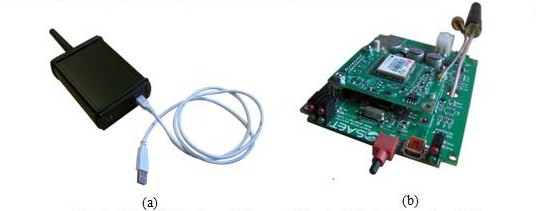
Gianluca Falco, Fabrizio Dominici, Gianluca Marucco, Antonio Defina
The integration of navigation and communication functionalities is one of the key elements exploited in new location-based systems and services
GNSS technologies are progressively becoming one of the key elements in most of innovative wireless applications. Most location-based services and systems are in fact …

Global Positioning System (GPS) provides precise timing, position, and velocity information by utilizing the constellation of satellites and a remote receiver that uses range measurements to the satellites and spatial trilateration techniques. In addition, more navigation satellite systems including Russia’s GLONASS, Europe’s Galileo, and PRC’s Compass will be available for the coming years. Those systems will form the mainframe of future Global Navigation Satellite System…

After the euphoria over the successful Chile mine rescue it is time to analyze the incident and ponder on the lessons learned.
Mines and accidents have been intertwined since time immemorial. But the Chile mining accident has become a watershed. Not because of the accident itself – this was no different from the many that have …
says Paul Verhoef Programme Manager, EU satellite navigation programme, European
Commission, Brussels, Belgium while emphasising on the difference between Galileo and
other GNSS systems
What is the status update on Galileo and in what stages will it become operational?
We are currently defining our initial operational capability (IOC) in detail.
Initially some services will be available which will not …

a
Compass and Galileo.
Apparently heading for a ‘head on’,
On frequency and signal issues.
In a world of multi GNSS systems,
With different priorities and agendas,
Such differences are inevitable.
But we do need a compatible and interoperable environment.
At the same time, we do live with conflicts and coexist.
Don’t we?
Bal Krishna, Editor
bal@mycoordinates.org
Tweet
An interview with Charles Branch, Portfolio Manager, Radio products, Pacific Crest Corporation
“The Gold Standard in Communications and Positioning.” What are the efforts that go into maintaining the ‘standard’ at Pacific Crest?
The efforts are towards:
• Increasing range by use of cleaner signal and greater receiver sensitivity
• Increasing operational efficiency by use of smarter protocols
• Increasing throughput by use …
says Mr. Swarna Subba Rao, Surveyor General of India about the upcoming agenda for Survey of India.
As the Surveyor General of India what are your immediate priorities for Survey of India?
Survey of India is India’s National Survey and Mapping Organisation and is the oldest scientific department of the country. In the years since its establishment …
With the evolution of technology.
GIS, GPS, LiDAR, mobile mapping, …
And changing societal needs for spatial information.
Google maps, in-car navigation, PDA, iPods, iPads, …
Facebook, twitter, smart phones, …
The role of surveyors needs to evolve.
From ‘product orientation’ to data analysts,
Quality control and quality assurance specialists.
The change has begun.
Adaptation is inevitable (read page 7).
Bal Krishna, Editor
bal@mycoordinates.org
Tweet


 (5.00 out of 5)