Articles in the Articles Category


The standard for productivity in 3D Laser Scanning extrapolates to a few key factors: area coverage, point density and spatial accuracy. The total workflow to produce…

The vulnerability of GNSS to radio frequency interference and spoofing becomes more and more of concern for navigation applications which require a high level of accuracy and reliability…

A major disaster puts any land administration system at risk of failure at the time it is most needed. This paper addresses the lessons that Nepal may learn from 2 quite…

The requirements on human resources in GNSS are at least two-fold: On the one hand very specialized engineers are needed; on the other hand generalists are needed…
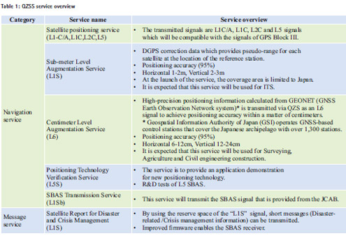
On November 18, 2015, the Quasi-Zenith Satellite System Service Co., Ltd. (QSS) conducted an experiment in Kyoto, Japan using a quasi-zenith satellite system…


The Geospatial Division includes a diverse set of solutions for geospatial data capture and analysis. The solutions range from all types of GNSS devices to total stations and laser scanners, from mobile…

A strong earthquake (7.8 RS) hit Nepal in 11.55 am Saturday, April 25, 2015 with epicenter in an area near Barpak village, Gorkha district, which followed by many powerful aftershocks…

In this paper, I would like to discuss the current situation of the working environment for young surveyors based on the contents of such reports…


 (5.00 out of 5)