Articles in the Articles Category


Of course, it would be extremely rare, when any GPS surveying and/ or “navigating” to the North Pole is undertaken. One such opportunity occurred In April 2005. British explorer Tom Avery in his effort(s) to recreate Adm. Robert Peary’s epic journey of April 1909 to North Pole took GPS to navigate himself…

Indian Institute of Surveying and Mapping (IISM) is the country’s premier institution for human resources development in the realm of surveying and mapping in its modern incarnation. IISM recognizes that the cutting edge in the process of development is information dissemination. Hence, its efforts of generating awareness among various organization and training its manpower in modern trends in Surveying & Mapping like GPS, Total Station,…
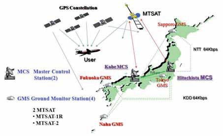
The Multi-functional Satellite Augmentation System (MSAS) is a Japanese Satellite Based Augmentation System (SBAS) [1] which provides Differential GPS (DGPS) corrections and is designed to supplement GPS by reporting and monitoring the reliability and accuracy of GPS signals in real time. MSAS consists of two satellites, (MTSAT-1R at 140E longitude and MTSAT-2 at 145E longitude), four Ground Monitor Stations (GMS), two Master Control Stations (MCS),…

Could you highlight the strengths of Vexcel Imaging large and medium format camera’s for our readers.
The strength of Vexcel is outstanding market knowledge, unparalleled technical experience and the attitude for innovation, all combined to maximize the customer benefi t of our products. Vexcel entered the market of digital large format aerial cameras in 2004, about three years later than the competition with a new concept, the UltraCam. Since then we have increased our market share constantly and became the market leader quickly – we have sold more than 125 UltraCams and additionally quite some camera upgrades. Obviously the market has decided for frame cameras and has made the UltraCam the most successful large format camera series.
Is the name DAT/EM an acronym, or is there some other signifi cance behind it?
DAT/EM (pronounced dāt’-əm) is an acronym for Digital Automated Technology / Engineering Mapping. The software was developed internally between 3 production mapping fi rms located in the United States in the mid 1980’s. As such, our software was conceived in a production environment to meet the demanding technical needs of top-fl ight photogrammetric organizations. Since the fi rst data collection licenses were sold in 1987 (on analogue stereoplotters), we have never lost sight of the need for constant improvement of the software. We have always understood if the software tools can save a user one key-stroke (or more!) on a repetitive command, this will have a direct and positive infl uence on the company’s profi tability.
August 2009
Bentley Be Connected Online Seminars
23 July-30 Nov.
www.bentley.com/BeConnected
September 2009
2nd GNSS Vulnerabilities & Solutions Conference
Sept 2 to 5, 2009
Baska, Krk Island, Croatia
http://twitter.com/BaskaGNSS2009

GPS import in India was derestricted in Jan,04 – Bal Krishna, june’05
If we go strictly by rule that exists on paper, making a GPS operational without a license from WPC is not allowed – P. K. Garg, July’05If GPS needs a license to operate in India then what is the procedure
for obtaining that license – Sudipto Roy, Jan07
It was easy to have detected Sumatra Offshore Earthquake from GPS – Shunji Murai and Harumi Araki, July’05 Rapid data acquisition and information services have contributed greatly to the rescue work and disaster relief efforts in Wenchuan Earthquake – Deren Li, July’08

Basic Act on the Advancement of Utilizing Geospatial Information was approved by the cabinet in Japan last year. It states the promotion of the various kinds of the applications of geodetic information in both private and public areas to realize the convenient and safe society. The supplementary budget to save the economical crises this year in Japan prepares a lot of money to promote the utilization of geographic information. In order to realize such society in near future,…
This conference is a milestone in our GSDI journey. The huge size of the conference program points to the relevance and level of interest in the subject areas of the conference partners. The conference has shown, once again, the essential requirement for the Association to partner in order to delivering credible outcomes, with INSPIRE and Geonovum at this event, as we did with FIG in GSDI 9.

Fifty months ago, the journey started.
With passion, confi dence and conviction.
All the while, we navigated through technology trends.
Raised issues and followed up.
Captured the pulse of the market.
Added dimensions to the domain (refer page number 16).
Presence was felt, impact is notable.
And the journey continues…


 (5.00 out of 5)