.

Oct 2007 | Comments Off on Facilitating land-sea interface through seamless SDI
figure10

THE land-sea interface is one of the most complex areas of management in the world consisting of both the marine and terrestrial environments. The coastal zone is also home to an increasing number of activities, rights and interests. Population along the coastline is continuously increasing, bringing about new pressures on the fragile eco-system of the coastal zone. This has brought with it an increased need to more effectively and efficiently manage this area to meet the economic, environmental and social outcomes of sustainable development.
Aug 2007 | Comments Off on Managing land information
aug07_fig1

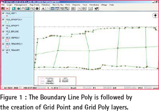
LAND forms important part of development activity. Land revenue is one of the sources of income for state governments. It may come from land holdings by private individuals, real estate transactions or other natural resources being tapped by various sections of the society. Hence, creation of a Land Information Management System involves

Dec 2019 | No Comment

The Northern Territory (NT) has been able to introduce innovative digital survey and cadastral management for Land Administration….

Oct 2019 | One Comment

The Centre for Spatial Data Infrastructures and Land Administration (CSDILA) at the University of Melbourne, Australia, has been chosen…

Feb 2017 | No Comment

The joint FIG/World Bank Publication states that Fit-for-purpose means that the land administration systems…

Jul 2016 | No Comment

In all development cooperation projects in the field of land administration, initially, the particular national and regional characteristics must be considered…

May 2016 | 5 Comments

Activities for land administration, cadastral mapping and registration of real property rights in the Republic of Kosovo are priority components for the country’s economic development strategy…

Aug 2015 | No Comment

The main reason for FAO’s initial involvement in open source land administration software was that in the developing world, the move from paper based tenure records and related processes to computerized systems based on digital data flows had been slow, costly and often unsustainable.

Oct 2012 | No Comment

Educating surveyors: Some of the challenges:John Hannah;

Key demands for sustainable land administration: Stig Enemark;

Improving cadastral survey procedures using crowd sourcing techniques:Sofia Basiouka, Chryssy Potsiou;

Jul 2012 | No Comment

Significantly, this was the first annual conference that dedicated a specific stream to spatial information. The full day workshop convened by the International Federation of Surveyors (FIG) and the World Bank “Spatially Enabling Government and Societies (SEGS) for Sustainable Land Administration and Management” was an excellent complement to the overall conference theme on land governance.