| Applications | |
Enabling Technology for Citizen and Community Tenure Rights Protection
This paper outlines the progress of the FAO SOLA open source software over the past four years and how it has evolved from a system supporting registration and cadastral functions in a typical land offi ce as a result of its implementation in 6 countries (including 7 states in Nigeria) |
 |
|
 |
|
 |
|
The main reason for FAO’s initial involvement in open source land administration software was that in the developing world, the move from paper based tenure records and related processes to computerized systems based on digital data flows had been slow, costly and often unsustainable. A different approach was required to one based largely on proprietary software and repeated software development initiatives in different countries providing similar functionality that mirrored paper based processes. Out of the initial FAO ‘Solutions for Open Land Administration’ (SOLA) project came a system that provided support for registration and cadastral functions in a typical district land office and a small open source community (Pullar et al, 2012). The initial SOLA solution (now called ‘SOLA Registry’ was piloted successfully in Nepal, Samoa and Ghana involving local teams of software developers during 2012 (Pullar, 2013).
The SOLA piloting effort coincided with the Committee on World Food Security’s endorsement of the Voluntary Guidelines for Responsible Governance of Tenure of land, fisheries and forests in the context of national food security (VGGT) in May 2012 (FAO, 2012). With this endorsement, FAO took on a lead role in the global effort to assist countries, especially in the developing world, to implement the VGGT. In that role, FAO recognized very early that many of the principles encapsulated in the VGGT implied the use of technology including the use of computerized systems. For instance, it is expected that land administration agencies any where in the world must facilitate transparency in the authoritative tenure records they hold and also in the performance of the services they deliver to the public. Current expectations of transparency imply as a minimum computerized indices and computer generated reports. Most commonly transparency implies computerized access to actual tenure records and service delivery by land administration agencies. In this way (and others) land administration agencies can provide greater tenure security to the public they serve.
The VGGT do not just apply to formal land administration and they are not just about the governance of land tenure. Considerably more land and other tenure arrangements exist outside of formal systems such as land administration systems and as a result poor and vulnerable groups have limited access to formalized forms of tenure security. For land tenure, the most common approach to address this lack of tenure security has been systematic registration programs. However, such programs are expensive and countries struggle to afford them without the funding that comes from development assistance support. There have been other attempts to address this problem with community property mapping initiatives but these too are often very dependent on external assistance and cease to operate when that external assistance is no longer there. The protection of tenure rights outside of formal systems rely on community recognition of those rights and in stable situations there are adequate and appropriate forms of tenure protection within the community structure. However, today, most societies are undergoing rapid change and facing many new challenges which weaken measures that may have protected tenure rights in the past. There are also new situations with few, if any, measures to protect tenure rights of vulnerable sectors in society. Responsible governance of tenure (and all that this means) provides the mechanisms to improve the protection of the rights of the vulnerable in these situations.
The VGGT specifically challenge countries to provide mechanisms:
• to identify and safeguard tenure rights not recorded by formal systems;
• to engage with all tenure rightholders in tenure governance processes including customary tenure rights not currently protected by the law;
• to exercise self governance for communities with customary tenure systems;
• to provide protection against unauthorized use of land, fisheries and forest resources;
• to ensure citizen and community involvement in State processes impacting on tenure rights; and
• to support participatory, gender sensitive processes impacting on tenure rights.
With this in mind, FAO in the last year, with the support and funding from its resource partners, has continued its work in developing and making available more and better open source software solutions that provide countries with a greater range of excellent enabling technology options as they devise plans as to how they will implement the VGGT in a way that provides tenure security to all sectors and especially weak and vulnerable groups within society.
SOLA implementations
As well as improving one country’s land administration system, each implementation of SOLA has increased the international SOLA open source community, resulted in more and better software functionality within the generic version of SOLA software and given FAO a better appreciation of what the needs are for future extensions to SOLA. It has also reinforced the importance of training and using local software developers in the software customization that is required to ensure SOLA complies with local laws, regulations, administrative processes and can deal with local tenure records. An essential element in maximizing the likelihood of a sustainable solution is the availability of local software developers capable of providing as a minimum first level software support and ideally, in the future, for these local SOLA software developers being able to extend and modify the customized version of SOLA when new demands are placed upon the SOLA based system.
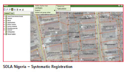
Nigeria
FAO’s engagement with the Nigeria Presidential Technical Committee on Land Record (PTCLR) and the GEMS3 project pilots for systematic land title registration (SLTR) (funded by UK DFID) came to an end in December 2014 after more than two years. During that time the SLTR processes were piloted and the SOLA systematic registration functionality refined as lessons were learnt. Originally there were SLTR pilots in just two states (Ondo and Kano) but because of interest from other states, SLTR was scaled up in six further states (Kaduna, Kogi, Jigawa, Cross Rivers and Katsina), all involving SOLA. There were challenges in trying to meet the needs of each state, especially concerning the format of ‘Certificates of Occupancy’ and the acceptance of the ‘general boundaries’ approach to define parcel boundaries. Claims that SOLA was ‘inflexible’ often masked a reluctance to change from old and quite dated practices that were neither sustainable in the longer term nor compatible with responsible governance. The parallel effort to produce a SLTR manual defining SLTR processes was helpful in producing a single version of SOLA for Nigeria SLTR that will minimize the software support effort while still giving states the ability to have their own format for Certificates of Occupancy. Over 20 SOLA support and software developers were trained in the time of FAO’s engagement with the PTCLR and GEMS3 SLTR work. SOLA also proved its ability to be modified easily to handle changing SLTR processes and to facilitate at low cost the quick scale-up of SLTR in other states.
The challenge now in Nigeria is to provide the state governments undertaking SLTR work with the ability to maintain the data collected through SLTR in a computerized system within state government Deeds Registries.
Lesotho
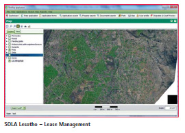
In Lesotho, late in 2012, the Land Administration Authority (LAA) (utilizing funding provided through the Millennium Challenge Corporation (MCC) compact with the Lesotho Government) was faced with the failure of a contract to develop a lease management system; one of the main initiatives to establish a modern land administration agency in Lesotho. The need for an urgent alternative solution was required given the MCC compact finished in August 2013. SOLA was seen as the only option given the available time and budget. This confidence in SOLA was well placed and in a little over 6 months an operational system was developed and implemented in the LAA. Using a team of local software developers supported by the FAO SOLA developers, the cadastral and registration functionality in SOLA was not only customized for Lesotho, but SOLA was also extended to include lease preparation and management functionality, an interface with the LAA corporate finance system to facilitate the collection of ground rent payments, the loading of data from the systematic registration project and the incorporation of the LAA’s orthophotos as a layer within SOLA. The challenge with this SOLA implementation has been that with the abrupt end to funding (with the end of the MCC compact) FAO support to the LAA has been limited to remote support. Normally there would have been at least a 6 month period of support including in-country support from FAO but that has been not been possible. There are plans for FAO SOLA support for further streamlining of lease management processes including integrated scanning functionality and replacing Geoserver as the means to publish LAA orthophotos with Mapserver (another open source solution).
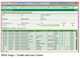
Tonga
Following a Royal Land Commission of Inquiry in 2010, the Tongan Ministry of Lands, Environment, Climate Change and Natural Resources initiated the Land Administration Project with the goal to significantly reduce the backlog of land applications while also improving the governance, accessibility and transparency of all land related dealings in Tonga. It also provided for greater protection of the paper records (deeds, leases, etc.) and reduce the risk of damage or destruction in case of a disaster. The Ministry realised that automation through a computerized system would be a key component of the Land Administration Project and asked for FAO’s support to implement a customized version of SOLA. A 1 year project was approved for the implementation of a Tonga customized version of SOLA with the project starting in January 2013. The project included the training of local software developers in enterprise software development techniques, participation by the developers in the software customization process, as well as training of Ministry staff in the operation of the customized software.
A significant challenge for this project was recruiting local software developers. There is only a handful of experienced software developers in Tonga (a number of whom attended the SOLA Software Developer Training) and none were available to participate in the customization project. Fortunately a young and talented IT graduate had recently returned from overseas and was able to join the project team and assist with the customization.
The customization of SOLA Tonga was successfully completed in November 2013. SOLA was enhanced to support the feudal and lease based tenure system used in Tonga. Approximately 30,000 paper records have now been scanned and loaded into the new system. Apart from greatly improving the security of these records, the Ministry’s ability to search and access these records in response to property information requests has improved dramatically. The Ministry has engaged the local software developer involved in the SOLA customization and are continuing to enhance SOLA Tonga with remote assistance from the FAO SOLA Team.
Next SOLA release
The Easter 2015 release of the SOLA software not only incorporates improvements arising from the recent implementations of SOLA but also includes other further innovations.
The original SOLA software has been separated into 6 separate SOLA software applications each application supporting a different tenure related function. As well, all of these SOLA software applications have been given a new, fresh and common color scheme. SOLA has always had easy to implement multilingual support as a feature of the software but this support has not been implemented comprehensively until this release where SOLA has been made available in 9 different languages. Finally, SOLA Registry (the original SOLA software application) has been extended to incorporate a number of ‘Family Safeguard’ features to complement its comprehensive disaggregated gender reporting capability.
These new features in the SOLA 2015 Easter release are further described below:
The new SOLA family of software applications
Initially the SOLA software comprised of just one software application that supported registration and cadastral functions and over the last two years this functionality has been extended to cover land administration functions such as systematic registration, lease preparation and management and state land administration. With the release of Open Tenure (a software application for tablets to support a crowd sourcing approach to record tenure relationships by communities that is described later in this paper) in September 2014 it became apparent that the time was right to describe each land administration function supported by the SOLA software as a separate software application. ‘SOLA’ has been retained as the ‘family name’ because each of the new software applications uses or has a dependency on the same software architecture including the LADM based SOLA database schema.
The new SOLA software applications are:
• Registry providing enterprise wide support for registration and cadastral functions in a typical district land office including case management of applications through a client desktop application, network server based software and a LADM compliant database .
• Systematic Registration supporting systematic (first time) registration activity based on a project office with a simple local area network (LAN) including the production of public display listings and maps, the generation of title certificates and the digital transfer of this data to a district land office.
• Admin providing system administration functionality available as both a client desktop application and as a web based application. Used in conjunction with other SOLA software applications.
• State Land providing enterprise wide support for state land tasks including lease administration, acquisition and disposal of land and property and the management of state land and properties. Uses both a client desktop application, server side software and the extended LADM compliant SOLA database.
• Community Server hosts Open Tenure captured data, provides web access (and comprehensive searching) to tenure related map and attribute data, allows new property details to be captured without the need for mobile devices (by users with internet access through an internet café) and for community authorized individuals to manage Open Tenure related processes leading to the community recognition of property rights. Web based application typically involving a cloud based server, a LADM compliant SOLA database and an instance of GeoServer publishing (as a WMS service) any aerial or satellite imagery available for Open Tenure community tenure recording.
• Open Tenure provides for the inthe- field capture of property rights (including mapping) through tablet based software (Android and Applie iOS) and the uploading of these details to a Community Server. Existing tenure data and aerial (and satellite) imagery can also be loaded for offline operation. Online operation means that imagery sources such as Google Map can also be used where this is feasible.
Further SOLA software applications being considered for development in the coming year are:
• Mass Valuation supporting the systematic valuation (and revaluation) of particular categories of properties including the formulation of appropriate valuation models, the calculation of values, generation of listings of proposed new property values, dealing with objections to new property values and the dissemination of finalized property values.
• Public Access providing web based access to map and attribute data held in a SOLA database including details concerning titles, cadastral maps, images of registration documents and survey plans, public display listings (systematic registration, state land and mass valuation) and tenure related applications and service requests.
• Street Address providing for the capture of street centrelines, street names, property numbers and significant landmarks and the dissemination of this data.
• Forest Tenure an extension of SOLA Registry to deal with the administration of forest tenure rights
• Fisheries Tenure an extension of SOLA Registry to deal with the administration of fisheries tenure rights
Multilingual support
The Easter 2015 release of the SOLA software will include multilingual support in a number of the SOLA applications covering a range of languages as well as a software tool that can be used to incorporate further languages in the future. SOLA multilingual support allows for the on-the-fly language changes without the need to restart the software. Multilingual support covers the user interface, system messages, help files and reference table drop-down lists (with values taken from the SOLA database).
Multilingual support has focused on SOLA Registry where languages supported are English, French, Spanish, Portuguese, Russian, Chinese and Arabic. The SOLA Community Server and SOLA Open Tenure software applications also supports Albanian and Khmer (Cambodian). SOLA State Land supports Amharic (Ethiopia).
The hope is that now the need for a system within a language other than English is not seen as an obstacle for using the SOLA software or as a reason to develop a completely new system to support a land administration function.
Family safeguards
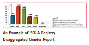
In computerised systems supporting land administration functions the need to address gender inequalities as related to tenure rights is a topical issue and its importance is reinforced in the VGGT (Principle 4, section 3B, Principles of Implementation, VGGT). Disaggregated gender ownership details are a standard reporting requirement on many World Bank funded land administration projects. Typically this reporting is based on the percentage of male and female owners but this is only helpful in confirming that inequalities exist. In a move to provide more insights into these inequalities and how they can be addressed, SOLA Registry has a disaggregated gender report format that provides greater detail on ownership gender groupings in the hope that this will facilitate bench-marking and the formulation of more targeted interventions to address gender based inequalities.
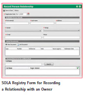
Another new feature in SOLA Registry has been to incorporate various ‘Family Safeguards’. While recognizing that legally backed safeguards protecting women and girls tenure rights vary from country to country, SOLA Registry, includes a facility to note a court domestic violence order and seal ownership details so that SOLA Registry cannot be used by an abusive partner to locate a former partner. It also provides another service where a spouse or dependent (including children) can record their relationship to a property owner and ask to be sent automatic notifications should a transaction be initiated on the identified owner’s property. While not necessarily being able to stop the transaction, it may allow a partner or child to initiate an appropriate legal action against the transaction progressing in the case of relationship break-down or inheritance should they consider that their tenure rights will be threatened by the transaction proceeding.
Evolution of SOLA software architecture
SOLA was originally designed using a layered architectural pattern based around interoperable web services. This was in large part due to the initial analysis identifying two key architectural principles:
1. Use modular loosely coupled and interoperable components
2. Use an Enterprise Application Framework (EAF)
At the time, the rational given for applying these principles were;
a. Loose coupling reduces the complexity of a system of interacting components. It allows making internal changes to one component without affecting other components. It improves availability and stability of the system since problems with one component are less likely to impact other components.
b. Components can be reliably changed more quickly than otherwise would be the case. Functional scope of the components is reduced which in turn reduces their complexity.
c. Interoperability enhances opportunities for reuse, reduces costs by reducing duplication of effort and reducing integration complexity.
d. Typically an enterprise architecture framework will comply with recognised standards ensuring interoperability and significantly reduce the overall coding effort required to produce reliable, scalable and performant enterprise applications. (McDowell 2011)
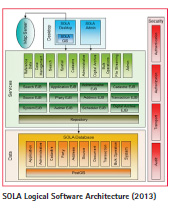
The overall goal was to create an architecture that could accommodate a broad range of functional requirements as well as support integration with existing enterprise systems. Between 2011 and 2013 the FAO SOLA development team set about applying these principles and developing SOLA to support registration and cadastral functions of a typical district land office. The following diagram illustrates a logical view of the SOLA software architecture as of 2013 prior to the implementation of the new suite of SOLA solutions. Apart from some minor additions this was consistent with the original architecture envisioned in 2011.
The diagram shows a three tier enterprise application based around web services. A two dimensional layering approach was used to structure the software firstly by responsibility and secondly for reuse. The three structural responsibilities are Presentation (Desktop), Business Logic (Services) and Data. The Business Logic and Data layers are further partitioned into business concepts using web services and Enterprise Java Beans (EJB’s) to promote reuse. Security of tenure data was also a primary consideration and industry standard approaches were used for all security aspects. External systems such as Map Servers were also integrated to enhance map navigation through geographic imagery.
Taking SOLA mobile
With the decision in late 2013 to pursue a mobile app for community recording of tenure claims, the FAO SOLA software development team realized that a review of the SOLA software architecture was required to establish how a mobile app could fit within the existing architecture. A mobile client was not something that had been fully considered during the initial analysis phase and the team assumed some changes to the architecture would be necessary. The review was undertaken by a mobile application expert who made the following key observations:
1) In the 2013 implementation of SOLA, SOLA was intended to work in a walled garden (ie an office local area network)
2) The integration for mobile devices would bring about the need for internet connectivity. The SOLA server was exposing a SOAP based web service interface towards its clients (such as the SOLA Desktop client application) so it was feasible to use the same interface for the integration of additional clients (mobile devices) providing there was the appropriate addition network equipment. There are, on the other hand, several considerations against taking this approach.
a. Security considerations Exposing the SOLA server directly over the internet would give no control over the type of capabilities that a remote client could access, unless a dedicated, channel aware, access control function was developed on the server itself. However such a function would expose the functionality, currently only internally available to users of the SOLA desktop client applications, to external threats such as DOS/DDOS attacks.
b. Operational considerations Having a single implementation for both local and remote access to SOLA functions, brings unnecessary functionality to organizations not willing to implement the mobile devices integration. However, a single point of service would introduce a source of cross impact from one access channel to the other. Stopping one service (e.g. deploying a new release fixing a bug only affecting one access channel) would produce an unnecessary downtime on the other.
c. Development considerations Major mobile applications software development kit (SDK) such as Google’s Android and Apple’s iOS) have poor support for interacting with SOAP based web services, requiring hand coding of XML building/parsing or additional, platform specific, 3rd party plugins for integration. Using SOLA server as an interface towards mobile devices would then result in either additional development on it or in additional complexity in the development of the mobile applications.
For these reasons, such an approach was not adopted and instead it was decided to implement REST/JSON based interface that was well supported in mobile platforms. Such an adaptation layer would allow mobile device access to the SOLA server SOAP based web services. Through the use of the same technology already used by SOLA components (Java/JEE), it would be easy to reuse the code implementing the SOAP/XML client in the development of such an adaptation layer. (Toma, 2014)
In addition to recommendations related to the support of mobile apps, the review identified that a web application (the Community Server) would be required to allow users to access and review claim information via the web. The review determined that the architecture and technology stack used for SOLA (Java/JEE) was suitable to support the development of this web application.
Current state
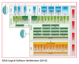
During 2014 the FAO SOLA development team proceeded to implement the Community Server, the Open Tenure mobile apps (for both Android and IOS) as well as the REST/JSON interfaces recommended by the Mobile Application Architecture Review. Automated email capability was added to support enrollment of Open Tenure Community users and new EJB’s were added to the SOLA Services layer to support Open Tenure (Claim EJB), improve service performance (Cache EJB) and reduce the number of inter-dependencies between the EJBs (Reference Data EJB). In the same period, the Systematic Registration, State Land and Web Admin solutions were also formalized and implemented. With the move to a suite of solutions under the SOLA umbrella, the original SOLA Desktop was rebranded to Registry.
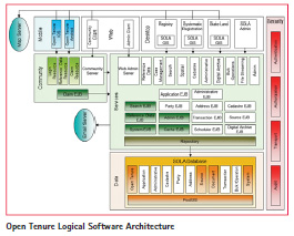
An important feature of this architecture is that although the components are fully integrated, each new solution only uses the components relevant to its function. For example, the logical architecture for the Open Tenure Mobile apps is shown below. Similar diagrams can be created for each of the new SOLA solutions highlighting the areas of component reuse within the architecture.
Although extensions to the SOLA architecture were required in order to support the Open Tenure Mobile apps, adhering to the original architectural principals established for SOLA has smoothed the transition to the new, more functional architecture. More SOLA solutions are planned for 2015 and the current state architecture will ensure those new solutions can be implemented quickly and effectively.
‘Open tenure’ -community tenure recording
Open Tenure is an open source software app for mobile devices that gives communities and individuals the ability to record tenure rights within their community. It is designed to be used in conjunction with a web based “community server” where tenure details captured with Open Tenure can be publicized and moderated by the community. It is the first SOLA software application to specifically address tenure recording at the community level outside of formal land administration. Although the related SOLA Community Server software uses the same SOLA software architecture and takes advantage of the original SOLA software components as has been explained earlier in this paper, the tablet based Open Tenure software application necessitated extensions to the overall SOLA software architecture and a different software development environment (Eclipse).
Another difference is that while FAO SOLA has recommended in-country (and preferably in-house) SOLA software customization effort and subsequent support for its other SOLA software applications, this is not the case for Open Tenure where the communities expected to use Open Tenure are unlikely to be able to afford that level of software development expertise. Open Tenure can be modified to reflect local needs but this will be a configuration exercise completed when Open Tenure is initially setup for a community and can be done by someone with system administration skills from a remote location.
Open Tenure takes advantage of more affordable technology in the form of mobile devices including tablets and smart phones that certainly in terms of the latter are common within many of these communities. The success of crowd sourcing in many situations (such as Open Street Maps) in developed countries has also been a reminder of the power of community and citizen based initiatives.
Other factors setting the scene for Open Tenure include:
• the success of the FAO SOLA open source software and the general acceptance that open source software provides serious software solutions;
• improved mobile phone network coverage in countries where FAO works;
• the availability of cloud based servers (to host and provide community access to the Open Tenure captured tenure details);
• the publication of the FIG/World Bank ‘Fit-For-Purpose Land Administration’ report that encourages the use of ‘aerial imageries’;
• the recent ratification of the Land Administration Domain Model (LADM) as an international standard (ISO 19152) and international exposure given to the Social Tenure Domain Model (STDM) as an extension of LADM to more easily accommodate tenure relationships found in customary tenures and tenure relationships in informal settlements; and
• the 2012 endorsement of the VGGT by the Committee on World Food Security.
Software development
A multi-national team coordinated from FAO Headquarters in Rome, has been involved in the development of Open Tenure and the other SOLA software applications. Initial design work for Open Tenure began in December 2013 with the Android version of Open Tenure released in September 2014. The first field test involving a community forest group in Cambodia began in February 2015. Another field test of Open Tenure with indigenous communities in Guatemala is being investigated for later in 2015.
Although other initiatives involved in improving the governance of tenure and in particular facilitating the application of Open Data concepts to property tenure rights (for instance MapMyRights Foundation – www.mapmyrights.org) are discussing the establishment of servers to receive, host and publicise tenure rights, no such servers are operating or designed yet. Given that the driver for the Open Tenure development work in FAO was to develop software that would support the crowd sourcing of tenure rights, it was necessary to develop both an in- the-field client app to run on mobile devices as well as a Community Server system that could store, provide access to and support the ‘office’ (non-field) community processes to moderate the collected tenure details.
For this reason, it was decided to capitalize on the existing SOLA software development effort and create a web version of SOLA, the SOLA Community Server. This component was developed using Java, the Netbeans IDE and involved extending both the SOLA software code (available at www.github.com/ SOLA-FAO) and the SOLA database structure. The FAO test version of the SOLA Community Server (based on a fictitious community on Waiheke Island) can be viewed once you register as a user at http://ot.flossola.org .
The Open Tenure client application for the Google Android mobile devices was written using Java but was developed using the Eclipse (Kepler) IDE, with the Eclipse Android Development Tools. The Open Tenure software code as well as the (apk) installation file is available through www. github.com/OpenTenure. Ultimately Open Tenure Android version will be distributed free of charge through the Google PlayStore.
Although Google Android is the most common operating system for mobile devices, Apple iOS also has a significant market share of mobile devices. For this reason, once the Open Tenure Android development was well advanced, a second development for an Apple iOS version of Open Tenure was started using the OSX xCode software development application. This iOS version of Open Tenure is expected to be available by the end of February 2015 through the Apple AppStore with source code also available through www.github.com/OpenTenure.
The transfer of data between the Community Server and Open Tenure is in JSON defined data packets which match up with LADM classes defining rights, restrictions and responsibilities (rrr), documents and sources, persons and spatial units. While the focus of Open Tenure is on community tenure recording and mapping in the informal sector, the data packages uploaded to the Community Server are stored in a separate schema within the SOLA database.
When Open Tenure is used within formal land administration there will be a need to modify this database mapping so that uploaded data is stored within regular SOLA database schemas.
In Open Tenure another mechanism (termed ‘Dynamic Form Generation’) has been incorporated to make it easy to add new fields, lists and data constraints to meet specific local requirements. Using a similar approach to the Open Data Toolkit, users themselves can make these changes in the SOLA (Web) Admin application without any software changes. Once the Open Tenure form changes have been defined, the next time Open Tenure connects to the Community Server, these changes will be reflected in the Open Tenure user interface.
A lot of thought has gone into software usability in the design of Open Tenure. Unlike desktop software applications where you have user manuals and context sensitive help to overcome any usability complexity, mobile device apps do not normally have these mechanisms. With mobile apps the need for intuitive and simple user operations is essential. If your software app has not ‘captured’ the user in their first few experiences they are lost to you. To ensure Open Tenure is seen as an easy app to use specialist software usability advice has been engaged and this has seen simplified user workflows, standardized user operations that are more inline with other mobile apps and an improved appearance of the user interface. Coupled with the usability improvements, first time tutorials have been added and a series of YouTube videos of screen operations have been created. Time will tell whether this is sufficient or that further work is required to ensure the uptake of Open Tenure by target groups.
Community recording of tenure rights using open tenure
Open Tenure supports a crowd sourcing approach to the collection of tenure related details working at the community level. The first Google Android version of Open Tenure was released in September 2014 and the first field test of Open Tenure is in the “The Monks Community Forest Area” in the north-west province of Oddar Meanchey, Cambodia and began in February 2015. This field test involves both the usability of the Open Tenure software in a field context and the trialing and refining of community based processes covering the collection of tenure details (including mapping) through to the display of tenure rights that have been moderated by the community.
Cambodia Open Tenure Field Test
The first Open Tenure field test will involve the community involved in the Monks’ Community Forestry area (also known as Sorng Rokavorn Community Forest) located in Cambodia’s northwest province of Oddar Meanchey. This community forest area is the largest in Cambodia and covers more than 18,000 hectares. The Monks Community Forestry area is managed by a group of monks from the Samraong Pagoda in collaboration with villagers from 6 villages close to the forest area. The monks apply Buddhist principles of harmony with nature to inspire protection of the forest resources. They regularly conduct forest patrols to control illegal logging and hunting. The forest is home to a wide array of threatened and endangered species such as banteng, green peafowl, and white-shouldered ibis. It also provides an abundance of non-timber forest products such as resin, mushrooms, rattan, and bamboo, to support local livelihoods.
While the outer boundary of the community forest area has been clearly demarcated and mapped resulting in official Community Forest tenure status, the monks and villagers perceive a need to clarify land claims and other features within the community forest area.
The Monks’ Community Forestry community is seen as an excellent community to engage with on this first field test of Open Tenure. This community is well organized and accustomed to working with external partners (such as FAO) and hence feedback is likely to come quickly and lead to improvements in the software and related community processes. It also provides an opportunity to deal with both land and forest tenures. (Bradley, 2014)
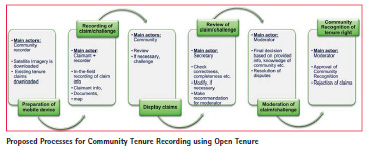
Suggested Community Processes for Open Tenure
The following processes are a starting point for a discussion with communities envisaging community recording of tenure relationships potentially using SOLA Open Tenure and SOLA Community Server software. Such a discussion would be by way of informing the community of possible processes they could utilize and in the interests of the community receiving ‘free, prior and informed consent’ (FAO, 2014) before making the commitment to undertake community recording.
These suggested processes begin with initial discussions with the particular community as a whole so that they are well informed on what community tenure recording is (and is not) and the activities that will accompany it.
Members of the community with specific roles such as community recorder, member of the moderation committee and the committee’s secretary / Open Tenure administrator are identified and trained in those roles.
Once those preparations are complete tenure recording can begin. In the Cambodia Open Tenure field test in addition to recording ownership tenure rights of rice fields and dwellings, certain areas with community forestry characteristics will also be recorded including areas such as ‘Spirit Forest’, ‘Wetlands’ and ‘Illegal logging areas’. Before the start of field recording, Community Recorders identify the areas they will be working in over the next day or two and download existing tenure rights data and high resolution satellite imagery from the SOLA Community Server onto their Open Tenure tablets. With these downloads the Community Recorders are able to operate off-line while in the field.
In the field, Community Recorders, using Open Tenure, collect details on the property itself (such as name or identifier and land use), ownership (including multiple owners and defined shares), images of supporting documents, photos of owners and the property and a map of the property. Community Recorders are encouraged to map the property in terms of the satellite imagery but the builtin GPS in the tablet can also be used to confirm the property’s location, confirm the geo-referencing of the imagery or define the position of a property corner.
Once field capture of property details is complete and the Community Recorder returns to their base, they are then able to upload the recently captured property details to the SOLA Community Server. Once uploaded the property details are viewable by other members of the community through the web-based Community Server as well as hardcopy maps and listing of all uploaded properties at the pagoda near the Community Recorder’s base. If there is a challenge to any of the uploaded property claims, the challenger arranges for a counter claim to be prepared using Open Tenure or directly through the SOLA Community Server. Any such challenge includes all the same details from the original claim to property ownership plus a link to the original claim.
The period of time that a property claim needs to be displayed before it is finalized needs to be decided by each community. In this ‘Display Period’ the original claimant may upload additional supporting documents, if necessary. Once the agreed upon display time is over, dispute resolution processes will be initiated in the case of any challenges. With un-challenged claims, the secretary to the community moderation committee will use SOLA Community Server to check that there are no missing details and, if there are, request the claimant to provide those details. Once the secretary is satisfied that claims are adequately described and dispute processes are complete, they will organize a meeting of the community moderation committee. At that meeting the moderation committee will confirm, modify or reject property claims and these change in status will be reflected on the SOLA Community Server.
In the longer term, changes in ownership will be reflected on the SOLA Community Server in a similar fashion either using details collected on mobile devices running Open Tenure or directly through the SOLA Community Server.
It should be noted that all these described processes need to be discussed and agreed to by the community at the time of initial engagement and could very well be modified to reflect the specific concerns of each community. Each community will decide on the processes associated with Open Tenure tenure relationship recording and not a law and associated regulations and rules such as would happen in formal land administration. Likewise access to Open Tenure captured data will be decided by the community bearing in mind the interests of self governance of the communities resources. The rather sad history in many parts of the world of external parties exploiting the resources of local communities at the expense of local communities is likely to work against the adoption of open data concepts such as are being promoted in the developed world.
This is not to say that a formally defined process might not be devised in the future that would bring these Open Tenure defined and community moderated properties within the formal land administration system. Technically this is simple. However such a move is one for the community to propose and then for those responsible for formal land administration to define an appropriate legal and administrative mechanism for this to happen.
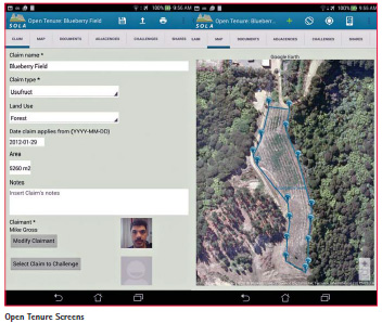
Open Tenure Software Operation
Open Tenure allows community based recorders using Android based tablets or Apple iPads to record claims to tenure rights. Details captured with Open Tenure include a description of the tenure right, identification of the owners, images of supporting documents and photos and the boundaries of the tenure right in terms of fit-for- purpose map imagery augmented by GPS positions. Once captured these details are stored on an Open Tenure Community (cloud based) Server where they can be viewed by other community members and challenged if there is a dispute. The Open Tenure Community Server also supports processes that lead to community recognition of the recorded tenure rights.
Future Open Tenure Development
There are a number of issues arising that are likely to influence the further development of Open Tenure.
Existing users of other SOLA applications have expressed an interest in using Open Tenure in systematic registration and in field inspection work by State land managers and valuers. There is also interest in using Open Tenure for citizen recording of boundary disputes and reserve encroachments. These uses of Open Tenure would require modifications to the main SOLA software to copy uploaded Open Tenure captured details into the relevant tables within the main SOLA database tables in addition to the usual configuration of Open Tenure as occurs when it is used for the first time with a new community.
It is expected other forms of Community Server will be established in the near future by other agencies wishing to encourage community level recording of tenure relationships. These may result in changes to how data is structured and transferred between Open Tenure and the Community Server. Likewise, these new community servers may become a source of recent, high resolution, low cost aerial or satellite imagery for download and offline use in Open Tenure and this may necessitate changes to the way imagery is downloaded to Open Tenure.
Another challenge is that although there appear to be Google Android mobile devices in the places where community tenure recording would be beneficial, these devices are primarily smaller smart phones. On smaller screens Open Tenure could be difficult to use, particularly the mapping functionality and a simplified version of Open Tenure may need to be developed.
Future directions for SOLA software
The full potential of open source software application on mobile devices to address tenure related needs has a long way to go before it has been fully explored. Astute land administration practitioners in as diverse countries as Nigeria, Vietnam and Afghanistan have seen or heard of Open Tenure and despite its initial focus on community recording of tenure relationships have quickly seen its potential for use in a range of land administration field activities. Another positive and interesting possibility would be extending Open Tenure to facilitate greater citizen participation in tenure administration and even leading to a new model for delivering land administration services beyond the current web service based e-government model.
These possibilities deserve attention. Not only are they technically exciting but they would advance the implementation of the VGGT significantly.
References
Bradley, Amanda, 2014. ‘Concept Note – Piloting of Open Tenure with the Monks’ Community Forest in Cambodia’. NRC Land Tenure FAO, Rome.
Food and Agriculture Organization of the United Nations, 2012. ‘Voluntary Guidelines on the Responsible Governance of Tenure of Land, Forests and Fisheries’. Retrieved from http:// www.fao.org/docrep/016/i2801e/i2801e. pdf, (Last accessed 29 January 2015).
Food and Agriculture Organization of the United Nations, 2014. ‘Respecting free, prior and informed consent – Practical guidance for governments, companies’. Retrieved from http://www. fao.org/docrep/019/i3496e/i3496e.pdf, (Last accessed 27 January 2015).
McDowell, Andrew, 2011. ‘Software Architecture Document for the SOLA Development Snapshot’. Retrieved from http://www.flossola. org/sites/default/files/sola_software_ architecture_document_v1.1_0.pdf, (Last accessed 29 January 2015).
Mortimer, Robert, 2014. ‘SOLA Open Tenure Application Layout Report’, NRC Land Tenure FAO, Rome. Pullar, Neil; McDowell, Andrew; Solovov, Alexander; Manoku, Elton; Rizzo, Maria Paola, 2012. ‘Solutions forOpen Land Administration (SOLA) Software – Customising Open Source Software to Support Land Administration Services and Responsible Land Governance’, Paper presented at World Bank Land & Poverty Conference.
Pullar, Neil, 2013. ‘The FAO SOLA Open Source Software Pilots – A Step Towards Transparent and Responsible Governance of Tenure’. Paper presented at World Bank Land & Poverty Conference.
Toma, Antonio, 2014. ‘Open Tenure Mobile Data Crowdsourcing for Open Land Administration’. Retrieved from http://www.flossola.org/sites/default/files/ open_tenure_mobile_data_crowdsourcing. pdf , (Last accessed 29 January 2015).
The paper was presented at the “2015 World Bank Conference on Land and Poverty” The World Bank – Washington DC, March 23-27, 2015


 (60 votes, average: 1.48 out of 5)


Leave your response!