| Surveying | |
The Northern Territory – Digital survey and cadastral innovators
The processes identified in this paper can relate to any jurisdiction in the world that is looking to digitally manage and upgrade cadastral data |
 |
|
The Northern Territory (NT) has been able to introduce innovative digital survey and cadastral management for Land Administration. GNSS became the obvious alternative to historical traversing in remote areas and the NT recognised early that a survey accurate coordinated digital database was the way of the future.
Since the mid 1990s the NT used applications that stored the original survey plan measurements to create objects (lots/parcels) that could be joined together and adjusted to build a survey database that would be the cadastral layer in developing GIS for land administration. The process adheres to rules of topology and connectivity to ensure the veracity of the digital process.
The survey accurate database SPICAD created from survey plans and coordinated survey control is incrementally replacing the Digitised Cadastral DataBase (DCDB) as the authoritative cadastral database. SPICAD is now used to spatially analyse new surveys and then that new survey data is used in spatial upgrading a local area of SPICAD.
From the beginning local surveyors were engaged by the project for back capture of plans and the survey of control for the co-ordination of land parcels. This inclusion process engendered ownership and allowed a smoother implementation of other technical and administrative changes. Importantly, they came to understand that this was a different approach to managing their survey data, and it set the agenda for their role and responsibilities in digitising the cadastre.
In July 2016, DIPL (NT Government, Department of Infrastructure, Planning and Logistics – Land Information Group) mandated all survey plan lodgements to be completely digital but with a mixture of digital images, a file of machine readable content of certain parts of the plan for a degree of automation and an examination report generated by the surveyor.
The NT also has the capacity for land boundaries to be delimited or defined by coordinates through Legislation enacted in 2004. The Surveyor-General has discretion to declare these areas when they are satisfied that the SPICAD model is of suitable precision to represent the surveyed boundaries or a property is suitably defined by SPICAD. Three (3) “pilot” areas have been declared to date.
Unit (strata) Plans and their 3D components are now being captured in SPICAD.
This Paper follows the digitisation processes and outcomes from the beginning to recent times.
Introduction
The Northern Territory (NT) covers over 1.3 million sq. kms and is sparsely populated with approximately 250,000 people mainly in several urban areas with approximately 85,000 land parcels. Pastoral Leases can cover large expanses and in the past these boundaries (up to 80km) were traversed by survey parties but now GNSS surveys can do in 1 day what may have taken weeks or months in the past.
In the mid-1990s the NT Government were engaging with the implementation of the Association of Consulting Surveyors (ACS) survey coordinate geometry software developed by Michael Elfick and Mike Fletcher. Development work on the GeoCadastre survey database application by Elfick and Fletcher had been under way for several years. DIPL recognised the benefits of GNSS and a digital survey database over 20 years ago and looked at how to take advantage of these new technologies.
The varied expertise and background experience of Elfick and Fletcher generate a powerful synergy in moving from a manual hard copy land administration system to a digital one. Dr Michael Elfick is a Registered Surveyor in New South Wales with experience in private industry, as a senior technical advisor to the NSW Lands Department & a University academic in surveying. Mike Fletcher is a software engineering systems developer with considerable experience in large corporate digital systems.
Michael and Mike began development of a ‘survey coordinate geometry package’ for PDP-11 systems for ACS in the early 1980’s, which was then adapted for PC’s in 1990. Development of the Parcel Fabric Survey Database Application GeoCadastre began in 1990 in conjunction with the Hunter Water Board (Utility) in NSW and then with the Northern Territory since the late 1990’s.
This was the beginning of the NT becoming survey and cadastral innovators with the guidance and applications of Elfick and Fletcher that use survey processes to manage survey data in a GIS object based environment.
Elfick and Fletcher continued development of the process for generating coordinate based cadastral systems from measurement based “Metes and Bounds” information with projects in NSW, Queensland, the Philippines, New Zealand and the USA. From 2004 Michael and Mike worked with the ESRI development team to incorporate the GeoCadastre cadastral management engine into the ESRI GIS environment. This was licensed to ESRI as the Parcel Editor tool in the ESRI Enterprise system used by all level of Government and Utilities worldwide. ESRI adopted the GeoCadastre (GC) structured text file for the management of cadastral boundary information in the Cadastral Editor XML (CEXML) interchange format. It was important to maintain the survey integrity of the process in that GIS environment even though the level of rigour in data verification and analysis was not usual GIS practice.
GeoCadastre provides a local survey solution to fit survey plans together into a seamless database for ongoing upgrading with survey and spatial data. That process and data structure is scalable into the ESRI Parcel Fabric GeoDatabase to manage a dynamic strategic or State Land Administration system. For the Northern Territory Elfick and Fletcher developed an application to store the cadastral data in a standard SQL database or other suitable databases and can be accessed via web applications.
In spite of the NT being a statistically small jurisdiction with limited budgets, it showed initiative to progress digitisation at a time when others were unsure how to progress.
The geocadastre parcel fabric – A digital survey database solution
In the Torrens Title System, government maintains a register of land titles with a comprehensive record of ownership and the “RRRs” – Restrictions, Rights and Responsibilities (FIG, 2005) related to that land. That register includes a spatial representation generally supplied by a survey plan of a deemed standard that is referenced by the title register.
In the Torrens System, Government generally provides a guarantee of title (indefeasibility) but does not guarantee the exact dimensions or spatial extents based on the fact that older survey plan dimensions may vary slightly from the accurate distance between monuments. Spatially it is based on the premise of “monument over measurement” which dictates any monument or survey mark placed by the original surveyor determines the location of a boundary, irrespective of any measurements on a survey plan defining a Title.
GeoCadastre is based on the process that Licensed/Registered Surveyors would follow in their computations using the field measurements and notations shown on survey plans that legally represent the spatial extents of land titles in Torrens or similar survey plan based systems.
In a desktop database solution, plan parcels were joined together in a seamless parcel fabric survey database and then a Least Squares Adjustment (LSA) would use survey intuition to get the most accurate outcome based on the information available. This survey database exists in a coordinated database where Fletcher’s system management expertise provided considerable value.
Any point in a digital database is defined by coordinates and any object in a mapping database is defined by a collection of points. Survey plans only define the relationship between points and adjoining objects so there has never been a wider location context until the advent of the database. The GeoCadastre Parcel Fabric connects those two sets of data.
The Elfick/Fletcher process looks to the survey plan as a means to feed the available survey measurements into the database and then uses tools to validate the quality of that data and adjusts it to the most informed location. Michael Elfick comments “In a measurement based title system it is important to view coordinates as simply being derived information, not the base reference material itself”.
Working with survey dimensions as attributes of all parcels increases the capacity to manage and analyse cadastral data by using a Least Squares Adjustment (LSA). Adjoining parcels defined by surveys from different eras can share the same node points and provide redundancies to the LSA. This provides a more rigorous adjustment outcome than a coordinate based solution as well as a tool to analyse a dataset for errors in data entry or recorded on survey plans.
The GeoCadastre text file holds the measurement and other database intelligence. This format was adopted early and the NT has retained that transfer structure even though other States have adopted the Australia wide Intergovernmental Committee on Survey and Mapping (ICSM) LandXML ePlan standard structure. The ICSM LandXML file structure is limited to one ‘survey’ or plan, whereas the GeoCadastre text file can represent one or many plans in an adjusted survey database. The GC file also has some extra cadastral functionality that includes ‘Line Points’ that allow a line of many segments to remain a straight line in the adjustment as indicated by the survey plan. See Diagram 1 below.
Implementing digitisation in the Northern Territory
The NT began by looking for a better way to manage the pastoral lease areas, but it realised that the GeoCadastre process was applicable to the whole territory. The problem was approached from a survey point of view – that is to honour the data and capture the survey information from the plans and hold it in a logical way.
The design of the system unfolded by simply following what actually existed. That is, plans contain parcels, parcels are made up from lines, lines have a point at each end, some points coincide with a control point; and each object (Plan, Parcel, line, point and control point) has a number of data types. For example a point has X, Y, Z etc.
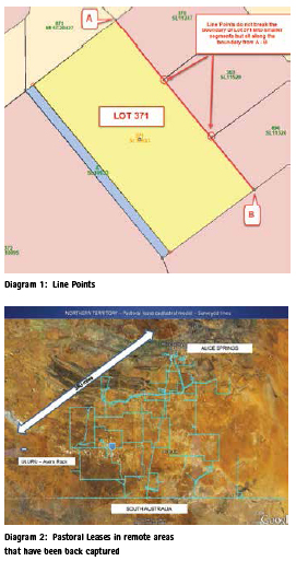
Larger Pastoral Leases were initially defined by (curved) parallels of latitude but traverses undertaken to mark the extents of these leases on the ground (up to 60 years ago) were a series of straight lines between the pegs placed. Under the auspices of Torrens Title the pegs/monuments placed by those surveys now defined the boundary. That allowed the boundary survey traverses to be back captured and create the survey database. (See Diagram 2)
From the 1990s the NT manually entered and stored the original survey plan measurements to create objects (lots/parcels) that could be joined together and adjusted to build a survey database that would generate the cadastral layer in developing GIS for land administration. The process adhered to the rules of topology and connectivity to ensure the veracity of the digital process.
The back-capture was undertaken by in-house survey staff and outsourced locally. Local surveyors were also engaged by the project for survey coordination of control points.
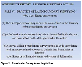
An early outcome of the implementation was recognition that coordinates could be used as prima facie evidence to determine the location of a boundary. Legislation enacted in 2004 was not complicated so the Surveyor-General could determine suitability of areas without needing to consider excessive conditions in the Legislation. (See Diagram 3) This recognised the future capacity of GNSS and the survey database (SPICAD) to accurately define land under the Torrens System.
The Surveyor-General has discretion to declare these areas when they are satisfied that the SPICAD model is of suitable precision to represent the surveyed boundaries or a property is suitably defined by SPICAD. Three (3) “pilot” areas have been declared to date .As of July 2016, DIPL has mandated all survey plan lodgements to be completely digital but with a mixture of formats that is each “Fit- For-Purpose”. Whilst the “Fit-For-Purpose Land Administration” publication (Enemark FIG, 2014) was focussed on developing countries, a flexible and pragmatic approach is equally applicable to developed countries.
The process requires surveyors to lodge:
1. a digital image of their new survey plan as they have prepared it in the past
2. a GeoCadastre text file of specific content. That content relates to parcel dimensions and other measurements that can benefit the spatial upgrading of SPICAD and statutory jurisdictional content needed for transactions.
3. a Northern Territory Plan Examination Report generated by GeoCadastre verifying the text file data content.
4. New geodetic data in various digital formats including:
▪ Location diagrams
▪ Observation data
▪ Coordinate listing
▪ Other relevant reports
The NT digital cadastral content may be reduced but retains all data relative to a rigorous solution. However it is scalable if more rigour or cadastral intelligence is required in the future.
After the plan and data is Registered and new titles are issued, the GC text file is used for updating the cadastral survey database. A ’packet’ of the parcels surrounding the new title is extracted from SPICAD as a joined survey database. The new GC text file including survey control coordinates is joined to the packet and adjusted. This spatially upgrades the packet database but the outer extents are held fixed to return seamlessly to SPICAD. The subdivided parcel remains in the survey database with an ’historical’ parcel designation. Historical parcels are not visible as part of a current cadastre but are always accessible.
As the original survey measurements are stored in SPICAD, this survey database packet can be used for spatial examination in GeoCadastre. Comparisons of new survey measurements and existing survey measurements can be made or there are strategic options to compare new and old spatial database locations with relative precision reporting.
Surveys completed since 1980 are of the highest precision and are generally spatially enabled so the capacity exists to move to greater digital processes with SPICAD underpinning the processes supported by the Coordinated Survey Areas Legislation outlined above.
The current status
The Department of Infrastructure, Lands and Planning (DIPL) has all but completed the back capture of survey plans into SPICAD which facilitates dynamic 2D digital cadastral modelling. The process to replace the Digitised Cadastral DataBase (DCDB) mapping database with the survey database created from survey plans and coordinated survey control is under way.
Comments from the Director Survey, DIPL (Rob Sarib) on the current status note that: the Department has seen efficiency gains (less red tape) in the processing of survey plans and the subsequent issue of a title, and also greater transparency with respect to the roles and functions of surveyors in the public / private sector.
It has also been an integral part of the pathway in the electronic (digital) land development cycle – that is from an application to develop a parcel to the issuing of tenure. For the NT it has been an incremental process to fully digitise the cadastral information cycle; although it has taken some years, rapid technological and system developments in the geospatial and survey arena has provided more flexible and Fit-For-Purpose options.
The challenges that remain include:
▪ Surveyors having the appropriate skillsets / capabilities for the future
▪ Legal, policy and institutional hurdles – land survey statutory requirements, standards & practices, guidelines with respect to – what is the legal medium / form defining the cadastre, digitising, rendering information, auditing etc
▪ Technical :
▪ back capture and digitisation of survey data (units and other interests – “RRRs”)
▪ reviewing and updating the cadastral information model for 3d / 4d and a modernised digital cadastral system
▪ visualisation of the cadastre
▪ upgrading to a survey accurate spatial cadastre (cm)
▪ Unification of jurisdictions on matters associated with Cadastre 2034 – national approaches versus local
▪ Completing the replacement of the DCDB geometry with SPICAD geometry
The development of the NT cadastral system has been driven by surveyors over the last 100 years. Now land administration and management has to make sure that all legal and other entities are correctly represented in the database. Many existing mapping polygons must be reworked as they differ from survey data and the complexity lies in the detail.
One historical issue being dealt with by DIPL is that spatial management of land (the survey plan) and the tenure (ownership details) is managed by different departments and each has a unique identifier (UI). These need to be linked by another unique identifier (the LAISKEY). By comparison some other states use a UI defined by a Lot/Plan configuration which identifies both the survey and legal entities.
A further challenge is representing land tenure or an interest (RRR) which is located within OR is over the parent parcel that has another form of tenure or interest. The tenure status of this parcel of land is sometimes referred as “secondary tenure” or an “admin parcel” as it is NOT excised from the parent or underlying parcel. This land tenure could also be registered or NOT registered with the Land Titles Office.
In the short term, the greatest benefit will be for DIPL, but it will benefit private sector surveyors as they start to understand the counter intuitive object based process and the value of the data available. Where they intend to do a cadastral survey they can download an area of the survey database that would have all available survey plans joined together and adjusted to available coordinated control. It will be in a machine readable text file, so it will be readily accessible to new applications in the future and it would be the most accurate representation of the real world cadastre. This is one of the major objectives of DIPL in the future electronic land development cycle.
The model coordinates would assist the surveyor in quickly finding monuments or survey marks relative to their survey objective. That would either confirm the spatial integrity of the existing database or where boundaries differ, they can be presented as an updated digital file and rendered diagram to DIPL from their working dataset.
Converse to that is the capacity of the survey database to assist surveyors in finding problems in the field or on survey plans. Where things don’t fit in the field the surveyor can use variations of GNSS control in the adjustment to identify quickly where the problem or problems in the existing survey data may be.
Local surveyors are aware of the initiatives of DIPL but as they are being implemented in the immediate future they are still learning some of the detail of the processes and how they will benefit them in their field work, their computations and digital outcomes. DIPL will facilitate that knowledge transfer.
3D cadastre in the Northern Territory
3D cadastre in Australia is mostly spatially defined by the regulations of Strata Title Acts in each state. The Strata Title Legislation that allows people to own the freehold title of an apartment was first enacted in NSW in 1961 and the basic Regulations have not changed significantly since that time. Across Australia there are in the order of 300,000 Strata schemes housing over 3 million people.
Strata plans have limited measurement or height data as the ownership extents are defined by the faces (or centres) of structural walls or columns and the upper and lower levels (or centres) of structural floors. Measurements were not required as an owner or others could immediately determine exactly the extent of ownership. Structural components of buildings and shared access areas are deemed Common Property and are managed by a representative group of unit owners. Services supplying water, sewer, electricity, drainage etc were deemed to be covered by Rights, Restrictions or Responsibilities, irrespective of the fact that their location may be uncertain.
The Strata Title Legislation could be deemed Fit-For-Purpose as it is a basic but elegant solution for a complex ownership arrangement but spatial data from existing strata plans to populate 3D digital databases is not readily available. BIM modelling is quoted as the future source of good digital data but BIM data is not available for existing Strata Plans or the majority of 3D cadastral entities currently being constructed or into the near future.
In the NT, capture of basic components for 3D cadastre visualisation is now considered in the plan registration process and those 3D attributes are stored in the survey database for future 3D modelling. DIPL will determine the structure of the intelligent digital data supplied by the surveyor at the time of Strata Plan registration. This data collection and management will allow the automation of 3D modelling.
The flexibility of the GC text file allows extra attribute fields to be incorporated so the digital data supplied by the surveyor contains the required 2D and 3D intelligence. That 3D intelligence can nominate every individual unit as an object in the database so units on top of each other will be co-linear but 3D modelling applications will provide the visualisation capacity.
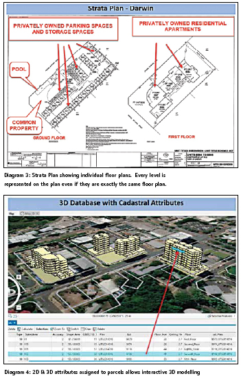
The real challenge to all States is integrating the 300,000 Strata Schemes that have no 3D spatial attribution into the digital environment. See Diagram 3.
The digitisation process is not difficult for existing Strata plans if the spatial precision requirements are not set too high and the economics of a Fit-For-Purpose outcome are adopted. Diagram 4 below shows the capacity of the ESRI ArcGIS Pro application for dynamic 3D modelling with basic 2D and 3D attributes provided. If the data is accessible any similar visualisation application can be utilised.
The future
The foundation of the future NT cadastral database will still be built on the information captured from the original survey plans but smarter applications will be able to enhance the outcomes and that smarter data will be able to be utilised by other applications.
The current capacity to capture parcel 3D attributes will flow through to capturing parcel 4D attributes that will feed the dynamic land administration foundation that will be responsive to higher precision and accessibility.
Surveyors are uncertain how Torrens Title land can be defined by a coordinated database in the same way it has been done since 1863. In the edict ‘monument over measurement’ coordinates become the new monuments as they define a specific point on the ground. If the surveyor is satisfied that he or she can prove that a coordinate does not accurately represent the original corner, they can put their evidence to the Titles Office and if the evidence is accepted then the coordinates of that point in the database can be amended to a more accurate representation. This follows the same process in the existing system where the surveyor would register a plan of redefinition as the spatial reference for a title if they disagree with the current spatial representation shown on a plan.
This highlights how critical the 4th dimension attributes are in the system for the future as any surveyor would be required to check that any boundary survey they are undertaking reflects the current coordinates of the title. This also considers any geodetic adjustments that improve the spatial quality of the coordinates or datum shifts like the Geocentric Datum of Australia (GDA) 2020 shift of approximately 1.8m in Australia to match the continental plate drift with GNSS datum.
Concluding remarks
The processes identified in this paper can relate to any jurisdiction in the world that is looking to digitally manage and upgrade cadastral data. The NT cadastre is measurement based (bearing and distances) but the processes implemented by the NT are equally applicable to a coordinate based cadastre.
The strength of the NT processes are that all types of spatial data (survey traverses, GNSS, imagery location, crowd sourcing, etc) can be used for location upgrading with the spatial integrity of the data taken into consideration to give greater security of title into the future. With the applications available, states should be rapidly looking at digitisation implementations to capture and retain the integrity of good data moving forward while considering how historical legal records are brought into the system.
NT took a leap of faith in the 1990s in the digitisation implementation. With limited finances and resources the NT did not begin the process by going down the classic path of completing business strategies and setting up complex Data Models, etc. With the guidance of Elfick and Fletcher the Northern Territory considered what survey plan data was most relevant to the digital environment and began development and implementation.
The NT is now benefitting from that foundation as the 4th Industrial Revolution introduces technological infrastructure for automation of processes and transactions. In their own way the NT are survey and cadastral innovators as they manage the transition from the measurement based title system of the past to a position based title system of the future (Elfick 2010).
Acknowledgements
Dr Michael Elfick – Wallalong, NSW, Australia
Robert Sarib – Director Survey, Northern Territory Government, Department of Infrastructure, Planning and Logistics – Land Information Group
Daniel Reimers – Surveyor, Northern Territory Government, Department of Infrastructure, Planning and Logistics – Land Information Group
Keith Schulz – Director – Earl James and Associates – Surveyors, Darwin, Northern Territory
Robert Monteath – Registered Surveyor / Licensed Strata and Community Manager, Newcastle, NSW.
The paper was presented at 15th South East Asian Survey Congress (SEASC2019) Darwin, Australia, 15-18 August 2019.


 (26 votes, average: 2.46 out of 5)


Leave your response!