
Articles in the Articles Category



After his extended sick leave Everest reached India …
Dr Manmohan Singh, Prime Minister of India has recently expressed concern over the ‘decline …

“Create synergy between the science and application of …

“No one can hold back the power of nature. But globally …

To carry out the infrastructural development in any area, topographical maps (accurate, reliable and updated) of that area are of vital important. Topographic maps are also important aids for administrative and strategic planning, disaster mitigation, socioeconomic development and other related activities. In order to prepare topographic map, it is prerequisite to have grid coordinates as well as elevations of control points.

Says Flemming Lindholm, Regional Sales Manager-Europe, Asia …

Says Michael Lindsay, Chief Operating Officer, NavCom Technology …
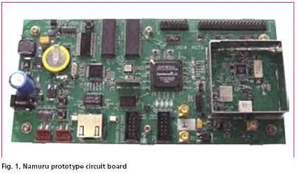
Development of a Field Programmable Gate Array (FPGA) based GNSS receiver platform has been underway at the University of New South Wales (UNSW) ‘SNAP’ lab since 2004. The receiver now has a name; ‘Namuru’ that means ‘to see the way’ in the language of the Eora people who inhabited an area around Sydney, including the UNSW campus, before the arrival of the British. The receiver was introduced in the Coordinates January 2006 edition and in this article we first provide a brief recap and then look at the latest developments and results from testing. But before launching into this, the question of why such a research and development platform is desirable must be answered.




