| GNSS | |
Advances in GPS/GNSS data processing
|
|||||||||||||||
|
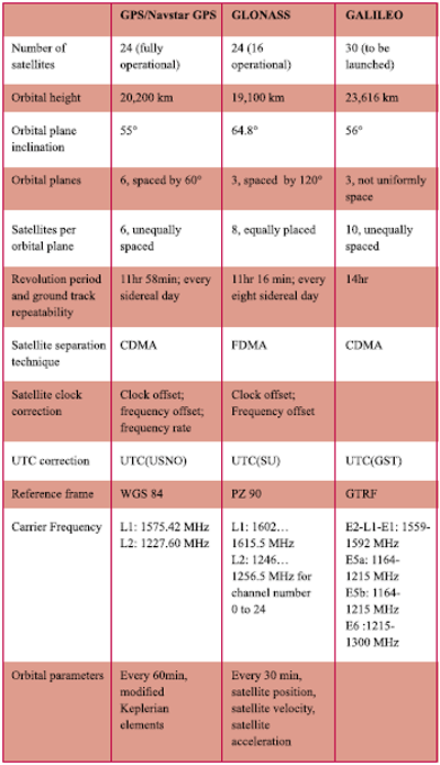
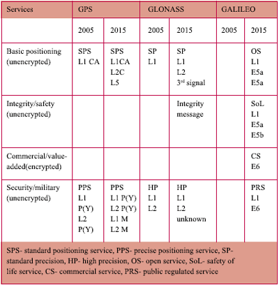
GNSS is a global navigation satellite system comprising of network of satellites that transmit ranging signals used for positioning and navigation anywhere around the globe; on land, in the air or at sea. The US Global Positioning System (GPS/Navstar GPS), the Russian Global Navigation Satellite System (GLONASS) and the upcoming European GALILEO system, Data communications satellites with navigation payloads and Augmentation systems are all part of GNSS. IGS the offi cial website of voluntary federation of more than 200 worldwide agencies that pool resources and permanent GPS station data to generate precise products formerly known as International GPS service has now been renamed as International GNSS service. The conventional GPS data processing techniques are also being modified to incorporate the new satellite systems of GNSS which pose major challenges of different satellite signals, different reference frames and different time scales to be incorporated for combined processing. Most of the academic and commercial existing data processing softwares process the code and phase pseudo ranges obtained from L1 and L2 satellite signals of Navstar GPS / GPS to obtain the positions. Most of the world wide users are currently dependent on Navstar GPS technology which is owned, operated and controlled entirely by one country, the United States. Bernese 4.2 GPS software has the capability to process the satellite signals of both Navstar and Glonass GPS systems and combining them to give the precise and improved positions. Proposed Navstar GPS modernisation has thrown new challenges with two new satellite civil signals L2C, and L5 which will be available for initial operational capability by 2010 and for full operational capability by approximately 2013. The current NAVSTAR GPS data processing software’s now should be able to absorb these new civil signals for positioning. The world wide GNSS network of tracking systems now recognises the demand for real time processing of 1 Hz GNSS data for early warning and rapid damage assessment. Potential user groups who would benefi t from the availability of GNSS data and products include from among others; geodetic agencies mandated to provide access to a globally consistent reference frame for all position applications, precision navigation users (LEO), agencies involved in natural hazards monitoring, prediction, warning and response, structural engineering monitoring, near/real-time atmospheric monitoring for weather prediction, real-time earthquake seismology (simultaneously with seismological analysis), and time transfer and dissemination. The IGS Real-time Working Group (RTWG) is presently assessing and addressing issues that pertain to the IGS developing realtime infrastructure and processes.. GNSS data processingCurrently, there are only two satellite navigation systems in operation, the Global Positioning System (GPS/ Navstar GPS), and the Russian equivalent GLONASS system. Galileo satellite navigation system due to be launched by European Union in 2006, will be made available to public by 2010. Table 1 gives the comparison of present and future Global navigation satellite systems and Table 2 gives the present and future services of GNSS. In addition to the these main GNSS infrastructures, Quasi-Zenith Satellite System of Japan is under development (QZSS), with three satellites placed in a special orbit that maximizes coverage over Japan and Beidou satellite navigation and positioning system of china consisting of two geosynchronous satellites to complement the existing GNSS systems. Space Based Augmentation Systems (SBAS) and Ground-Based Augmentation Systems (GBAS) have been built (or are being deployed) by the United States, Europe, India, Japan, Australia and China to augment the existing GNSS. Currently majority of GPS users worldwide are using only GPS/ Navstar GPS for their application and the major scientifi c GPS data processing software only process the data form Navstar satellites. Only exception to this is the BERNESE 4.2 software which has the capability to combine the GPS and GLONASS satellite data. The success story of BERNESE group of being able to combine the two different satellite navigation systems with different satellite signals, reference frames and time scales gives confi dence for the inclusion of Galileo and future satellite systems. GNSS data processing will now become a cost-effective and precise approach of high-accuracy software simulations which are reproducible and totally controlled by the user, and parameters can be changed individually if necessary for an in-depth analysis of the combing the various GNSS systems. The immediate need of the GPS community is to be able to include the new satellite signals L2C and L5 of Navstar GPS in to the data processing software’s as it effects majority of the GPS users worldwide. Table 1: Main features of GNSSReal time GNSS data processingMany very demanding applications and systems now require GPS raw data and products in real time with greatly reduced delays which underlines a need for the availability of real time data and products required for the real time GNSS data processing. The GPS Earth Observation Network System (GEONET) in Japan consisting of 1200 GPS stations with an average spacing of about 20 km has been successful in real-time observations and analysis. For real time analysis GPS sites should sample data at 1 Hz and transmit the measurements in real time to the analysis center which are then processed for instantaneous coordinates and baseline components which are then adjusted with absolute ITRF coordinates of the stations suffi ciently remote from the region of analysis. Instantaneous coordinate accuracy is about 1-2 cm in the horizontal and 10-20 cm in the vertical, compared to the known ITRF coordinates of the stations. Real time instantaneous (horizontal) position changes detected by a dense GPS network (like GEONET) could be used as part of an early warning system for mitigating natural hazards. To fully serve the multi-disciplinary scientifi c user community the IGS real-time working group (RTWG) is working towards enhancing its standards for infrastructure, data and product availability. The primary products of such a system will be GPS/GNSS station data, satellite orbits and clocks, made available to the user by Internet and other economical and available streaming technologies. This will also ensure a standardization of the real time networks and would cater to multiple user community as non-IGS near/real time networks are emerging without standards. Real time water vapor estimation (SuomiNet and GeoNET) is already been integrated in to Weather Research and Forecasting (WRF) model which is a new generation advanced mesoscale (10km-1km) model for both operational numerical weather prediction (NWP). Improved rainfall forecast due to assimilation of GPS Precipitable Water Vapor were observed for several hours into the forecast. Similarly, Ionospheric perturbations associated with atmospheric disturbances, such as earthquakes, large explosions, or rocket launches have been detected through fi ltering of dual- frequency real time GPS phase data. Table 2 Current and future services of GNSSIt is important to track the ionosphere which is a dynamic region capable of adversely impacting a variety of space-based systems. FutureRecent advances highlight the huge potential that exists for future navigation and positioning applications. The vast majority of the world will be users of these existing systems which pose a whole lot of questions like: Which system or systems should a country use? Which combination of systems? What are the benefi ts and respective merits of those systems? What kind of integration should be followed? What kind of real time GNSS network should be used? Which data processing software to use? Etc… There is no simple answer to these questions, as the best solution will undoubtedly depend on the application, which has its own requirements in terms of accuracy, reliability, robustness, cost, and other application-specifi c criteria. What can be provided, however, is a means whereby parameters that describe these performance requirements can be computed. Software needs to be developed to conduct a qualitative assessment of the performance characteristics of future GNSS infrastructure. From now till the year 2015 there will be a constant and radical change in the existing GNSS data processing techniques though the underlying principles will not change much. As a user , one needs to keep abreast with all the latest developments in this fi eld as the current processing software’s will be adopting to the new satellite signals, new satellite systems , different reference frames and real time availability of the data and the products Referenceshttp://igscb.jpl.nasa.gov/ http://www.comp.glam.ac.uk/ http://topex.ucsd.edu/SAR/ http://www.gnss2004.org/ http://www.agu.org/meetings/fm04/ http://europa.eu.int/comm/dgs/energy_ U.Hugentobler, S.Schaer and P.Fridez, Heinz Habrich and G.Beutler, Geodetic Applications of the GLONASS and of GLONASS/ GPS combination. Günter W. Hein, Jeremy Gödel, Jean-Luc Issuer, Jean-Christopher Martin, Philippe Erhard, Rafael Lucas-Rodriguez and Tony Pratt, Status of Galileo frequency and system design, Members of the Galileo Signal Task Force of the European Commission, Brussels Jan skaloud and Patrick Viret , GPS/INS Integration, European Journal of Navigation, Vol 2, 2004 C.Seynat, a Performance Analysis of Future Global Navigation Satellite Systems, the 2004 International Symposium on GNSS/GPS. |
|||||||||||||||
|
|||||||||||||||
|


 (No Ratings Yet)


