Articles in the Mapping Category


Digital images collected form airborne or space-borne sensors often contain systematic and non-systematic geometric errors that arises from the earth curvature, platform motion, relief displacement, nonlinearities in scanning motion, the earth rotation, etc . [1]. The intent of geometric correction is to compensate for the distortions introduced by these factors so that the correct image will have the highest practical geometric integrity.

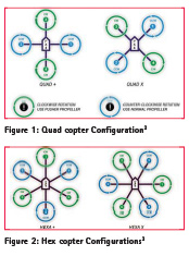
UAVs/drones can be simply defined as robotics planes. It is also known as Unmanned Aerial Vehicles (UAV), unmanned aircraft systems (UAS) and remotely piloted aircraft (RPAs) Ivosevic et.al. (2015). Malaysia Department of Civil Aviation (2008)…

The construction of infrastructure requires land on which the infrastructure is planned. If the constructor does not have any formal rights to that land, land use conversion needs to takes place such that the land can be legally acquired by the construction…

India is at an infrastructure crossroads. As demand for infrastructure development has grown, the country’s tireless growth has raced ahead of its ability to develop and deliver the necessary number infrastructure projects…
Balloons can be regarded as the oldest platform for aerial observations. As early as in 1858, Tournachon aboard a hotair balloon…

Unmanned Aerial Vehicle (UAV) System has gained popularity in the field of photogrammetry, remote sensing and geospatial engineering for civilian applications…

Water gates in the Isahaya bay were closed because of reclamation construction which started in 1989, and water conversion became a very serious problem. Then, the authors have carried out remote sensing research with a few centimeters…

Information has generally been one of the most precious goods in recent decades. It is possible to buy and sell it, to barter it or just only freely provide it. The value of the information itself is very often based on the fact that it is…

Drones are defined as flying robots in simple terms which are formally known as Unmanned Aerial Vehicles (UAV). The main distinctive characteristic of drones is the design to be operated with no onboard pilot. They are operated by remote controller or can fly autonomously through software controlled flight plans….

The three authors of this paper work at the Applied Geodetic Division of the National Laboratory for Civil Engineering (LNEC), in Lisbon, Portugal. LNEC is a state owned research and development institution founded in 1946…


 (5.00 out of 5)