


The new IMO Sub Committee on Navigation, Communications Search & Rescue considers the Strategy Implementation Plan for e-Navigation at its meeting in July 2014 (NCSR1). The e-Navigation solutions embodied in that Plan depend on reliable, robust positioning…

Climate change has been one of the main causes of the rise and fall of civilisations, migration and destruction of complex societies from the apocalyptic story of Noah’s Ark and the flood, through the ice age to the present time. The development of complex societies and population…

The Federal Territory of Putrajaya (Putrajaya) is the administrative capital of the Malaysian Federal Government with an area of 4931 hectare. It is divided into 20 precincts and consists of 10,580 land parcels…
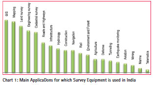
When one is very close to a thing it becomes blurred and to see it in focus one has to step back. To get a focus on the Survey and Measuring Equipment (S&ME) Industry in India…

The successful development of receivers, application technologies and services is a key requirement for the commercial success of the European Satellite Navigation System Galileo.

The demand for recognizing the user position is steadily increasing not only in the outdoor but also in the indoor. In the outdoor, the global navigation satellite system (GNSS) is available and guarantees high levels of positioning accuracy..

UAVs (Unmanned Aerial Vehicles), or as most civil aviation authorities now call them, UASs (for Unmanned Aircraft Systems), are attracting a lot of attention lately from geospatial professionals…

March 28, 2014, World Bank, Washington DC
This one-day ‘Spatial Innovation and Good Practices’ forum was jointly convened by the World Bank and the International Federation of Surveyors (FIG) on March 28, 2014 at the World Bank’s headquarters in Washington DC as part of the ongoing collaborative activities between the Bank and FIG. The Forum was …


 (5.00 out of 5)