| Surveying | |
Implementing multipurpose cadastre in Malaysia
As part of the Department of Survey and Mapping Malaysia (JUPEM) continuous effort to further modernize the cadastral system in Peninsular Malaysia, a pilot project on multipurpose cadastre (MPC) for the Federal Territory of Putrajaya (Putrajaya) has been carried out. |
 |
|
|
 |
|
The Federal Territory of Putrajaya (Putrajaya) is the administrative capital of the Malaysian Federal Government with an area of 4931 hectare. It is divided into 20 precincts and consists of 10,580 land parcels. The Department of Survey and Mapping Malaysia (JUPEM) is a government agency responsible for the geodetic, topographical, mapping and cadastral surveys in Malaysia. JUPEM is also responsible for the demarcation and survey of the state and international boundaries.
The cadastral survey in Malaysia is based on the cadastral coordinated system. Steps have been taken to enhance the National Digital Cadastral Database (NDCDB) for Peninsular Malaysia (including Putrajaya) and Labuan with survey accurate coordinate system.
In the bid to understand the complexity and structure of a Multipurpose Cadastre (MPC) concept in Malaysia, a MPC pilot project has been conducted in Putrajaya.
Multipurpose cadastre (MPC)
The modern cadastral system is made up of the cadastral map and associated registers. Both of these entities represent the graphical and textual component of the cadastral system.With the modern cadastral system continually evolving to meet the demand of the land market, other land information databases containing information such as planning control and the land-value assessment are being progressively added onto the modern cadastral system. This modern cadastral system is a step towards the Multipurpose Cadastre concept. The Multipurpose Cadastre is an extension of the modern cadastre to include other land information registers.
The multipurpose cadastre concept was described as ‘a framework that supports continuous, readily available and comprehensive land-related information at the parcel level.’ The concept is expected to benefit all levels of governments and society. Increased sharing of datasets, public transactions of data and reduction of administrative costs are a few of the benefits foreseen.
A multipurpose cadastre is designed to record, store, and provides not only land records information but also a wide variety of parcel-object related information using large scale base map. It is truly multipurpose since it not only receives information and data from many sources, but it also provides relatable services and products for many purposes and to many users.
MPC pilot study for Putrajaya
The scope of work for the MPC pilot project for Putrajaya is as follows:
– Development of an updated Local Geospatial Data Centre (LGDC) dataset with new large scale geospatial dataset and integrating it with the NDCDB;
– Data acquisition using MTLS system for generating 3D point cloud of Putrajaya and extraction of building footprints and other related geospatial features;
– Data fusion comprising high resolution satellite image, LiDAR and terrestrial point cloud data to generate 3D city model and 3D Spatial Data Infrastructure (SDI) for Putrajaya;
– Development of MPC Application Module; – Integration with street addresses database for Putrajaya;
– Development of Ubiquitous Multipurpose Cadastre Systemincorporating Service Oriented Architecture (SOA); and
– Development of Online Web Access Putrajaya MPC Database which consist of LGDC, building footprints, street addresses, high resolution satellite image and 3D city model.
For the MPC pilot project, the enhanced National Digital Cadastral Database (NDCDB) which is referenced to the Geocentric Datum of Malaysia2000 (GDM2000) through a dense Cadastral Control Infrastructure (CCI) serves as the fundamental reference layer. Consequently, the 2D Local Geospatial Data Centre (LGDC) dataset for Putrajaya was updated and referenced to the NDCDB. The other core data layer that has been developed for MPC Putrajaya is the 3D city model using 3D point-cloud data acquired through Mobile Terrestrial Laser Scanning (MTLS) technology. As such, the MPC system that has incorporated ‘survey accurate NDCDB’ and ‘survey accurate 3D geospatial data acquisition technology’ can be called a ‘survey accurate MPC’.
Project implementation approach
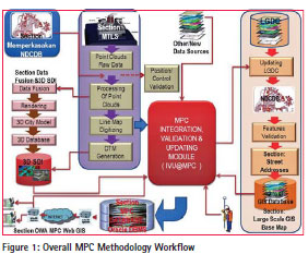
Figure 1 shows the implemented workflow for MPC Methodology being carried out in the MPC Putrajaya project. The JUPEM NDCDB enhancement project that is being concurrently implemented provides large scale cadastral layer over Putrajaya. Additional geospatial features data collection has been carried out using Mobile Terrestrial Laser Scanning (MTLS) technology. The output of MTLS is a 3D point clouds represent coordinate (x,y) and elevation (height). 3D point clouds from MTLS produces geospatial information such as 3D-city model and DTM for Putrajaya. Combination of these two 3D datasets produce the 3D SDI database. A module for Integration, Validation and Updating of MPC datasets has been developed for the integration, validation and updating purposes of various large scale geospatial basemaps. 3D MPC Online Web Access has been developed using ArcGIS Server platform accessed via ArcGIS Explorer Desktop that provides service oriented architecture (SOA) functionality. 3D MPC Online Web Access provides access to the 3D SDI datasets and possible SOA services.
2D existing geospatial data acquisition
Using the existing data, the 2D Local Geospatial Data Centre (LGDC) for Putrajaya has been updated with primary purpose of creating theme layers for all large scale geospatial basemaps in Putrajaya. Primary sources of the available datasets were extracted from the existing database available at JUPEM and Malaysian Centre for Geospatial Data Infrastructure (MaCGDI): GLMS layers, large scale mapping data, digital elevation model, high resolution satellite image, airborne LiDAR data, orthophoto, utility data, street addresses, textual data, MyGeoid data, MyRTKnet station coordinates, levelling benchmark values and cadastral control infrastructure coordinates.
Furthermore, the State Geospatial Data Centre (SGDC) dataset available at MaCGDI for Putrajaya area has also been acquired to be integrated with the LGDC data. The SGDC data consists of various data categories such as Built Environment, Transportation, Demarcation, Topography, Vegetation, Hypsography, Hydrography and Utility.
3D MTLS point cloud data acquisition
MTLS is an emerging technology that combines the use of a laser scanner(s), the global navigation satellite systems (GNSS), and an inertial measurement unit (IMU) on a mobile platform to produce accurate and precise geospatial data. The data is initially adjusted by post-processed kinematic GNSS procedures from separate GNSS base stations placed throughout the project area. The GNSS solution is then combined with the IMU information to produce geospatial data in the form of point cloud. This point cloud is then adjusted by a local transformation to well defined points throughout the project area to produce the final geospatial values. Point clouds have been produced in GDM2000 coordinate system and vertical reference being reduced to Mean Sea Level (MSL) and National Geodetic Vertical Datum (NGVD).
Additional 3D geospatial features for Putrajaya has been carried out using Mobile Terrestrial Laser Scanning (MTLS) technology. The MTLS scanner (DynaScan system) (http://www.mdl. co.uk) which has been used for data collection includes scanners, GNSS units, IMU, processing software and all equipments complied with the specified specifications. The accuracy of DynaScan MTLS system at 95% confidence level (1��) are as follows: horizontal accuracy: ±5cm and vertical accuracy: ±7cm.
The output of MTLSafter processing is 3D point clouds that represent Geocentric Cassini coordinate (N,E) and elevation above sea level (H). 3D point clouds from MTLS produces geospatial information that comprise of building footprint, road, utility (lamp post, fire hydrant, electrical post and else), lake, tree and other features captured in the scanning window. The
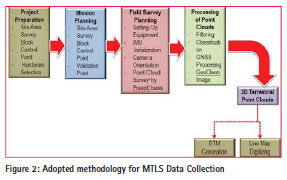
adopted methdology for MPC MTLS data collection is shown in Figure 2. The methodology comprises five main phases of activities as follows: Project Preparation, Mission Planning, Field Survey Planning, Processing of Point Clouds and Digitization from processed 3D Point Clouds.
Geodetic Datum Transformation System (MTRANS) Version 4.1 software has been used to transform all the point clouds to GDM2000 datum reference system and projected to Cassini (GDM2000) coordinates. Vertical reference system was based on National Geodetic Vertical Datum (NGVD) by reducing the ellipsoidal height to Mean Sea Level (MSL) height using MyGeoid and local levelling bench marks (Figure 3).
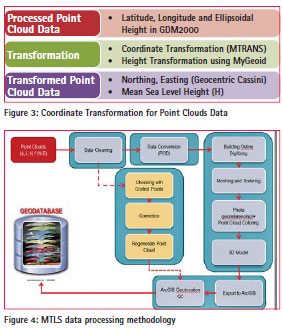
The top part of buildings in Putrajaya was not able to be scanned by MTLS survey. Hence, additional data provided by LiDAR and high resolution satellite images have been utilized to fill-up the gaps (roof top images). Detail on the adopted processing methodology for the collected MPC MTLS data is shown in Figure 4.
MPC application module
MPC Data Integration, Validation and Updating Module has been developed based on a desktop-based GIS development environment to extend GIS functionality, customize and automate repetitive operations, and integrate ArcGIS version 10 with VBA functionality.
Integration with street addresses database
Street addressing is to assign an address using a system of maps and signs that give the numbers or names of streets and buildings. Geocoding of Street Address database was based on the enhanced NDCDB and building feature acquired during data acqusition process. Enhanced NDCDB consists of cadastral lot information, Unique Parcel Identifier (UPI) and newly created object identification (OID). OID was also created for building feature. Based on the street address database, geocoding process can be conducted systematically using cadastral lot number, UPI and OID. These information can be linked to zip or postal method to generate street address based on integrated MPC GIS base map.
Generating 3D city model
Present geospatial data acquisition technology coupled with the advances in geographical information system (GIS) and computer technologies enable the creation of 3D landscape models. 3D city models are the most widely created and used landscape models. They consist of Digital Elevation Models (DEM) of ground surface overlaid with structure and texture of buildings. Such models may be created at five levels of detail (LoD).
– LoD0: a DEM with superimposed ortho-rectified aerial or satellite imagery.
– LoD1: basic block-shaped depictions of buildings are placed over LoD0.
– LoD2: LoD2 adds to LoD1 detailed roof shapes.
– LoD3: represent further expansion by adding to LoD2 structural elements of greater detail, such as facades and pillars, and draping all objects with photo texture.
– LoD4: the highest level, is achieved when the building can be virtually visited and viewed from the inside.
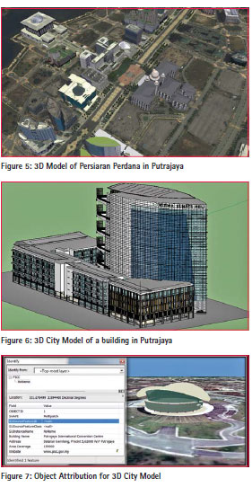
For this pilot project, Level of Details 2 (LoD2) has been used to depict 3D building in the housing estates in Putrajaya. Buildings in Precinct 14, Putrajaya, for example were digitized in this manner. Level of Detail 3 (LoD3) has been used to depict main government buildings along the Main Boulevard in Putrajaya, while LoD4 has been developed for the Putrajaya Central.
3D Model for Putrajaya has been digitized manually using Google Sketchup and exported to ArcGIS Map (Figure 5). This was then integrated to the database in ArcGIS Server. This project could be recalled via a client PC through ArcGIS Explorer Desktop.
3D City model visualization for Putrajaya integrates image textures for rendering process. This process generates virtual reality of the real world. Sketchup and ArcGIS Desktop Explorer software has been used to drape the related image to 3D city model as shown in Figure 6.
The 3D City model was generated from the MTLS and GIS Base Map data categories. Attribute entry has been carried out based on the available information obtained from the MTLS scanning. Data fusion from multiple geospatial datasets contains attributes information enriched the 3D city model for Putrajaya (Figure 7). LoD 3 is used for the Main Boulevard. Residential area in Precinct 14 is used as a pilot area for LoD 2 digitizing and overlaid with the current NDCDB.
PUTRAJAYA MPC database
The MPC Database development is the core for the whole pilot project. It consists of the following main characteristics:
– NDCDB as a base map;
– Local Geospatial Data Centre data;
– Geographic Information
– Feature and Attribute Codes (MS1759);
– Malaysian Metadata Standard (MMS);
– National Geonames Database;
– Unique Parcel Identifier (UPI) and Administrative Code;
– Colour Code and Symbol;
– 3D City Modeling for Putrajaya; and
– 3D Spatial Data Infrastructure for Putrajaya.
The accuracy of 3D MTLS features in the MPC Database for Putrajaya has been found to be better than 15cm for horizontal coordinates while the accuracy of the vertical coordinate is twice the accuracy of the horizontal coordinate. This accuracy can be further improved with the use of a more sophisticated MTLS system.
PUTRAJAYA MPC online web access
3D MPC Online Web Access has been developed using ArcGIS Server platfrom accessed via ArcGIS Explorer Desktop or ArcGlobe that can provide service oriented architecture (SOA) functionality. 3D MPC Online Web Access can provide access to the 3D SDI datasets and possible SOA services.
The main security window has both login for JUPEM staff and public access. The public will have limited access to the database. JUPEM login will have full login to database. For public users who wish full access to the database can apply to JUPEM directly for a full access username and password.
For 3D viewing, MPC ArcGIS Desktop Explorer is used. All viewing of 3D Models will be through the software intended for public users. Users are required to have access to the MPC Server to be able to view the 3D models. JUPEM users who have access to ArcGlobe are also able to view the 3D models, but JUPEM users also need access to the MPC Server.
Ubiquitous and Service Oriented Architecture (SOA)
Ubiquitous means the ability to have or seeming to have the ability to be anywhere at anytime. MPC-OWA means mechanism or system that could integrate all related information for a land parcel in order to provide maximum accessibility in term of location, time and method of access. User can access MPC information using various devices such as personal computer, handheld terminals and smart telephone that is connected to an online system.
Benefits of MPC
The benefits resulting from the development and use of a MPC system has been recognised for some time. The MPC system that has been developed for Putrajaya incorporate some of the recent most advances in computer and GIS technologies as well as the latest MTLS 3D geospatial data acquisition technology. The MPC system that has been developed certainly will revolutionise the way large scale geospatial data is utilised in this country.
Applications of MPC include utility mapping, land administration, urban and regional planning, land valuation, flood mapping, GIS for local authorities, emergency response services, crime GIS, environmental management and coastal management.
Findings and recommendations of the pilot project
The findings and recommendations of the MPC pilot project in the Federal Territory of Putrajaya are as follows:
– Existing geospatial data in the State Geospatial Data Centre (SGDC) and Local Geospatial Data Centre (LGDC) need to be geo-referenced with respect to the NDCDB. The SGDC and LGDC need to be current and complete.
– Survey grade MTLS system should be employed in 3D point cloud data acquisition to ensure higher level of accuracy and resolution of the acquired 3D features.
– There is an urgent need to develop a program for the production of large scale base map at scale 1:500 to 1:1,000 in urban areas and densely populated, 1:5,000 to 1:10,000 in semi-urban areas, while for rural and remote areas at scale 1:25,000.
– The scope of cadastral survey should be enhanced to collect large scale geographic information such as building footprint, drain, fire-hydrant, access road, etc., and the features are to be updated into MPC Database.
– The MPC Database needs to be continuously maintained in order to ensure acceptable spatial accuracy, temporal accuracy, thematic accuracy, completeness, consistency, and resolution.
– MPC Database should be integrated with the NDCDB and high-rise building database for data updating purposes. On the other hand, SOA concept should be used for updating information from other databases such as mapping databases, underground utility database and other databases from other agencies. – Priority should be given for the implementation of MPC in major cities in Peninsular Malaysia and Labuan in phases, followed by MPC implementation for semi-urban and rural areas with reduced resolution.
– Future marine geospatial and cadastral infrastructure should be incorporated in the MPC Database.
– Public assessment and feedback should be sought from other government agencies, private sector and the public to assess the relevancy of the MPC Database.
Conclusion
The MPC Pilot Project for the Federal Territory of Putrajaya has enabled JUPEM to understand the complexity in the implementation of the MPC for Malaysia. It is hoped that the findings and recommendations based on the pilot project will enable the successful gradual implementation of the MPC for the whole country. This will surely enhance the concept of spatially enabled government and society in Malaysia and fulfilling the nation’s vision.
References
Department of Survey and Mapping Malaysia – Final Report on MPC Pilot Project for Federal Territory of Putrajaya, January 2013.
Department of Survey and Mapping Malaysia – Final Report on the Enhancement of National Cadastral Database for Peninsular Malaysia and Labuan, November 2012.
The paper was presented at FIG Working Week, Ambuja, Nigeria, 6 – 10 May 2013.


 (11 votes, average: 3.73 out of 5)


Leave your response!