

Human population continues to accumulate in urban centers. This inevitably increases the urban footprint with significant consequences for biodiversity, climate, and environmental resources. Urban growth prediction models have been extensively studied…

State Space Agency of Ukraine (SSAU) ensures Space Policy on the following directions: creation of launch vehicles and spacecraft launches; remote sensing, including creation of space observation systems; satellite navigation using GNSS; space monitoring and analysis; seismic and geophysical monitoring, including monitoring of nuclear test ban treaty; space science and exploration.

Digital images collected form airborne or space-borne sensors often contain systematic and non-systematic geometric errors that arises from the earth curvature, platform motion, relief displacement, nonlinearities in scanning motion, the earth rotation, etc . [1]. The intent of geometric correction is to compensate for the distortions introduced by these factors so that the correct image will have the highest practical geometric integrity.

One of the oldest studies in geophysical sciences is geomagnetism – the study of Earth’s magnetic field, also referred to as the geomagnetic field. The phenomena associated with the geomagnetic field have been researched and monitored for centuries by many countries…

Volume XIII, Issue 06, June 2017
Zip
Mobile Mapping System in Reconstruction and Expansion of Highway in India
Rick Ma
An eye on magnetic field anomalies along the roads
Matej Bažec, Aleksander Grm, Franc Dimc
EGNOS multimodal performance
Pedro Pintor, Roberto Roldán, Manuel Lopez- Martinez, Alina Hriscu
Instruments of land
mobilisation – concepts and examples
Walter Timo de Vries
The Evolution …
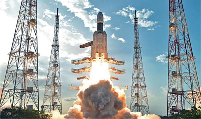
A Giant leap
Last month, it was GSAT-9,
South Asia Satellite.
And now a giant leap
With the successful developmental flight of
India’s heaviest Geosynchronous Satellite Launch Vehicle,
the GSLV Mark-III,
Indian Space Research Organization (ISRO)
Has placed India with the elite few
Who have excelled in cryogenic technology.
The successfully placing
Of a satellite weighing …
June 2017
37th EARSeL Symposium
27-30 June
Prague, Czech Republic
http://symposium.earsel.org/37thsymposium-Prague/
July 2017
IGS 2017: International GNSS Service Workshop
3 – 7 July Paris, France
http://www.igs.org
IEEE Frequency Control Symposium and European Frequency and Time Forum
9 – 13 July Besançon, France
http://www.eftf-ifcs2017.org
Esri User Conference
10 – 14 July San Diego, USA
http://www.esri.com/events/user-conference/papers
Geo4Africa Summit 2017 Conference
11 – 14 July Kampala, Uganda
http://geo4africa.com
United Nations/United States of America Workshop on the …
Icaros releases Version 5.0 of OneButton™
Icaros Inc. has released version 5.0 of OneButton™ Standard and Professional image processing software for UAVs. It has been developed for geospatial end users to easily and automatically generate precise, fully orthorectified 2D maps and 3D models from frame-based aerial imaging systems. Originally engineered for manned aircraft sensors, the …
Leica Ready now offered on Liebherr dozers, excavators
Leica Ready machine control kits will now be offered on dozers and excavators by Liebherr, one of the world’s largest manufacturers of construction machinery. Working with high precision GNSS, Leica Ready kits bring increased accuracy and improve efficiency up to 30 per cent. Enabling swift and fast …
STMicroelectronics and Allystar partnership
STMicroelectronics is working with Allystar to develop and market GNSS solutions for automotive products and other applications. Allystar is a spin-off from CEC Huada Electronic Design Co. Ltd. and a Chinese GNSS chip designer. ST and Allystar are already co-marketing products for the automotive market and cost-competitive products for the consumer …


 (5.00 out of 5)