
Articles in the Articles Category

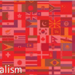
As the Covid-19 virus keep surging again and again,
The world rushes to get vaccinated.
And some saw and see opportunities in many ways,
There are many, who contributed to the crisis,
There are few who rival for credits and occupying market share.
Hence, my vaccine is better than yours!
Though the debate is understandable …

As Christopher Alexander conceived and defined through his life’s work – The Nature of Order – wholeness is a recursive structure that recurs in space and matter and is reflected in human minds and cognition. Based on the definition of wholeness, a mathematical model of wholeness, together with its topological representation…

European Railway Traffic Management System (ERTMS) is the European standard for the Automatic Train Protection (ATP) and command and control systems. ERTMS is a safety system enforcing compliance from trains with speed restrictions and signalling status….
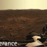
Another feat of human perseverance
When the Mars 2020 Perseverance Rover
Landed on the surface of Mars on Feb 18,2021
To look for habitability, seek biosignatures, cashing samples and
test oxygen production from the Martian atmosphere.
Equipped with new entry, descent, and landing (EDL) technologies, such as Terrain-Relative Navigation (TRN),
That allows the rover to …
Free Resources to Protect Critical Infrastructure From GPS Spoofing
The Department of Homeland Security (DHS) Science and Technology Directorate (S&T) has published the Positioning, Navigation, and Timing (PNT) Integrity Library and Epsilon Algorithm Suite to protect against Global Navigation Satellite System (GNSS) spoofing, or deceiving a Global Positioning System (GPS) device through false signals. These …

James van Rens
Strategic Advisor RIEGL Group / Government & Industry Relations.
In the present challenging times, how has RIEGL adapted itself and have also come out with technology solutions for its customers especially ‘operating remotely’?
RIEGL is committed to ensure our customers’ needs are met. While our company as a whole has adapted to what is now …

At the Moscow University of Geodesy and Cartography the training course “C++ for cartographers and surveyors” is used to educate students. The C++ programming course focuses on the use of cartographic tasks and geodetic exercises to illustrate various programming language constructions. A computer training program to be used as…

Medici Land Governance (MLG) captures property information including spatial and textual data by identifying and mapping land boundaries using high resolution drone imagery. MLG works closely with country governments to establish formal property ownership for land owners by implementing Systematic Land…

On December 2020, the Italian Public Administration requested the governance of a project aiming in the creation of the digital infrastructure needed to support the anti-Covid-19 vaccination. Among the most important objectives of the project was the real time, multistakeholder accountability, with both push and pull information…
‘What is readily available globally does not need to be regulated’,
So says, the ‘Guidelines for acquiring and producing Geospatial Data and Geospatial Data Services including Maps’ released by the Government of India on Feb 15, 2021.
This has been said many times for the last so many years,
By many who relentlessly kept advocating and demanding
To unleash …


 (5.00 out of 5)