| Application - New | |
AUSPOS and CORSnet-NSW: A match made in heaven
This paper outlines how AUSPOS and CORSnet-NSW are used to support datum modernisation in New South Wales (NSW), Australia, and investigates the performance of AUSPOS across the State |
 |
|
 |
|
AUSPOS is Geoscience Australia’s free online Global Positioning System (GPS) processing service (Jia et al., 2014; GA, 2020a). It has successfully processed more than 1 million jobs worldwide over the last 10 years and was ranked highest in a global comparison of free online post-processing tools (Gakstatter and Silver, 2013).
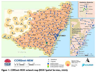
CORSnet-NSW is Australia’s largest state-owned and operated Continuously Operating Reference Station (CORS) network (Janssen et al., 2016; NSW Spatial Services, 2020). It is built, owned and operated by Spatial Services, a unit of the NSW Department of Customer Service (DCS). CORSnet-NSW currently consists of 202 stations, providing fundamental positioning infrastructure that is authoritative, accurate, reliable and easy-to-use for a wide range of applications. Since May 2019, it delivers all-in-view, all-signals, multi-constellation Global Navigation Satellite System (GNSS) data, making it the nation’s first CORS network to reach this milestone.
This paper outlines how AUSPOS and CORSnet-NSW are used together to support datum modernisation and improve state survey infrastructure across New South Wales (NSW). We quantify AUSPOS performance across NSW, demonstrating that it routinely delivers Positional Uncertainty (PU) at the 0.02-0.03 m level for horizontal position and 0.05-0.06 m for ellipsoidal height. We also show that AUSPOS provides a much better connection to the Australian HeightDatum (AHD, see Roelse et al., 1971) than reported. These results reveal that AUSPOS is a very suitable, efficient and reliable option to establish, propagate and strengthen the NSW Survey Control Network.
AUSPOS
AUSPOS accepts static, 30-second Receiver Independent Exchange (RINEX) data of at least 1 hour duration (recommended minimum 2 hours, maximum 7 consecutive days). The user’s antenna type is selected from a drop-down menu, and the height of instrument (measured vertically to the Antenna Reference Point, ARP) is entered. The best available International GNSS Service (IGS) station data and products (IGS, 2020) and the Bernese software version 5.2 (Dach et al., 2015) are employed to compute precise 3D coordinates, using GPS data only. Up to 15 surrounding IGS and Asia-Pacific Reference Frame (APREF, see GA, 2020b) stations are selected as reference stations, generally the 7 closest IGS sites and the 8 closest APREF sites.
Usually after a few minutes, a processing report (pdf) is emailed to the user. This includes coordinates in the two most recent Australian datums (GDA2020 and GDA94, see ICSM, 2020a) and the global ITRF2014 (Altamimi et al., 2016), as well as a physical (normal-orthometric) AHD height for Australian data. The report also provides the computed coordinate uncertainties, ambiguity resolution statistics, and an overview of the GPS processing strategy applied. For advanced users, Solution Independent Exchange (SINEX) files containing more detailed information are available for download.
AUSPOS and CORSnet-NSW
All CORSnet-NSW stations are part of APREF and contribute to the AUSPOS service, including 13 concretepillared NSW sites incorporated into the IGS network (Figure 1). This provides a relatively dense network in NSW for generating a reliable regional ionospheric delay model and tropospheric delay corrections to support ambiguity resolution. A precise solution is then computed using double-differencing techniques.
During AUSPOS processing, IGS station coordinates are constrained with uncertainties of 1 mm for horizontal position and 2 mm for ellipsoidal height. Lower-tier CORS coordinates are constrained with uncertainties of 3 mm for horizontal position and 6 mm for the vertical, due to the shorter CORS operation time span, lower data quality or lower-grade monumentation. The GPS data is processed in the IGS realisation of ITRF2014 and then transformed to GDA2020 via the Australian Plate Motion Model. Derived AHD heights are computed by applying a gravimetric-geometric quasigeoid model (AUSGeoid2020, see Brown et al., 2018; Janssen and Watson, 2018; Featherstone et al., 2019) to the GDA2020 ellipsoidal heights. Legacy GDA94 coordinates are obtained from GDA2020 by transformation.
Positional Uncertainty (PU) is defined as the uncertainty of the horizontal and/ or vertical coordinates of a point, at the 95% confidence level, with respect to the defined reference frame (datum) (ICSM, 2014). A description of the practical implementation of PU on public record in NSW can be found in Janssen et al. (2019). The coordinate uncertainties of East, North and ellipsoidal height reported by AUSPOS are scaled using an empirically derived model, which is a function of duration, data quality and geographical location, and expressed at the 95% confidence level (Jia et al., 2016).
Supporting datum modernisation
Datum modernisation and further improvement of survey infrastructure is required to accommodate the increasing accuracy and improved spatial and temporal resolution available from modern positioning technologies to an ever-broadening user base. NSW Spatial Services employs AUSPOS as one of several suitable methods to maintain and extend the State’s Survey Control Network. To this end, AUSPOS data of at least 6 hours duration is used to propagate the datum in NSW, while AUSPOS data of less than 6 hours duration strengthens the datum. This distinction is made based on the higher quality of AUSPOS solutions exceeding 6 hours duration and their eligibility for inclusion in the National GNSS Campaign Archive (NGCA) hosted by Geoscience Australia.
NSW Spatial Services is currently building an updated ‘passive’ Survey Control Network (in the Eastern and Central Divisions) with a minimum of one fundamental survey mark observed by 6+ hour AUSPOS every 10 km. Its vision is to ensure that any future user is no further than 5 km (and often much less) from such a fundamental mark providing direct connection to datum. Similarly, levelled AHD marks are observed by 6+ hour AUSPOS every 10 km, often at a far greater density. This will allow users to achieve NSW Spatial Services’ vision of a PU of 20 mm in the horizontal and 50 mm in the vertical (ellipsoidal height) component anywhere in the State and easily apply transformation tools to move between current, future and various historical datums and local working surfaces.
The use of AUSPOS campaigns has developed into a capable and reliable alternative to conducting traditional static GNSS baseline surveys, simplifying logistics by removing the requirement of field crews having to occupy particular survey marks at a set time. As a consequence, processing, adjustment and report writing efforts have been significantly reduced or removed. AUSPOS also forms a new and fundamental component of vertical datum modernisation and the propagation of the Australian Vertical Working Surface (AVWS, see ICSM, 2020b).
At present, the GDA2020 state adjustment incorporates approximately 31,000 survey control marks across NSW, i.e. 12% of the 250,000 marks on public record. Consequently, 88% of the marks have been transformed from GDA94 to GDA2020.
Uncertainties of these transformed GDA2020 coordinates are given null values until these are calculated via inclusion in the state adjustment. As shown in this paper, AUSPOS is a suitable method to accelerate the process of including additional survey marks into the state adjustment in order to improve user access to GDA2020 coordinates and uncertainties.
Data and methodology
We used 2,618 GNSS datasets observed by NSW Spatial Services over the last 5 years (November 2014 to August 2019). Data was collected under typical conditions generally encountered in the field, with observation session lengths ranging from 2 to 48 hours. Each dataset was processed individually with AUSPOS version 2.3, using final IGS products.
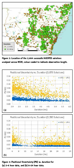
Some AUSPOS solutions were rejected for this analysis due to warnings in the AUSPOS report, referring to poor ambiguity resolution and/or large uncertainties. Overall, 154 sessions (5.9%) were rejected, including 121 (10.1%) of the 2-6 hour sessions and 33 (2.3%) of the 6-48 hour sessions. Upon investigation of site photos and other metadata, this was generally attributed to ambitious attempts to observe survey marks in locations with substantial tree cover, resulting in poor sky view conditions. As expected, shorter observation sessions were more prone to be negatively affected by these unfavourable conditions. For all 2,464 successful AUSPOS solutions (Figure 2), descriptive statistics were used to evaluate the uncertainties of the resulting GDA2020 coordinates.
We performed three tests:
1. Analysing Horizontal PU (HPU) and Vertical PU (VPU) of the AUSPOS solutions for GDA2020 horizontal coordinates and GDA2020 ellipsoidal heights, respectively.
2. Analysing the repeatability of AUSPOS solutions for reoccupations on the same mark.
3. Analysing AHD results by comparing the AUSPOS-derived AHD height to levelled AHD heights on public record and investigating the AHD-PU reported by AUSPOS.
The results of two further tests can be immediately summarised:
• Whilst AUSPOS PU values are known to be affected (scaled) by latitude, the variation is negligible for user results within NSW.
• Whilst IGS products have continuously improved and CORS density has increased, AUSPOS version 2.3 performance has remained stable, predictable, repeatable and of high quality within NSW.
PU of AUSPOS solutions
First, we investigated the AUSPOS-derived HPU and VPU values. Descriptive statistics (i.e. minimum, maximum, range, median, mean and standard deviation) were examined for the entire dataset of 2,464 successful AUSPOS solutions (2-48 hour duration). To allow examination of the effect the observation session length has on the resulting uncertainties, we also investigated these descriptive statistics for the 2-6 hour and 6-24 hour subsets (Janssen and McElroy, 2020). Figure 3 presents a graphical visualisation of the results, showing PU as a function of observation session length for the 2-6 hour and 6-24 hour datasets.
As expected, a longer observation span generally improves PU. This is demonstrated by mean values of 0.023 m ± 0.006 m (1 sigma) for HPU and 0.069 m ± 0.022 m (1 sigma) for VPU when using 2-6 hour data, compared to values of 0.015 m ± 0.003 m (1 sigma) for HPU and 0.033 m ± 0.016 m (1 sigma) for VPU when using 6-24 hour data. Most of the improvement is gained by increasing the observation length from 2 hours to about 4-5 hours, with minor but not insignificant improvement when it is increased to 24 hours and beyond.
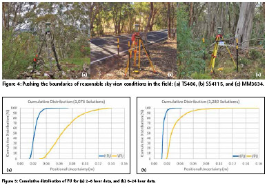
Observation sessions exceeding 12 hours provide AUSPOS solutions of substantially higher quality in the vertical component. An investigation of site photos and other metadata attributed the larger VPU values evident for solutions greater than 15 hours duration to poor sky view conditions caused by substantial tree cover. As an example, Figure 4 illustrates the conditions encountered at the sites producing the three largest VPU values. In spite of these poor conditions, AUSPOS solutions generally achieve acceptable HPU and heights with a VPU of better than 0.1 m.
Cumulative distribution
The cumulative distribution allows us to quantify the percentage of AUSPOS solutions meeting a particular PU threshold. Figure 5 visualises the cumulative distribution in regards to HPU and VPU for the 2-6 hour and 6-24 hour datasets, indicating the relationship between uncertainty and reliability achievable with AUSPOS. The reader can use these graphs as a simple ‘look-up’ tool to determine the likelihood of achieving any specified HPU or VPU threshold with 2-6 hour and 6+ hour observation sessions.
Across the entire dataset (2-48 hrs), 70.6% of AUSPOS solutions have HPU values of 0.02 m or better, i.e. these solutions have an absolute reported horizontal accuracy slightly larger than the size of an Australian 50c piece (radius of 16 mm) with respect to the national datum. This includes 38.6% of the 2-6 hour AUSPOS solutions and 95.2% of the 6-24 hour solutions with HPU values at this level. Similarly, 95.7% of all solutions have HPU values of 0.03 m or better, including 90.8% of the 2-6 hour solutions and 99.5% of the 6-24 hour solutions.
Regarding ellipsoidal height, 61.0% of the AUSPOS solutions have VPU values of 0.05 m or better across the entire dataset. This includes 23.3% of the 2-6 hour AUSPOS solutions and 89.7% of the 6-24 hour solutions with VPU values at this level. Similarly, 71.8% of all solutions have VPU values of 0.06 m or better, including 42.7% of the 2-6 hour solutions and 94.3% of the 6-24 hour solutions. These results are impressive, remembering that the uncertainties are stated at the 95% confidence level. As expected, a longer observation span improves PU, particularly in the vertical component. The findings illustrate why Geoscience Australia stipulates, and NSW supports, a minimum observation span of 6 hours for AUSPOS data to propagate the Survey Control Network in Australia.
Repeatability
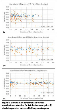
Repeatability was investigated by comparing independent reoccupations on the same mark. Where possible, independent pairs of sessions on the same mark were selected for three scenarios: two short sessions (2-6 hrs), one short (2-6 hrs) and one long session (6+ hrs), and two long sessions (6+ hrs). In each scenario, each session was only paired once. Since it is necessary to consider coordinate differences of opposite signs, the Root Mean Square (RMS) is appropriate to quantify the average agreement in the vertical component.
Figure 6 visualises the results, referring to the horizontal distance between the two AUSPOS solutions, as well as the difference in ellipsoidal height (shorter minus longer session). Again, it is evident that AUSPOS produces high-quality positioning results with good repeatability. While longer observation sessions improve the precision (repeatability) and reduce the risk of outliers (range), shorter sessions provide suitable results for strengthening the NSW Survey Control Network.
In July/August 2019, trigonometrical station TS3663 PANORAMA (located in Bathurst, close to NSW Spatial Services) was occupied 38(!) times, providing an opportunity to investigate the repeatability of AUSPOS solutions on this high-quality, concrete-pillared mark with excellent sky view. The longest observation session (48 hours) was assumed ground truth, with the AUSPOS results of the shorter sessions being compared against it (Figure 7). The average agreement is 0.006 m ± 0.003 m (1 sigma) in the horizontal component, and the RMS in ellipsoidal height is 0.010 m (1 sigma). This shows that observation sessions of less than 6 hours in length have high reliability and repeatability under good sky view conditions.
A bullseye plot of the difference in horizontal position from the 48-hour solution is shown in Figure 8, providing a spatial perspective and illustrating the high precision of these results.
AHD connection
For a subset of marks, we compared the derived AHD height determined by AUSPOS (using AUSGeoid2020) to levelled AHD heights of sufficient quality on public record, ensuring full independence from the data used to produce AUSGeoid2020. Figure 9 visualises the results for the 2-6 hour and 6-24 hour data, referring to the difference between the AUSPOS-derived AHD height and the levelled AHD height on public record. The AUSPOS solutions are consistent across all marks and observation durations, delivering AHD heights with an RMS of about 0.040 m (1 sigma) or 0.078 m (95% confidence level) and a range of about 0.35 m (-0.20 m to +0.15 m).
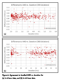
The derived AHD-PU reported by AUSPOS appears to be overly conservative for the data investigated, providing a mean AHD-PU of 0.182 m, which is more than double the RMS for the difference to the levelled AHD height at the 95% confidence level (i.e. about 0.078 m). This can be explained by the conservative AUSGeoid2020 uncertainty grid values applied, with the best-case official AUSGeoid2020 uncertainty in NSW being about 0.14 m at the 95% confidence level. It is pleasing to see that AUSPOS provides a much better connection to AHD across NSW than reported.
Conclusion
NSW Spatial Services, on behalf of the NSW Surveyor- General, has a legislative, regulative responsibility to maintain and extend the Survey Control Network in NSW. CORSnet-NSW sites comprise a fundamental, high-density and long-term component of AUSPOS infrastructure within the State. AUSPOS and CORSnet-NSW have proven to be an ideal match to establish, propagate and strengthen the NSW Survey Control Network.
In NSW, AUSPOS routinely delivers PU values of 0.02-0.03 m (horizontal) and 0.05-0.06 m (vertical). PU is substantially improved by increasing the observation length from 2 hours to 4-5 hours, and observation sessions exceeding 12 hours provide much higher quality in ellipsoidal height. AUSPOS results have a high degree of predictability and repeatability throughout the State at sites with good sky view, over at least the last 5 years. At sites with tree cover, acceptable HPU and ellipsoidal heights with a VPU of better than 0.1 m can be achieved. The derived AHD-PU values reported by AUSPOS appear to be overly conservative for the data investigated (0.18 m reported vs. 0.08 m presented here), due to the conservative AUSGeoid2020 uncertainty grid values applied by AUSPOS.
References
Altamimi Z, Rebischung P, Métivier L, Collilieux X (2016) ITRF2014: A new release of the International Terrestrial Reference Frame modelling nonlinear station motions, Journal of Geophysical Research: Solid Earth 121(8): 6109-6131.
Brown NJ, McCubbine JC, Featherstone WE, Gowans N, Woods A, Baran I (2018) AUSGeoid2020 combined gravimetric-geometric model: Locationspecific uncertainties and baseline-lengthdependent error decorrelation, Journal of Geodesy 92(12): 1439-1456 & 1467.
Dach R, Lutz S, Walser P, Fridez P (2015) Bernese GNSS software version 5.2, Astronomical Institute, University of Bern, Switzerland, http://www.bernese.unibe.ch/docs/ DOCU52.pdf (accessed June 2020).
Featherstone WE, McCubbine JC, Claessens SJ, Belton D, Brown NJ (2019) Using AUSGeoid2020 and its error grids in surveying computations, Journal of Spatial Science 64(3): 363-380.
GA (2020a) AUSPOS – Online GPS processing service, http://www.ga.gov.au/ scientific-topics/positioning-navigation/ geodesy/auspos (accessed June 2020).
GA (2020b) Asia-Pacific Reference Frame (APREF), https://www.ga.gov. au/scientific-topics/positioningnavigation/ geodesy/asia-pacificreference- frame (accessed June 2020).
Gakstatter E, Silver M (2013) A comparison of free GPS online postprocessing services, GPS World, https:// www.gpsworld.com/a-comparisonof- free-gps-online-post-processingservices/ (accessed June 2020).
ICSM (2014) Standard for the Australian survey control network (SP1), version 2.1, http://www.icsm. gov.au/publications/standard-australiansurvey- control-network-specialpublication- 1-sp1 (accessed June 2020).
ICSM (2020a) GDA2020 and GDA94 technical manuals, http://icsm.gov.au/ datum/gda2020-and-gda94-technicalmanuals (accessed June 2020).
ICSM (2020b) Australian Vertical Working Surface, https://www.icsm. gov.au/australian-vertical-workingsurface (accessed June 2020).
IGS (2020) IGS products, http://www. igs.org/products (accessed June 2020).
Janssen V, Gowans N, Hine S, McElroy S (2019) Removing the uncertainty surrounding Positional Uncertainty and Local Uncertainty in SCIMS, Azimuth 58(8): 28-32.
Janssen V, Haasdyk J, McElroy S (2016) CORSnet-NSW: A success story, Proceedings of Association of Public Authority Surveyors Conference (APAS2016), Leura, Australia, 4-6 April, 10-28.
Janssen V, McElroy S (2020) Assessment of AUSPOS performance in New South Wales, Australia, Proceedings of IGNSS Symposium 2020 (IGNSS2020), Sydney, Australia, 5-7 February, 17pp.
Janssen V, Watson T (2018) Performance evaluation of AUSGeoid2020 in NSW, Proceedings of IGNSS Symposium 2018 (IGNSS2018), Sydney, Australia, 7-9 February, 15pp.
Jia M, Dawson J, Moore M (2014) AUSPOS: Geoscience Australia’s on-line GPS positioning service, Proceedings of 27th International Technical Meeting of the Satellite Division of The Institute of Navigation (ION GNSS+ 2014), Tampa, Florida, 8-12 September, 315-320.
Jia M, Dawson J, Moore M (2016) Upgraded AUSPOS and refined solution uncertainty, presented at IGNSS Symposium 2016 (IGNSS2016), Sydney, Australia, 6-8 December.
NSW Spatial Services (2020) CORSnet-NSW, http://www.corsnet. com.au/ (accessed June 2020).
Roelse A, Granger HW, Graham JW (1971) The adjustment of the Australian levelling survey 1970-1971, Technical Report 12, Division of National Mapping, Canberra, Australia, 81pp.


 (No Ratings Yet)


Leave your response!