Articles in the Articles Category

SOME of the earliest known maps were made in Iraq which was drawn during 2400 BC for the purpose of land taxation. A Roman map dating 350 AD showed such topographical features as roads, cities, rivers and mountains. Although the basics of land surveying were known but the large scale maps before 16th century were limited to cities and other small areas. Up to the middle of 16th Century, there was little real knowledge of the geography of the most part of the world.

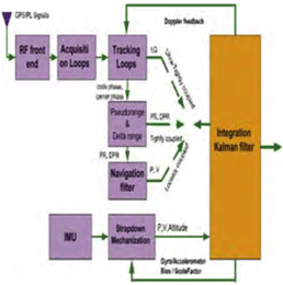
Inertial Navigation Systems (INS) are based on accelerometers and gyroscopes for position and attitude determination. Thus, INS is self-contained and autonomous. This makes INS an optimal option to be integrated with GPS, as both systems can complement each other to enhance positioning performance (Greenspan, 1996). On the one hand, the advantages of INS include high positioning (and attitude) update rates, and high short-term accuracy, both helpful in bridging the signal gaps between the GPS signal sampling epochs and the gaps due to signal outages. On the other hand, however, a major drawback of INS when operated as a stand-alone system is the time-dependent growth of systematic errors, which can be calibrated by GPS ranging measurements with consistent accuracy.
August 2007
GIS 14 Conference
14-15 August 2007
Vietnam
2nd Indonesian Geospatial Technology Exhibition
29 August – 1 September
Bakosurtanal; Jakarta
http://www.geospatial-exh.com/
September 2007
First International Summer School on Global Navigation Satellite Systems
Sep 02 – 09 2007
Berchtesgaden, Bavaria, …
Two years ago, we had a dream.
We started on a mission.
With con? dence and conviction.
Set out on a journey of positioning, navigation. And beyond.
Discussing, deliberating and debating
We navigated through technology and took a position.
This month, the 25th issue, it is time for us to think
What we have achieved. what more could have been accomplished.
It is …

To create no residual global rotation with regards to the crust in time evolution in orientation, IERS in the first ITRF88 retained the BIH Conventional Terrestrial System (CTS) and its Conventional Terrestrial Pole (CTP) 1984.0. Since then, it has realized the same “Pole”. However, IERS changed the name “CTP” to International Reference Pole (IRP).
Historical Start
The Earth’s first Terrestrial Reference Frame (TRF) was called Conventional International Origin (CIO) 1905 where the mean orientation of the Z-axis was defi ned by International Latitude Service from six years of observations between 1900 to 1905 (Note: There is NO other “CIO” ever defi ned). The records are not clear whether ILO ever provided a specifi c defi nition for the X-axis and/or the zero meridian.

Mission of National Geographic?
The mission on National Geographic is “the increase and diffusion of geographic knowledge” taken more broadly it also entails inspiring people to care about the planet.
What kinds of maps are prepared? What’s so unique about them?
We create a variety of political, thematic, physical, and topographic maps. With few exceptions …

What is the potential of high resolution imageries?
There has been a great increase in awareness about high resolution satellite and aerial imagery. The credit goes to the players like Microsoft Virtual Earth, Yahoo, and Google Earth. In many countries nowadays, even kids talk about on-line imagery and maps. It is bringing …

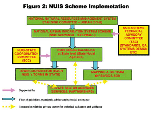
State of the art global communication technologies and thriving economy is facilitating Indian cities to compete in the global environment. The constant transformation of urban areas into complex entities has brought forth new challenges and opportunities for Planners to design and implement a variety of activities in spatial terms. There is need to tread common ground so as to address problems and issues in the right perspective to assist cities in coping with economic realities and thereby produce high quality responsive environment and demonstrate successful urban solutions.

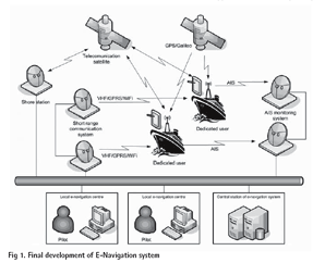
The common objective shared by all the Member States of IMO (International Maritime Organization) is a commitment to deliver safe, secure and effi cient shipping on clean oceans. The co-sponsors of this submission believe that IMO now has an opportunity to develop and map out a clear strategic vision for one common integrating and utilizing all the navigational technological tools at our disposal to secure a greater level of safety and incident prevention which will, at the same time, deliver substantial operating efficiencies with resulting commercial benefi ts, whilst also continuing to respect the freedom of navigation rights.
July 2007
Cambridge Conference 2007
15-20 July Cambridge, UK
www.ordnancesurvey.co.uk/
Asia Oceania Geosciences Society, 4th Annual Meeting
30 July – 3 August, Bangkok, Thailand
August 2007
7th International Workshop of Geographical Information System
1-3 August Beijing, China
iwgis@lreis.ac.cn
XXIII International Cartographic Conference
4-10 August, Moscow, Russia
info@icc2007.com.
GIS 14 Conference
14-15 August 2007
Vietnam
2nd Indonesian Geospatial Technology Exhibition
29 August – 1 September
Bakosurtanal; Jakarta
http://www.geospatial-exh.com/
September 2007
51st Photogrammetric Week
3-7 September
Stuttgart, Germany
martina.kroma@ifp.uni-stuttgart.de
http://www.ifp.uni-stuttgart.de/favicon.ico
INTERGEO …


 (5.00 out of 5)