Articles in the Articles Category
Jan 2006 | Comments Off on GNSS 2005


The International Symposium on GPS/GNSS was held in Hong Kong 2005 …

Jan 2006 | Comments Off on 25th INCA Congress


Dr HS Gour University, Sagar (MP) organised the 25th …

Jan 2006 | Comments Off on An open GNSS receiver platform architecture
pic1

In early 2004 a plan was hatched to develop a Global Navigation Satellite System (GNSS) receiver based around Field Programmable Gate Array (FPGA) technology as a platform to support research in this fi eld. A joint project was set up between the School of Surveying and Spatial Information Systems (SISS) at the University of New South Wales and the National ICT Australia (NICTA), and soon after a small team was established. The team consisted of Kevin Parkinson, a post-graduate student at SISS with experience in FPGA and circuit board design, Frank Engel, a researcher with NICTA with software, Real Time Operating Systems (RTOS) and VHDL design knowledge and me, Peter Mumford from the SISS GNSS research group. At the end of the project we hoped to have an L1 GPS receiver running on a custom circuit board with the baseband processor and navigation solution processor running on an FPGA chip. The project is coming to an end now, and in this article, I will describe our design path, what has been achieved to date and then some potential research areas, but fi rst a little background.

Jan 2006 | Comments Off on Advances in GPS/GNSS data processing
table-c

GNSS is a global navigation satellite system comprising of network of satellites that transmit ranging signals used for positioning and navigation anywhere around the globe; on land, in the air or at sea. The US Global Positioning System (GPS/Navstar GPS), the Russian Global Navigation Satellite System (GLONASS) and the upcoming European GALILEO system, Data communications satellites with navigation payloads and Augmentation systems are all part of GNSS.

Jan 2006 | Comments Off on On a different note?


What leads us to make a map?
A desire to locate from anything to everything …

Jan 2006 | Comments Off on MARK YOUR CALENDAR

January 2006


First Asia-Pacific Conference for ESRI Users January 12-13, …

Jan 2006 | Comments Off on Tsunami Warning System
3

A major tsunami is caused by an earthquake, which …

Jan 2006 | Comments Off on A 2006 mapping challenge
3

 
Kumar Mapping (KMap) System
I recently checked the following two “real” products …

Dec 2005 | Comments Off on Geodetic infrastructure in India
table1

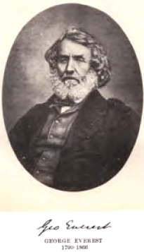
The Great Trigonometrical Survey of India was completed in 19th century under leadership of the great surveyors- Lambton and Sir George Everest. It is inconsistent and inadequate. Accuracy of the network is only of the 1st order or less. First order was defined as better than only 1 in 50,000 only. Reference surface and Datum- The Everest Spheroid was given by Sir George Everest in 1830. Center of Everest Spheroid is about a km away from the center of gravity of the Earth; hence it is non-geocentric. Thus it is inaccurate and unsuitable under present circumstances. Leveling network of India has inconsistencies. Gravity observations were not carried out and not taken in to consideration. It was not appropriately adjusted. Indian Absolute Gravity Datum does not exist. Absolute gravimeters have not yet been used to define Gravity Datum in India. Topographical maps are on Polyconic projection. Assumptions and approximations accepted make it a non-projection. The earth is assumed to be fiat and there are no distortions of any kind. The projection has created problems in digitization, compilation and integration of maps. Design of the Grid adopted in India is not satisfactory. Distortion at central parallel is 1 in 824, which is quite high. There is archaic Restriction policy, which is not transparent and hinders research and development India has to make a choice between chaos and development. These problems have been discussed in detail in this paper. How India should go about to establish new geodetic infrastructure for systematic development and research, has been described in this paper.

Dec 2005 | Comments Off on Measuring geopotential difference between two points
graph1

Conventionally, the potential difference between two points P and Q located on the Earth’s surface are determined by gravimetry and levelling (Heiskanen and Moritz 1967), the drawback of which is that it is almost impossible to connect these two points in the case that they are located on two continents, because it is well known that the potential surface of the mean sea level (MSL) is not an equipotential surface. In another aspect, if given the gravity data on the Earth’s surface, one might determine the potential difference between two points by using the Stokes method or Molodensky method (ibid). In this case the potential field is determined and consequently the potential difference between two arbitrary points could be determined.