Articles in the Articles Category


Europe is building its own global satellite navigation system, Galileo, which will offer very accurate positioning and timing, under civilian responsibility. This system will be compatible with the two other existing systems, GPS and GLONASS. A user will be able to use the same receiver to calculate his position from signals sent out by any satellites combination, however Galileo will offer to all users a bi frequency system that will allow knowing position within one meter of accuracy, which is unprecedented for an openly accessible service. Apart from extreme circumstances, it will always be available and its users will be informed in a few seconds of a potential disruption of one of the satellites. Thus it will be usable for safety of life applications, requiring the highest security level, such as plane landing, train circulation or car guidance.

Any look into the crystal ball of (even the near) future is fraught with caveats, error, and less than perfect clarity. However, certain extrapolations and not-so-wild guesses do exist.
GNSS, General – Existing (and near term proposed) systems will continue to expand, receive modernization support, and move (slowly) towards increased interest in securitizing systems and data utilized in the GNSS sourceto- user “food chain”. Nationalism of systems and (at least regionalism of) augmentation sources will progress.

There are lots of needs for a unified platform that allows efficient GNSS (Global Navigation Satellite System) receiver development and testing for various applications. With the current functionality of the GPS constellation and the promise of the future Galileo constellation, many efforts have been focused on the 1575.42MHz L1 signals for the GNSS software receiver implementation. GPS (Global Positioning System) L1 or Galileo E1…

Prem Shanker
Goel is Secretary to the Government of India,
Ministry of Earth Sciences (MoES).
India has recently launched the National Tsunami Early Warning System (TEWS) established by Ministry of Earth Sciences. Coordinates discussed various aspects of the TEWS with Dr P S Goel, Secretary to the Government of India, Ministry of Earth Sciences
Who can forget December 26, …
In looking ahead at what milestones we may expect to see during 2008 in the world of GPS and GNSS it is easy to be caught at one of two extremes. The first extreme would be to make the mistake of the shortsighted person who in the late nineteenth century proposed that the US Patent Office should be closed because everything conceivable had already been invented. The other extreme would be to look ahead at the promise of new constellations…
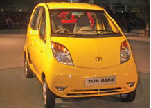
Nano effects
A historic moment.
For the automobile industry and for India too.
Tata unveiled small car Nano with a price tag of US$ 2,500.
When this ‘car for masses’ was promised, many did not believe.
Now it is a reality.
A revolutionary innovation.
An innovation that may change the life of millions.
GNSS technology too has this potential.
For imaginative applications and wider …

Ajay Seth,
Managing Director of Elcome Technologies on being acquired by Hexagon
What was the thought behind this acquisition?
The Indian market is growing very rapidly. From Hexagon’s perspective as well as the Indian point of view, we need to grow faster and this requires investment. Hexagon could help us achieve this …
January 2008
Institute of navigation national technical Meeting
January,28-30, 2007,
San Diego, California, USA
www.ion.org
February 2008
Mobile World congress 2008
February 11 – 14,
Barcelona, Spain
www.mobileworldcongress.com
Munich satellite navigation summit
19 – 21 February, 2008,
Residenz München, Germany
http://www.munich-satellitenavigationsummit.org/
GSDI-10 St.Augustine, Trinidad
February 25-29, 2008
http://www.gsdi.org/gsdi10/
NavtechGPS Seminars
February 25-29, 2008
New Orleans, LA
PWitt@navtechgps.com
March 2008
CeBIT
March 4-9,
Hannover Germany
www.cebit.de
WAlIS Forum 2008
March 12-14,
Perth, Western Australia
forum@walis.wa.gov.au
http://www.walis.wa.gov.au/forum
April 2008
GEO-SIBERIA 2008
April 22 – 24, 2008,
Novosibirsk , Russia,
strutz@sibfair.ru
http://geosiberia.sibfair.ru/eng/n
Space …

Rakesh Verma
CEO, MapMyIndia,
CE Systems on navigation market in India
How do you see the success of the Navigator in India where we culturally depend on word of mouth for directions?
There is a significant need for a GPS navigation device for all India . Depending on word of mouth for directions has set in as culture in …
January 2008
Institute of navigation national technical Meeting
January,28-30, 2007,
San Diego, California, USA
www.ion.org
February 2008
Mobile World congress 2008
February 11 – 14,
Barcelona, Spain
www.mobileworldcongress.com
Munich satellite navigation summit
19 – 21 February, 2008,
Residenz München, Germany
http://www.munich-satellitenavigationsummit.org/
GSDI-10 St.Augustine, Trinidad
February 25-29, 2008
http://www.gsdi.org/gsdi10/
NavtechGPS Seminars
February 25-29, 2008
New Orleans, LA
PWitt@navtechgps.com
March 2008
CeBIT
March 4-9,
Hannover Germany
www.cebit.de
WAlIS Forum 2008
March 12-14,
Perth, Western Australia
forum@walis.wa.gov.au
http://www.walis.wa.gov.au/forum
April 2008
GEO-SIBERIA 2008
April 22 – 24, 2008,
Novosibirsk , Russia,
strutz@sibfair.ru
http://geosiberia.sibfair.ru/eng/n
Space …


 (5.00 out of 5)