Articles in the Articles Category

In looking ahead at what milestones we may expect to see during 2008 in the world of GPS and GNSS it is easy to be caught at one of two extremes. The first extreme would be to make the mistake of the shortsighted person who in the late nineteenth century proposed that the US Patent Office should be closed because everything conceivable had already been invented. The other extreme would be to look ahead at the promise of new constellations…
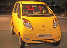
Nano effects
A historic moment.
For the automobile industry and for India too.
Tata unveiled small car Nano with a price tag of US$ 2,500.
When this ‘car for masses’ was promised, many did not believe.
Now it is a reality.
A revolutionary innovation.
An innovation that may change the life of millions.
GNSS technology too has this potential.
For imaginative applications and wider …

Ajay Seth,
Managing Director of Elcome Technologies on being acquired by Hexagon
What was the thought behind this acquisition?
The Indian market is growing very rapidly. From Hexagon’s perspective as well as the Indian point of view, we need to grow faster and this requires investment. Hexagon could help us achieve this …
January 2008
Institute of navigation national technical Meeting
January,28-30, 2007,
San Diego, California, USA
www.ion.org
February 2008
Mobile World congress 2008
February 11 – 14,
Barcelona, Spain
www.mobileworldcongress.com
Munich satellite navigation summit
19 – 21 February, 2008,
Residenz München, Germany
http://www.munich-satellitenavigationsummit.org/
GSDI-10 St.Augustine, Trinidad
February 25-29, 2008
http://www.gsdi.org/gsdi10/
NavtechGPS Seminars
February 25-29, 2008
New Orleans, LA
PWitt@navtechgps.com
March 2008
CeBIT
March 4-9,
Hannover Germany
www.cebit.de
WAlIS Forum 2008
March 12-14,
Perth, Western Australia
forum@walis.wa.gov.au
http://www.walis.wa.gov.au/forum
April 2008
GEO-SIBERIA 2008
April 22 – 24, 2008,
Novosibirsk , Russia,
strutz@sibfair.ru
http://geosiberia.sibfair.ru/eng/n
Space …

Rakesh Verma
CEO, MapMyIndia,
CE Systems on navigation market in India
How do you see the success of the Navigator in India where we culturally depend on word of mouth for directions?
There is a significant need for a GPS navigation device for all India . Depending on word of mouth for directions has set in as culture in …
January 2008
Institute of navigation national technical Meeting
January,28-30, 2007,
San Diego, California, USA
www.ion.org
February 2008
Mobile World congress 2008
February 11 – 14,
Barcelona, Spain
www.mobileworldcongress.com
Munich satellite navigation summit
19 – 21 February, 2008,
Residenz München, Germany
http://www.munich-satellitenavigationsummit.org/
GSDI-10 St.Augustine, Trinidad
February 25-29, 2008
http://www.gsdi.org/gsdi10/
NavtechGPS Seminars
February 25-29, 2008
New Orleans, LA
PWitt@navtechgps.com
March 2008
CeBIT
March 4-9,
Hannover Germany
www.cebit.de
WAlIS Forum 2008
March 12-14,
Perth, Western Australia
forum@walis.wa.gov.au
http://www.walis.wa.gov.au/forum
April 2008
GEO-SIBERIA 2008
April 22 – 24, 2008,
Novosibirsk , Russia,
strutz@sibfair.ru
http://geosiberia.sibfair.ru/eng/n
Space …

The LBS stream
It’s integral to the day-to-day functioning in the developed world.
In Asia, Japan and Korea lead the way.
The undercurrents are becoming visible in India.
First, it was the state-owned BSNL to join the LBS bandwagon.
Later, the private player Bharti Airtel followed suit.
Market dynamics indicate positive trends for LBS.
With the mobile phones holding the pulse of …

There are many different types of technologies employed in calculating the location of handsets in wireless networks with various levels of success and accuracy. Assisted-GPS (A-GPS) is a positioning technology that is presently used for locating handsets in wireless networks and is gaining traction in the market. An A-GPS server provides assistance data to the handset in order for it to have a low Time to First Fix (TTFF), weak signal acquisition and optimize handset battery use. A-GPS is used as a location technology in isolation or hybridized with other positioning technologies that provide range-like measurements.
According to a report by ABI Research, there will be over 240 million GPS-enabled mobile phones in 2008. Many of these phones will find their way into India, which translates into a huge opportunity for the Indian GPS/ GIS industry. But will these millions of GPS enabled handhelds be used for navigation alone? The probability is low…
They went up a hill to fetch a pail of water. Jack fell down and broke his bone and Jill came tumbling after… And now they need medical attention and must locate a medical center soon. How far is the nearest hospital? How do they get there from the accursed hill? What is their current location? They need location-based services (LBS). “What is LBS?” asks Jill….


 (5.00 out of 5)