Articles in the Articles Category

Is the name DAT/EM an acronym, or is there some other signifi cance behind it?
DAT/EM (pronounced dāt’-əm) is an acronym for Digital Automated Technology / Engineering Mapping. The software was developed internally between 3 production mapping fi rms located in the United States in the mid 1980’s. As such, our software was conceived in a production environment to meet the demanding technical needs of top-fl ight photogrammetric organizations. Since the fi rst data collection licenses were sold in 1987 (on analogue stereoplotters), we have never lost sight of the need for constant improvement of the software. We have always understood if the software tools can save a user one key-stroke (or more!) on a repetitive command, this will have a direct and positive infl uence on the company’s profi tability.
August 2009
Bentley Be Connected Online Seminars
23 July-30 Nov.
www.bentley.com/BeConnected
September 2009
2nd GNSS Vulnerabilities & Solutions Conference
Sept 2 to 5, 2009
Baska, Krk Island, Croatia
http://twitter.com/BaskaGNSS2009

GPS import in India was derestricted in Jan,04 – Bal Krishna, june’05
If we go strictly by rule that exists on paper, making a GPS operational without a license from WPC is not allowed – P. K. Garg, July’05If GPS needs a license to operate in India then what is the procedure
for obtaining that license – Sudipto Roy, Jan07
It was easy to have detected Sumatra Offshore Earthquake from GPS – Shunji Murai and Harumi Araki, July’05 Rapid data acquisition and information services have contributed greatly to the rescue work and disaster relief efforts in Wenchuan Earthquake – Deren Li, July’08

Basic Act on the Advancement of Utilizing Geospatial Information was approved by the cabinet in Japan last year. It states the promotion of the various kinds of the applications of geodetic information in both private and public areas to realize the convenient and safe society. The supplementary budget to save the economical crises this year in Japan prepares a lot of money to promote the utilization of geographic information. In order to realize such society in near future,…
This conference is a milestone in our GSDI journey. The huge size of the conference program points to the relevance and level of interest in the subject areas of the conference partners. The conference has shown, once again, the essential requirement for the Association to partner in order to delivering credible outcomes, with INSPIRE and Geonovum at this event, as we did with FIG in GSDI 9.

Fifty months ago, the journey started.
With passion, confi dence and conviction.
All the while, we navigated through technology trends.
Raised issues and followed up.
Captured the pulse of the market.
Added dimensions to the domain (refer page number 16).
Presence was felt, impact is notable.
And the journey continues…
July 2009
Bentley Be Connected Online Seminars
23 July-30 Nov.
www.bentley.com/BeConnected
Almost 20 years ago, as a Surveyor in private practice, and as someone who had a passing interest in politics, I presented a paper at a surveying conference, titled “Surveying the Political Landscape. At the time I had no ambition to stand for political office as I was more than fully occupied with my Surveying and Mapping business which was busy adopting new technologies such as Geographic Information Systems and Global Positioning Systems…
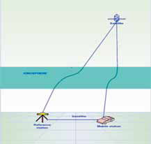
Global Positioning System (GPS) is currently one of the most popular global satellite positioning systems due to global availability of signal and performance. GPS employs two carrier frequencies which is L1 and L2 allowing receivers equipped with dual frequency operation to be used. Due to the inhomogeneity of the propagation medium in the ionosphere, the GPS signal does not travel along a perfectly straight line [1,2]…
Report on 3rd Land Administration Forum 24-26 May 2009-Tehran, Iran
The UN sponsored Permanent Committee …


 (5.00 out of 5)