Articles in the Articles Category

MICHIBIKI
Asia seems to be emerging.
As a new centre for satellite navigation.
China is moving fast.
India is maintaining its own pace.
Now Japan is set to touch the zenith.
With the scheduled launch of MICHIBIKI.
The first satellite of Quasi-Zenith Satellite System (QZSS).
A landmark in the regional navigation system.
The sun rises.
Again in the East.
Bal Krishna, Editor
bal@mycoordinates.org
Tweet

Sherman Lo, Benjamin Peterson, Per Enge
This article assesses the security of eLoran and discusses how its features can be utilized to provide defenses against likely attacks
Global Navigation Satellite Systems (GNSS) have become increasingly interwoven into the fabric of our infrastructure and economic system. However, as the services provided by GNSS become more important for safety …

Niki Regina, Matteo Zanzi
In this paper three different solutions are proposed for the problem of location-based selective broadcasting of traffic messages
Although at present its implementation within the full operational capability is under discussion and called into doubt due to recent changed circumstances in the overall system management, one of the initially planned features of GALILEO …

James L Farrell, John W lavrakas
Addressing GPS user problems
While GPS offers a ubiquitous, precise, and reliable positioning and timing service to much of the world, in many cases this service falls short. Anyone who has walked into a building with a GPS receiver actively displaying a location is aware of the immediate effect of the …
September 2010
GDI APAC
28-30 September
kuala Lumpur, Malaysia
www.geopatialdefenceasia.com
International Astronautical Congress 2010
27 Sep – 01 Oct
Prague Czech Republic
iac2010@guarant.cz
www.iac2010.cz/en
Geospatial Intelligence Summit
28-30 September 2010
Vienna, Austria
www.jacobfleming.com
October 2010
INTERGEO
5-7 October
Cologne, Germany
www.intergeo.de
3rd Int Conf on Geoinformation Tech for Natural Disaster Management
19-20 October 2010
Chiang Mai, Thailand
http://www.egeinfo.net/git4ndm2010/
GSDI-12 World Conference
19-22 October
Singapore
www.gsdi.org
CANEUS-Shared Small Satellites CSSP Int. Workshop
20-22 Oct
Tuscany, Italy
www.caneus.org/sharedsmallsats
International Symposium on GPS/GNSS
26-28 October
Taipei, Taiwan
http://gnss2010.ncku.edu.tw
November 2010
GEOINT 2010
1-4 November
New Orleans, …

Phase centre is defined as a point (or a set of points) in space from which, when emitted, far-field phasefronts or, correspondingly, group-delay fronts are spherical or substantially spherical [1-2]. That is, the phase value is constant in a certain angular area of interest when measured with respect to the coordinate system whose origin is in the PC. However, PC is ambiguous for most of the real-life antennas and its position varies for…
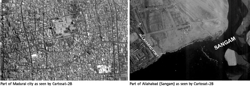
Latest Indian RS Satellite Cartosat-2B and a Dream’ of students
India’s Polar Satellite Launch Vehicle (PSLV-C15) successfully launched CARTOSAT-2B from Satish Dhawan Space Centre (SDSC) SHAR, Sriharikota on 12 July 2010.
In addition to CARTOSAT-2B; PSLV-C15 carried four auxiliary satellites namely STUDSAT a pico-satellite weighing less than 1 kg, built jointly by students from a consortium …

says Shri KR Sridhara Murthi, Managing Director, Antrix Corporation with reference to the Indian Remote Sensing Satellite.
What are the added features in CARTOSAT-2B as compared to CARTOSAT-2A? What will be its marketing strategy?
CARTOSAT-2B is an identical satellite of CARTOSAT-2A and is meant for continuity of services. They are not available for commercial distribution. As …

Says V P Agrawal, Chairman, Airports Authority of India
In what specific areas of operation is AAI using the GPS technology today?
GPS Technology is used in AAI in the following areas:
a. Performance Based Navigation- Area Navigation COSPAS-SARSAT –Search and Rescue systems (satellite based)
b. Land Survey and Land Management
c. Preparation of Airport Maps and Charts – Cartography
Please …

Says John Pottle Marketing Director, Spirent Communications, Positioning Group
2009 was seen as a difficult year for most businesses. However, 2009 was ‘as expected’ for Spirent in terms of revenues and profits, how did Spirent manage this?
Spirent sells test systems for navigation and positioning across the industry, from government to consumer products, from R&D through to …


 (5.00 out of 5)