CEOs peg 2010 growth rate at 11% According to market Research firm Daratech, GIS/Geospatial industry CEOs interviewed, were unanimous in their belief that growth consistent with the robust 11% compound annual growth rate of the past six years would return in 2010. It stated that 2009 was a tough year in the private sector GIS/Geospatial market, which is forecast to close at $1.4 billion, down 0.7%…

Galileo Satellite Platform tests under way The engineering model of the first Galileo satellites has completed platform integration tests at the Thales Alenia Space facility in Rome, reports ESA. The platform is now undergoing functional testing. Delivery of the engineering model payload from Astrium UK is expected this month. These tests are an important step towards building and launching the first four Galileo satellites. Integration testing…

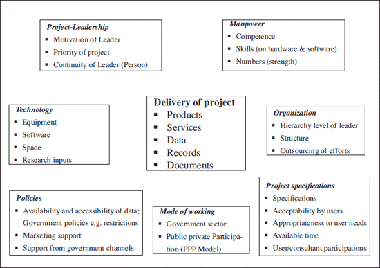
It appears that big talk and promises about the technologies (GIS et al) have still not carried weight and conviction with the user – organizations, the ultimate beneficiary of the productivity of the modern technologies. The spatial solutions have still not reached these organizations like urban development authorities. Land Information Technologies (LIT) have not delivered spatial solutions as a matter of routine or policy…

says Dr Bradford W Parkinson, Chief Architect of Global Positioning System
Dr Bradford W Parkinson
Chief Architect of Global Positioning System
Dr Parkinson oversaw the Global Positing System (GPS) program from conception through development and verification as the first GPS Program director and is best known as the ‘father of GPS’.He received his BS in general engineering …

KOICHI CHINO, DINESH MANANDHAR, RYOSUKE SHIBASAKI
The paper proposes basic concepts how to realize the Secure and Safety Tracking System (special for food, food material) between different countries
As the world becomes a smaller place, countries are becoming more dependent on each other in many fields. Goods like industrial products, food and other materials are easily exported and imported …

INDUSTRY | LBS | GPS | GIS | REMOTE SENSING | GALILEO UPDATE
Leica Geosystems announces digitizer for LIDAR
Leica Geosystems announced the introduction of a full-waveform digitizer, WDM65, designed specifically for use with its ALS-series airborne LIDAR Systems. www.leica-geosystems.com
V9 of H2ONET released
MWH Soft announced the worldwide availability of H2ONET Generation V9 for AutoCAD® 2010. …


 (5.00 out of 5)