
CEOs review the progress of EGNOS
The CEOs of the Members of the European Geostationnary Navigation Overlay Service (EGNOS) Operators and Infrastructure Group (EOIG) and of the ESSP met recently in Paris to review the progress of EGNOS. The fi rst in-fl ight operational trials conducted recently in Spain, Switzerland and France have confi rmed the capability of EGNOSbased approaches similar to existing precision approaches (Cat I) supported today by conventional navigation systems, in line with the high standard safety procedures of civil aviation.
The European Commission Communication is proposing to secure the fi nancing of EGNOS for the next six years with public funding. The CEOs of the EOIG urge the States to achieve a fi nancial resolution in October 2007, in order to guarantee the success of the launching phase of EGNOS as a new air navigation system. michel.
calvet@aviation-civile.gouv.fr
The 7th International Navigational Symposium on Marine Navigation and …

Airtel announces GPS navigation
Bharti Airtel, in collaboration with Sweden-based Wayfi nder Systems, launched its GPS-based Navigation Application on compatible mobile handsets. The systems is complete with detailed maps and points-of-interest of several cities across the country. It will be available on the BlackBerry 8800 and will cover information on cities including Delhi and NCR, Bangalore, Mumbai & Navi Mumbai, Thane, Pune, Chennai, Hyderabad, Kolkata, and Chandigarh. www.techtree.com

Leica GMX902 GG and Leica ScanStation 2
The Leica GMX902 GG is a highperformance GPS + GLONASS receiver, specially developed to monitor sensitive structures such as bridges, mines or high rise buildings and crucial topographies such as land slides or volcanoes. Leica has also announced a major advance in the capabilities of pulsed (or “time-of-fl ight”) laser scanners for as-built and topographic surveys. The maximum speed for ‘ScanStation 2’ is 50,000 points/second, more than 10-times that of its ScanStation predecessor (4,000 points/second) and the highest in the industry for pulsed scanners. www.leica-geosystems.com
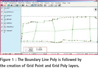
LAND forms important part of development activity. Land revenue is one of the sources of income for state governments. It may come from land holdings by private individuals, real estate transactions or other natural resources being tapped by various sections of the society. Hence, creation of a Land Information Management System involves
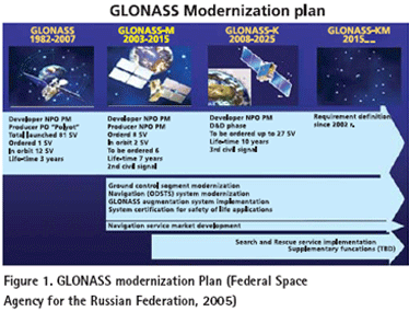
THE conventional geomatics industry including mapping and surveying applications has been revolutionized with the use of GPS, which is the best known, and currently fully operational satellite based navigation system operated by USA (Parkinson, and Spilker Jr., 1995). In the mean time, Russia also operates its own satellite based navigation system called GLONASS. The USA is modernizing GPS in order to retain its superiority in satellite based navigation technologies (MacDonald, 2002,). In order to keep up with USA’s progress in building next generation system, Russia is taking serious steps to modernize GLONASS as well (Federal Space Agency for the Russian Federation, 2005). The GPS and GLONASS signals are free but its availability is not guaranteed and currently most users are prepared to accept this risk (Parkinson, and Spilker Jr., 1995). However, as satellite navigation becomes a vital technology across a number of critical industrial sectors, the prospect of, for example, a nation’s transport infrastructure becoming dependent on this technology is a strategic risk that most industrial countries are not willing to accept. This argument initiated the Galileo program in Europe. Therefore, those systems form the mainframe of Global Navigation Satellite Systems (GNSS) (MacDonald, 2002,).






 (5.00 out of 5)