

The GNSS Research and Application Centre of Excellence (GRACE), is a cross disciplinary centre providing cutting edge research, high calibre teaching, and business support services to the GNSS community. In October 2009 GRACE will move into its own state-of-the-art purpose built centre. A ground breaking ceremony took place on the 11th of November 2008, and construction of the centre is underway at the University of Nottingham Innovation Park (UNIP) on the Jubilee campus of the University of Nottingham.
It will be the only facility in UK dedicated to the development of downstream applications and services using GNSS. The European Union has estimated the market for downstream applications and services to be worth in excess of £230 billion by the year 2025. Supporting the University of Nottingham in this venture which will have an investment of £9.2m is the East Midlands Development Agency (EMDA), one of the nine regional development agencies in England. EMDA was established in 1999 with the primary goal to increase the economic growth of the East Midlands region.
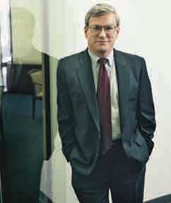
Says Steve Berglund, president and CEO of Trimble in an exclusive interview with Coordinates
Can you describe some defining …

Adding GRACE to GNSS
National Land Records Modernisation Programme: Misson Possible
Flight Evaluation of a GPS Attitude Determination Algorithm
Dr Nelson Paiva Oliveira Leite and Prof Dr
Fernand o Walter
A sensor architecture for high precision UAS navigation
Luca Garbarino, Vittorio Di Vito, Ettore De Lellis, Carmine Marrone, Federico Corraro
Norway joins Galileo project
The Norwegian government will give a boost by providing 68.9 million euros (92.5 million dollars) towards the 3.4 billion euro project. While Norway is not a member of the 27-member bloc, the
country’s economy and business minister Sylvia Brustad said it was important that Oslo took part in Galileo’s development. “The project will be of huge importance for the development of the European space industry and it is therefore important that Norwegian businesses are now able to compete,” Brustad said in a statement. In
September, the European Commission and the European Space Agency, which includes Norway as a member, shortlisted 11 European firms which are bidding for future contracts connected to Galileo. www.newsabout- space.org/story/157986254.html

On August 21, 2008 the cabinet approved the proposal of the Department of Land Resources (DoLR), Ministry of Rural Development to merge two existing centrally sponsored schemes and replace them with the modifi ed scheme of National Land Records Modernization Program (NLRMP). The two schemes being merged are the Strengthening of Revenue Administration & Updating of Land Records (SRA&ULR) and Computerization of Land Records (CLR).
RISAT – ISRO’s SAR satellite, launched
ISRO’s Polar Satellite Launch Vehicle (PSLV-C12), on April 20, 2009 successfully placed two satellites – RISAT-2 and ANUSAT – in the desired orbit. RISAT-2 is a Radar Imaging Satellite with the capability to take images of the earth during day and night as well as cloudy conditions. This satellite will enhance ISRO’s capability for earth observation, especially during disaster management. ANUSAT, built by Anna University, Chennai is the first experimental communication satellite built by an Indian University under the guidance of ISRO and will demonstrate the technologies related to message store and forward operations. www.isro.org
EXPRESSMaps delivers detailed maps in 6 hours
Spot Image and Infoterra are launching www.express-maps.com to deliver detailed basemaps covering over three quarters of the Earth’s land surfaces. This service creates 1:50000 basemaps, which can be delivered electronically in just 6 hours. It is mainly aimed at civil protection agencies, military and humanitarian aid teams in crisis management situations. www.infoterra.fr
China launches navigation satellite
China launched Beidou-2 (or Compass- G2) – their second geostationary navigation satellite recently. The Compass constellation comprises 31 satellites – 27 MEO satellites and 4 geostationaries. BeiDou-2 is reported to have a lifespan of 8 years. The first phase of the project will provide coverage for Chinese territory – ultimately giving global cover. www.nasaspaceflight.com
Galileo and China’s Compass argue over frequencies
The Christian Science Monitor reports that China’s insistence on using the same radio frequency as Galileo may render some features of the European system unusable in the event of a crisis. China’s membership of “Galileo,” has soured to the point where the two sides are locked in a dispute over radio frequencies, as China races ahead with its own network of satellites. Without an agreement, China would be able to frustrate European military forces’ efforts to deny a future enemy crucial satnav capability. http://survapedia. com/2009/03/galileo-china-argue/
April 2009
GEO Siberia 2009
21-23 April
Novosibirsk, Russian
nenash@sibfair.ru
http://www.geosiberia.sibfair.ru
Defence Geospatial Intelligence Middle East
26 – 29 April
Dubai
enquiry@iqpc.ae
http://www.geospatialdefence.com
May 2009
ENC-GNSS 2009 )
3-6 May
Naples, Italy
http://www.enc.gnss09.it
International Conference on Integrated Navigation Systems
25-27 May
Saint Petersburg, …


 (5.00 out of 5)