
Chandrayaan-1 completes mission
The Indian Space Research Organisation has completed all the primary objectives of the Chandrayaan-1 lunar reconnaissance mission. The scientifi c objective of the spacecraft was remote sensing of the Moon in visible, near infra-red, low energy x-ray and high-energy x-ray regions. The intention is to prepare a 3-D atlas of both the near and far side of the moon, with a high spatial and altitude resolution – down to fi ve metres in the optical. www.isro.org
This conference is a milestone in our GSDI journey. The huge size of the conference program points to the relevance and level of interest in the subject areas of the conference partners. The conference has shown, once again, the essential requirement for the Association to partner in order to delivering credible outcomes, with INSPIRE and Geonovum at this event, as we did with FIG in GSDI 9.

Fifty months ago, the journey started.
With passion, confi dence and conviction.
All the while, we navigated through technology trends.
Raised issues and followed up.
Captured the pulse of the market.
Added dimensions to the domain (refer page number 16).
Presence was felt, impact is notable.
And the journey continues…
July 2009
Bentley Be Connected Online Seminars
23 July-30 Nov.
www.bentley.com/BeConnected
Study GIS at Hong Kong Polytechnic
The Department of Land Surveying and Geo-Informatics at the Hong Kong Polytechnic University is now accepting applications for Master of Science/ Postgraduate Diploma in Geomatics (GIS/ Surveying). It is the longest running postgraduate program in GIS and the only one in Geomatics (Surveying) in Hong Kong. www.lsgi.polyu.edu.hk

Safe Navigation in Korea
In Korea, the Ministry of Land, Transport and Maritime Affairs shall soon provide small ships off the coast of the Korean peninsula with differential GPS information through mobile phones and other personal devices. Until now small avoided using professional equipment because of the price of the hardware. http://english.mltm.go.kr

Different strokes
Akio Yasuda, Al Stevens, Chirs Goodall, Naser El-Sheimy, Orhan Altan, Frank Derby, George Cho, Brent A Jones, Dietrich Schroder, P Mishra
Adding dimensions to the domain
Malaysia precise positioning
Norsuzila Ya’acob, Mardina Abdullah and Mahamod Ismail
SPATIAL needs political champions
Gary Nairn

Almost 20 years ago, as a Surveyor in private practice, and as someone who had a passing interest in politics, I presented a paper at a surveying conference, titled “Surveying the Political Landscape. At the time I had no ambition to stand for political office as I was more than fully occupied with my Surveying and Mapping business which was busy adopting new technologies such as Geographic Information Systems and Global Positioning Systems…
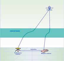
Global Positioning System (GPS) is currently one of the most popular global satellite positioning systems due to global availability of signal and performance. GPS employs two carrier frequencies which is L1 and L2 allowing receivers equipped with dual frequency operation to be used. Due to the inhomogeneity of the propagation medium in the ionosphere, the GPS signal does not travel along a perfectly straight line [1,2]…
Report on 3rd Land Administration Forum 24-26 May 2009-Tehran, Iran
The UN sponsored Permanent Committee …


 (5.00 out of 5)