Articles tagged with: Prof P Misra


There is no denying of a characteristic that marketing as a concept and priority do not go hand-in-hand with the good departments. Survey of India, National Remote Sensing Centre, Geological Survey of India, Forest Survey of India, National Bureau of Soil Surveys and Land Use Planning (NBSS & LUP) and many other member-organization of NSDI are no exception. As a matter of interest, if you try to know what all is available in India from the portals of NSDI and other organizations, you are hardly rewarded by the desired information…
The need – environment of an Urban Information System has undergone a sea change over the last few years. Couple of years back the requirements of information system was designed and projected primarily from the planners community. They were satisfied if the physical information was supplied on a scale of 1:5000/1:10000…

Consider the scenario, date 1.1.2020: “Mr. A buys property in Meerut, city in Uttar Pradesh (UP), India from Mr. B in Dec 2019. The ownership-title that Mr. B is the Owner, is guaranteed by the Government Registrar. As a matter of fact, all the properties with the names of their owner are recorded centrally in the computer in the office of Land Survey Department of UP. The location like trees and wells, etc are all photographed on an aerial photograph…
It appears that big talk and promises about the technologies (GIS et al) have still not carried weight and conviction with the user – organizations, the ultimate beneficiary of the productivity of the modern technologies. The spatial solutions have still not reached these organizations like urban development authorities. Land Information Technologies (LIT) have not delivered spatial solutions as a matter of routine or policy…

Till almost early seventies, Survey of India was synonymous with the surveying profession in India. That situation does not exist any more. The reason is not far to find out… Many new organizations, have carved out their own niche in the domain of the surveying and mapping. These new entities have been generally propelled either by the new technology eg satellite imagery or due to unmet demand of a particular type of information – example, Forest Survey of India…

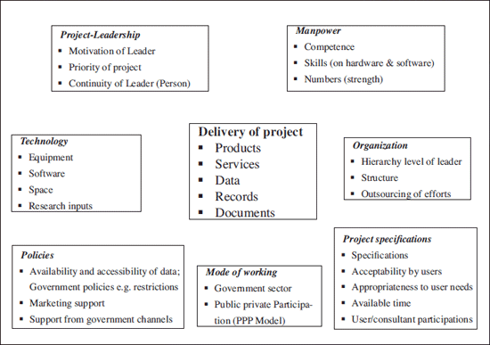
Seven out of ten customers of surveys and mapping who talk to the suppliers (consulting fi rms of surveying agencies) demand their maps to be delivered `yesterday’(!) or indeed as early as possible. These customers are `decision-makers’ who have taken some months (if not years) to come to the demand level! Same is the situation in respect of the tenders in mapping discipline. All the risks and uncertainties are put on the door of the suppliers / contractors. One should realize that although the surveying and mapping process never costs more than 1 or 2 percent of total budget, the same is not true when it comes to the time taken for the mapping project. The fact is that many projects are delayed just because the survey data of right quality and proper map was not made available to the engineer / planner.


 (5.00 out of 5)